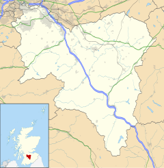
Drumsagard Village is a new construction village in Cambuslang, South Lanarkshire. It is built around the site of Drumsagard Castle and immediately south of the site of Hallside Steelworks.
The Parish of Cambuslang in the Barony of Drumsargard, also spelt Drumsagart, meaning "ridge of the priest"[1] – can be traced back to the time of King Alexander II of Scotland (1214–49) when it belonged to Walter Olifard, Justiciar of Lothian. The Barony of Drumsargard (whose castle ruins can be discerned to the south-east of Hallside although none of the structure itself now remains) passed to Archibald Douglas, 3rd Earl of Douglas in 1370, as part of the settlement in his marriage to Johanna, daughter of Thomas Moray of Bothwell. In 1452 the Douglases were displaced in favour of James Lord Hamilton, who became tenant-in-chief in 1455. This feudal superiority remained with the Dukes of Hamilton – who were also the largest landowners – up until 1922, though the abolition of feudalism in Scotland did not come until the end of the 20th Century.
Hallside Village
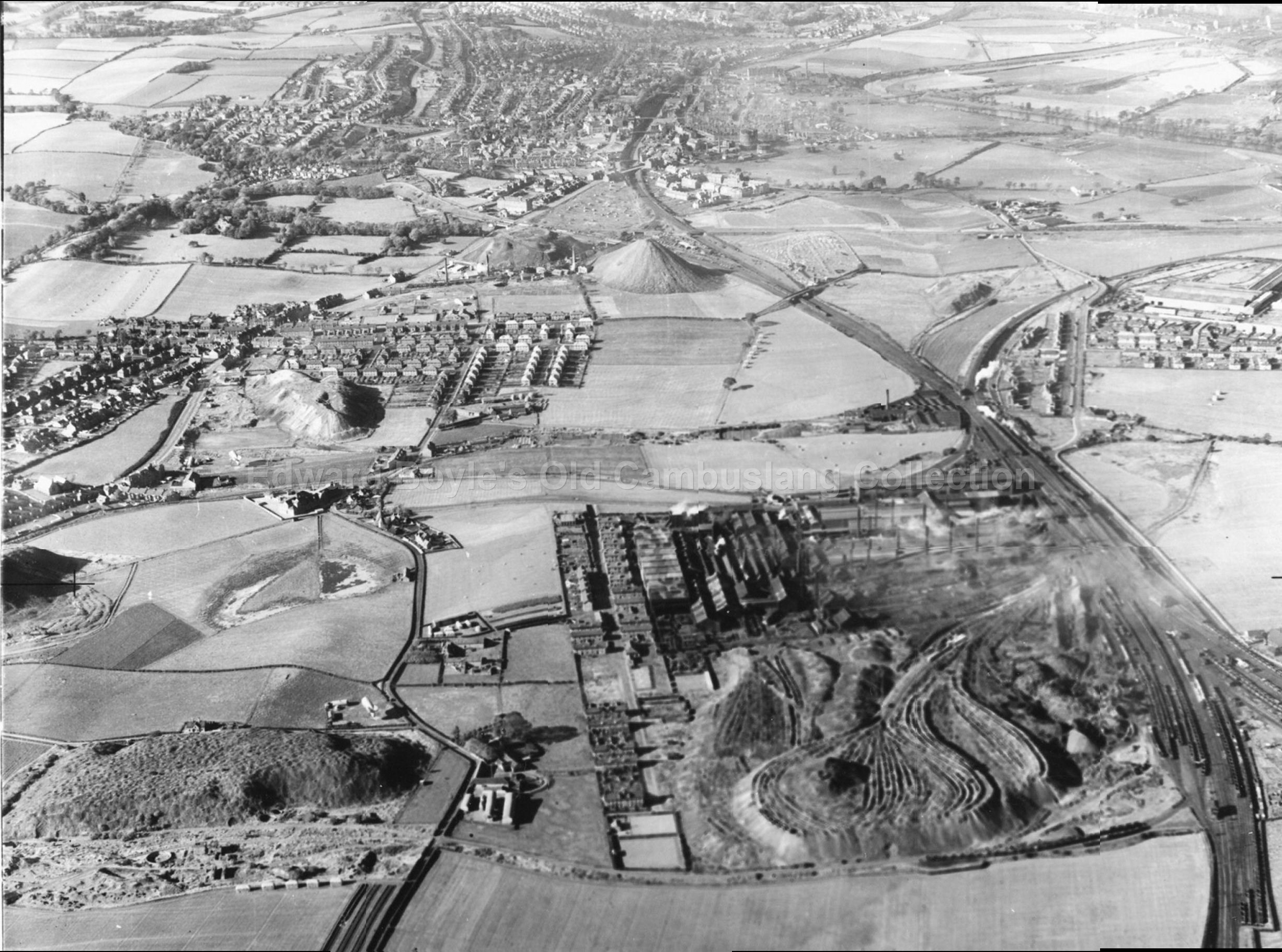
In the 19th and early 20th century there were several working farms and a small colliery on the land which is now modern housing.[2]Hallside House, the mansion overlooking the area (built by George Jardine), was located off Manse Brae at the eastern side of the parish of Cambuslang, near the boundary with Blantyre; it survived until the 1930s.[3] There was also a small community built for the steel workers and the managers which had associated schools and churches[4] but that has all but disappeared, save for a group of sandstone houses known as Hallside Village which were restored in the late 20th century.[5]
The larger part of the modern suburb was constructed in the late 1990s and early 2000s.[6] In the 2010s, one of the remaining farms (East Hallside) was demolished and converted into a further area of new housing,[7] and in 2021 planning was approved by the council for a further development (184 homes) on the eastern edge of the neighbourhood[8] despite more than 150 complaints being submitted in respect of green belt encroachment and wildlife disruption, lack of sufficient local amenities and access all being off the main A724 road rather than existing side streets.[9]
Facilities
Drumsagard retail zone
Drumsagard is within the Cambuslang East ward of the South Lanarkshire Council area which is also the extent of the neighbourhood community policing zone.[10] There is a small precinct of shops at the southern edge of the development, and the closest area with a wider range of amenities is Halfway.
There are currently two schools in the vicinity of Drumsagard – Hallside Primary, a 21st century incarnation of the previous school of the same name which was mainly attended by children of the steel workers), and Park View Primary, an additional smaller facility to accommodate the number of pupils, mostly from new homes in Drumsagard, which had become too much for Hallside despite several extensions to its capacity.[11] Both of these schools are non-denomonational; the nearest Catholic schools are St Charles' in Newton and St Cadoc's in Halfway.
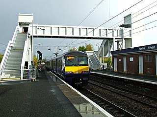
At the north side of Drumsagard is Newton railway station which links to Glasgow city centre, Cambuslang, Rutherglen and Hamilton. A major bus route at the southern boundary running between Glasgow and Hamilton, First Glasgow's '267', serves the area via Hamilton Road (A724) with stops near to the shops.
After securing a grant from 'Award for All', the residents association funded a feasibility study which resulted in the addition of sporting facilities in the village in 2010.[12] A multi-use games area and sports pitch are part of the sports facilities.[13]
Hallside Heritage Park
Between Drumsagard and the railway lines at Newton station is 'Hallside Heritage Park', a large expanse of woodland on the site of the Hallside Steelworks,[14][15][16][17] (also known as the Cambuslang Iron and Steel Works, established in 1871 as one of the first facilities of its kind and eventually extending over an area of around 33 acres, closed in 1979)[18][19] which was cleared and planted in the 1990s by the housebuilding firms to compensate for the green space lost to their developments in the area.[6][20] With little subsequent investment or attention, the land became somewhat neglected and overgrown and was eventually taken over by the local residents association,[21][22] with initial plans for improving its facilities and landscape published in 2019.[23][24]
South Lanarkshire is one of 32 unitary authorities of Scotland. It borders the south-east of the Glasgow City council area and contains some of Greater Glasgow's suburban towns, as well as many rural towns and villages. It also shares borders with Dumfries and Galloway, East Ayrshire, East Renfrewshire, North Lanarkshire, the Scottish Borders and West Lothian. It includes most of the historic county of Lanarkshire.
Rutherglen is a town in South Lanarkshire, Scotland, immediately south-east of the city of Glasgow, three miles from its centre and directly south of the River Clyde. Having previously existed as a separate Lanarkshire burgh, in 1975 Rutherglen lost its own local council and administratively became a component of the City of Glasgow District within the Strathclyde region. In 1996 the towns were reallocated to the South Lanarkshire council area.
Cambuslang is a town on the south-eastern outskirts of Greater Glasgow, Scotland. With approximately 30,000 residents, it is the 27th largest town in Scotland by population, although, never having had a town hall, it may also be considered the largest village in Scotland. It is within the local authority area of South Lanarkshire and directly borders the town of Rutherglen to the west. Historically, it was a large civil parish incorporating the nearby hamlets of Newton, Flemington, Westburn and Halfway.
Blantyre is a town and civil parish in South Lanarkshire, Scotland, with a population of 16,900. It is bounded by the River Clyde to the north, the Rotten Calder to the west, the Park Burn to the east and the Rotten Burn to the south.
Uddingston is a small town in South Lanarkshire, Scotland. It is on the north side of the River Clyde, south-east of Glasgow city centre, and acts as a dormitory suburb for the city.
Eastfield is a mainly residential district in South Lanarkshire, Scotland, located between the industrial towns of Rutherglen and Cambuslang in the south-east of the Greater Glasgow urban area. It is situated south of the River Clyde, adjoining the Stonelaw and Burnside neighbourhoods of Rutherglen, and Silverbank in Cambuslang.
Newton railway station is a railway station located between the neighbourhoods of Drumsagard, Halfway, Newton and Westburn in the town of Cambuslang, Scotland. The station is managed by ScotRail on the Argyle and Cathcart Circle Lines.
Burnside is a mostly residential area in the town of Rutherglen in South Lanarkshire, Scotland. Including the neighbourhoods of High Burnside and High Crosshill, respectively south and north-west of its main street, it borders Overtoun Park in Rutherglen plus several other residential areas of the town, as well as western parts of neighbouring Cambuslang.
The History of Cambuslang is explained to a great deal by its geography. Now in South Lanarkshire, the town of Cambuslang is an ancient part of Scotland where Iron Age remains loom over 21st century housing developments. It has been very prosperous over time, depending first upon its agricultural land, then the mineral resources under its soil.
Gilbertfield Castle is a ruined 17th-century castle in South Lanarkshire, Scotland. It is located at NS652587, on the north slope of Dechmont Hill, just outside Cambuslang, to the south-east of Glasgow.
Cathkin High School is a state secondary school in Cambuslang, South Lanarkshire, Scotland.
Halfway is a largely suburban area in the town of Cambuslang, Scotland, located within the local authority area of South Lanarkshire. It borders the smaller areas of Lightburn, Cairns, Flemington, Drumsagard and Hallside.
Newton is a mainly residential district in the town of Cambuslang in Scotland; it is situated directly south of the River Clyde. Newton is within the Cambuslang East ward of the South Lanarkshire Council area. Formerly a mining settlement from the mid-19th to mid-20th centuries then sparsely populated for several decades, in the early 2000s it was designated a 'Community Growth Area' for residential development with several hundred houses, a new primary school and associated infrastructure constructed in phases over several years into the 2020s, mostly on fields previously used by a farm which had operated for several centuries before closing around the turn of the 21st century.
The Clydebridge Steelworks, also known as Clydebridge Works, is a steel works in South Lanarkshire, Scotland.
Westburn is a district of the town of Cambuslang in South Lanarkshire, Scotland. It was formerly home to a steel works and power station which were the area's major employers; the sites are now occupied by a housing development and modern industrial estate respectively. Administratively, Westburn is within the Cambuslang East ward of the South Lanarkshire Council area and has a population of around 2,000.
Whitlawburn is a residential area in the town of Cambuslang in South Lanarkshire, Scotland. It is located south of the town centre on high ground slightly north of the Cathkin Braes, overlooking the Greater Glasgow urban area.
Drumsagard Castle, near Cambuslang, South Lanarkshire, Scotland, was a motte and bailey castle which was then built of stone. The castle was the caput of the barony of Drumsagard. Drumsagard was held in the 13th century by the Oliphant family, before it passed by marriage to the de Moravia family. It passed to the Douglas family in 1362 by the marriage of Archibald Douglas, Earl of Douglas to Johanna, daughter of Thomas Moray of Bothwell. The Hamilton family were granted the lands in 1452.
Cambuslang West is one of the 20 electoral wards of South Lanarkshire Council. Created in 2007, the ward elects three councillors using the single transferable vote electoral system and covers an area with a population of 17,418 people.
The A724 road in Scotland runs within South Lanarkshire between Rutherglen and Hamilton. It follows an ancient route which is marked on William Roy's Lowland Map of Scotland (1755) with only minor deviations from its modern course.
This page is based on this Wikipedia article Text is available under the CC BY-SA 4.0 license; additional terms may apply. Images, videos and audio are available under their respective licenses.


