Scottish Fire and Rescue Service National Training Centre

Last updated

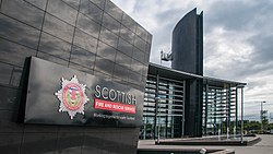
The Scottish Fire and Rescue Service National Training Centre is a purpose-built training facility in Cambuslang, South Lanarkshire. Also known as the Uaill Training Centre, it has mock buildings and areas suitable for training to use specialist fire and rescue equipment. It opened in January 2013 and is operated by the Scottish Fire and Rescue Service (SFRS).

Contents

History

A project team lead was appointed in 2007 create a new fire training centre for the Strathclyde Fire and Rescue Service. [1] A site was eventually identified at Clydesmill, on the south bank of the River Clyde near Westburn, previously a large power station. [2] [3] A linked project was also approved to close the existing local stations at Cambuslang (near its Main Street, built in 1970) and Parkhead (built 1952), [4] [5] and combine them in a new community station at Clydesmill, [6] which was completed in 2011. [7] Its community room is named after Enoch Humphries, former Fire Brigades Union president who had links to the area. [8]

Construction of the facility took 77 weeks and cost £43 million. [9] The buildings were completed in April 2012. [10] The official opening was in January 2013, [11] shortly before all eight of Scotland's fire services merged in April 2013. With the centre up and running, the Scottish Fire and Rescue Service College Gullane closed in March 2015. [12]

Design

The academic building Cambuslang4.jpg
The academic building

The centre was designed by Cooper Cromar. [13] It is built beside the Clyde on the site of the former Clydesmill Power Station, near to the village of Westburn, with National Cycle Route 75 and the Clyde walkway running alongside; it is a short distance from Junctions 2A and 3 of the M74 motorway.

The 40-acre (16 ha) site includes an academic building, a practical facilities building and three hazard zones. [13] There is a mock town with roads, rail tracks and buildings, including a multi-storey tenement structure. [9] The academic buildings were given a BREEAM rating of 'excellent'. [14] A Technical Rescue Training Zone (TRTZ) supports specialist search and rescue training. [15]

Related Research Articles

<span class="mw-page-title-main">Cambuslang</span> Scottish locality south of Glasgow

Cambuslang is a town on the south-eastern outskirts of Glasgow, Scotland. With approximately 30,000 residents, it is the 27th largest town in Scotland by population, although, never having had a town hall, it may also be considered the largest village in Scotland. It is within the local authority area of South Lanarkshire and directly borders the town of Rutherglen to the west. Historically, it was a large civil parish incorporating the nearby hamlets of Newton, Flemington, Westburn and Halfway.

Knightswood Human settlement in Scotland

Knightswood is a suburban district in Glasgow, containing three areas: Knightswood North or High Knightswood, Knightswood South or Low Knightswood, and Knightswood Park. It has a golf course and park, and good transport links with the rest of the city. Garscadden and Scotstounhill railway stations serve Low Knightswood while Westerton station serves High Knightswood. Knightswood is directly adjoined by the Anniesland, Blairdardie, Drumchapel, Garscadden, Jordanhill, Netherton, Scotstoun, Scotstounhill and Yoker areas of Glasgow, and by Bearsden in the north.

<span class="mw-page-title-main">Parkhead</span> Human settlement in Scotland

Parkhead is a district in the East End of Glasgow. Its name comes from a small weaving hamlet at the meeting place of the Great Eastern Road and Westmuir Street. Glasgow's Eastern Necropolis cemetery was laid out in the area in 1847 beside the Gallowgate.

Bridgeton, Glasgow Human settlement in Scotland

Bridgeton is a district to the east of Glasgow city centre. Historically part of Lanarkshire, it is bounded by Glasgow Green to the west, Dalmarnock to the east and south, Calton to the north-west at Abercromby Street/London Road and Gallowgate to the north-east.

Carmyle is a suburb in the east end of Glasgow, Scotland, directly north of the River Clyde. It is in an isolated location separated from the main urban area of the city and has the characteristics of a semi-rural village. Administratively, Carmyle falls under the Shettleston ward of Glasgow City Council.

Eastfield, South Lanarkshire Human settlement in Scotland

Eastfield is a mainly residential district in South Lanarkshire, Scotland, located between the industrial towns of Rutherglen and Cambuslang in the south-east of the Greater Glasgow urban area. It is situated south of the River Clyde, adjoining the Stonelaw and Burnside neighbourhoods of Rutherglen, and Silverbank in Cambuslang.

Gullane Village in East Lothian, Scotland

Gullane is a town on the southern shore of the Firth of Forth in East Lothian on the east coast of Scotland. There has been a church in the village since the ninth century. The ruins of the Old Church of St. Andrew built in the twelfth century can still be seen at the western entrance to the village; the church was abandoned after a series of sandstorms made it unusable, and Dirleton Parish Church took its place.

<span class="mw-page-title-main">Cambuslang railway station</span> Railway station in South Lanarkshire, Scotland

Cambuslang railway station is a railway station which serves the town of Cambuslang, South Lanarkshire, Scotland. The station is 5 miles (8 km) south east of Glasgow Central, and is regularly served by trains on the Argyle Line to and from Glasgow Central. Passenger services are provided by ScotRail Trains on behalf of Strathclyde Partnership for Transport (SPT).

First Glasgow

First Glasgow is the largest bus company serving the Greater Glasgow area in Scotland. It is a subsidiary of FirstGroup. The company operates within the area covered by the Strathclyde Partnership for Transport, a public body responsible for helping to co-ordinate public transport services in the Greater Glasgow area.

The Highlands & Islands Fire & Rescue Service was the statutory fire and rescue service for northern Scotland, covering the council areas of Highland, Orkney, Shetland, and the Western Isles, and so covering a major part of the Highlands and Islands area. It was the fire service covering the largest geographical area in the United Kingdom, and had its headquarters in the city of Inverness. It was established in 1975 and was amalgamated into the single Scottish Fire and Rescue Service in 2013.

The History of Cambuslang is explained to a great deal by its geography. Now in South Lanarkshire, the town of Cambuslang is an ancient part of Scotland where Iron Age remains loom over 21st century housing developments. It has been very prosperous over time, depending first upon its agricultural land, then the mineral resources under its soil.

<span class="mw-page-title-main">Strathclyde Fire and Rescue Service</span>

Strathclyde Fire & Rescue was, between 1975 and 2013, the statutory fire and rescue service for the area of Strathclyde, Scotland. It was the largest fire and rescue service in Scotland, and one of the largest in Europe. Its territory ranged from the densely populated Glasgow to remote rural and island communities. It was amalgamated into the single Scottish Fire and Rescue Service in April 2013.

<span class="mw-page-title-main">Lothian and Borders Fire and Rescue Service</span>

Lothian and Borders Fire and Rescue Service was a Local Authority fire and rescue service covering an area of 2,500 square miles (6,500 km2) of south east Scotland, and serving a total population of 890,000. It was amalgamated into the single Scottish Fire and Rescue Service in April 2013.

<span class="mw-page-title-main">Scottish Fire and Rescue Service</span> National fire and rescue service of Scotland

The Scottish Fire and Rescue Service is the national fire and rescue service of Scotland. It was formed by the merger of eight regional fire services in the country on 1 April 2013. It thus became the largest fire brigade in the United Kingdom, surpassing the London Fire Brigade.

The Scottish Fire Service College, later known as the Scottish Fire and Rescue Service College Gullane, was a training facility located in East Lothian that operated from 1954 to 2015. A former hotel building, it was used for the initial training for new recruits from across Scotland and also for other specialist training. The facility at Gullane closed in 2015, shortly after the eight separate Scottish fire services merged in April 2013 to form the Scottish Fire and Rescue Service (SFRS), and a new national specialist training centre opened in Cambuslang.

Newton, South Lanarkshire Human settlement in Scotland

Newton is a mainly residential district in the town of Cambuslang in Scotland; it is situated directly south of the River Clyde. Newton is within the Cambuslang East ward of the South Lanarkshire Council area. Formerly a mining settlement from the mid-19th to mid-20th centuries then sparsely populated for several decades, in the early 2000s it was designated a 'Community Growth Area' for residential development with several hundred houses, a new primary school and associated infrastructure constructed in phases over several years into the 2020s, mostly on fields previously used by a farm which had operated for several centuries before closing around the turn of the 21st century.

Westburn, South Lanarkshire Human settlement in Scotland

Westburn is a district of the town of Cambuslang in South Lanarkshire, Scotland. It was formerly home to a steel works and power station which were the area's major employers; the sites are now occupied by a housing development and modern industrial estate respectively. Administratively, Westburn is within the Cambuslang East ward of the South Lanarkshire Council area and has a population of around 2,000.

<span class="mw-page-title-main">Westburn Viaduct</span>

Westburn Viaduct, also known as Carmyle Viaduct, is a disused railway bridge over the River Clyde between Carmyle in Glasgow and Westburn (Cambuslang) in South Lanarkshire. It is constructed of a steel lattice frame with sandstone pillars and has three main spans over the water.

Cambuslang Hibernian F.C., also known as the Cambuslang Hibs, was a football club based in the town of Cambuslang, Scotland which was founded in 1884 and dissolved in 1908. They competed in regional competitions and the Scottish Cup during the 1880s, and after turning Junior, they won the Scottish Junior Cup in 1896.

Bridgeton Waverley Football Club was a Scottish football club based in Glasgow. Originally founded in 1904, they competed in the Junior grade from 1923 until folding in 1962.

References

  1. Smith, Kenny (1 July 2009). "Fire training centre to become a reality". Daily Record . Retrieved 4 January 2017.
  2. "Glasgow, Clydesmill Power Station". canmore.org.uk. Retrieved 20 March 2020.
  3. Cambuslang Industrial History (page 67), Colin Findlay, 22 November 2013
  4. V06 Parkhead, The History of Scottish Fire Brigades
  5. Parkhead Community Fire Station, Parkhead History
  6. New Cambuslang fire station plans approved, Daily Record, 18 February 2009
  7. "Clydesmill Community Fire Station". Royal Incorporation of Architects in Scotland .
  8. Clydesmill, The History of Scottish Fire Brigades
  9. 1 2 "New fire training centre simulates burning buildings and train crashes". STV News . 25 January 2013. Retrieved 5 November 2016.
  10. "Directory: Practices: Cooper Cromar: Clydesmill Training Centre". www.rias.org.uk. Royal Incorporation of Architects in Scotland . Retrieved 5 November 2016.
  11. "£43m fire training centre is opened in Cambuslang". The Scotsman . 26 January 2013. Retrieved 5 November 2016.
  12. Swanson, Ian (14 March 2015). "Firefighters mark end of an era at Gullane college". Edinburgh Evening News . Retrieved 4 January 2017.
  13. 1 2 "Strathclyde Fire & Rescue's Uaill Training Centre officially opened". www.urbanrealm.com. 23 February 2013. Retrieved 5 November 2016.
  14. "Uaill Training Centre". www.coopercromar.com. Retrieved 5 November 2016.
  15. "New fire rescue zone and training centre". Premier Construction Magazine. 10 February 2014. Retrieved 5 November 2016.

Coordinates: 55°49′36″N4°09′31″W / 55.8266°N 4.1585°W / 55.8266; -4.1585