
The Forth and Clyde Canal is a canal opened in 1790, crossing central Scotland; it provided a route for the seagoing vessels of the day between the Firth of Forth and the Firth of Clyde at the narrowest part of the Scottish Lowlands. It is 35 miles (56 km) long and it runs from the River Carron at Grangemouth to the River Clyde at Bowling, and had an important basin at Port Dundas in Glasgow.

Calderbank is a village outside the town of Airdrie, North Lanarkshire, Scotland. It lies west of the M73, on the west bank of the North Calder Water. The village lies 13 miles east of Glasgow city centre and around 34 miles west of Edinburgh. Other nearby towns include: Airdrie, Coatbridge, Bellshill and Motherwell. It has a population of about 1,610.

The River Cart is a tributary of the River Clyde, Scotland, which it joins from the west roughly midway between the towns of Erskine and Renfrew and opposite the town of Clydebank.

Tradeston is a small district in the Scottish city of Glasgow adjacent to the city centre on the south bank of the River Clyde.

The Kelvin Hall, located on Argyle Street in Glasgow, Scotland, is one of the largest exhibition centres in Britain and now a mixed-use arts and sports venue that opened as an exhibition venue in 1927. It has also been used as a concert hall, home to the Kelvin Hall International Sports Arena to 2014, and from 1987 to 2010, Glasgow's Museum of Transport. As part of the economic redevelopment of Greater Glasgow promoted by the Scottish Development Agency and local authorities to enhance the city's tourist infrastructure and to attract further national and international conferences, the Scottish Exhibition and Conference Centre was designed as the Hall's successor for exhibitions and entertainments, built and opened on the nearby Queen's Dock in 1985 with an exhibition area equal in size to the Kelvin Hall but with the benefit of extensive car parks and land for other complementary buildings. The Hall is protected as a category B listed building, and is served by city bus services and by Kelvinhall subway station.
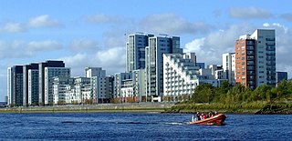
Glasgow Harbour is an urban regeneration scheme at Partick in the West End of the city of Glasgow, Scotland.

The Renfrew Ferry is a passenger ferry service linking the north and south banks of the River Clyde in Scotland. The service, operated by Clydelink without subsidy, crosses between Renfrew and Yoker, close to Glasgow City Centre and is the last Clyde crossing this far upstream.

Bridge Street railway station, now disused, was the original Glasgow terminus of the Glasgow and Paisley Joint Railway; jointly owned by the Glasgow, Paisley and Greenock Railway (GP&G), which later merged with the Caledonian Railway, and the Glasgow, Paisley, Kilmarnock and Ayr Railway (GPK&A), which became part of the Glasgow and South Western Railway.

The Glasgow Dental Hospital and School is a dental teaching hospital, situated in the Garnethill area of the city centre of Glasgow, Scotland.
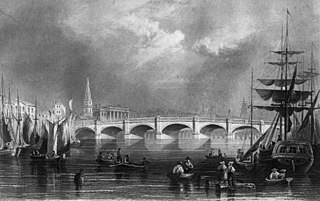
The Glasgow Bridge spans the River Clyde in Glasgow linking the city centre to Laurieston, Tradeston and Gorbals. Formerly known as Broomielaw Bridge, it is at the bottom of Jamaica Street near Central Station, and is colloquially known as the Jamaica Bridge.

Port Dundas is an area of Glasgow, Scotland, located 1 mile (1.6 km) to the north of the city centre. It lies to the north of Cowcaddens, and to the west of Sighthill, with Hamiltonhill and Possilpark to the north-west.

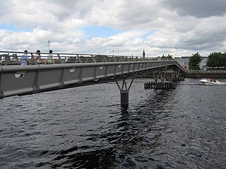
The Tradeston Bridge is a pedestrian bridge across the River Clyde in Glasgow which opened on 14 May 2009. It links the districts of Anderston to Tradeston and the neighbouring district of Kingston – the aim of the bridge being to aid the regeneration of Tradeston by giving it a direct link to the city's financial district on the western side of the city centre.
The Millennium Bridge is a pedestrian bridge over the River Clyde in the city of Glasgow, built as part of the millennium celebrations and funded by the Millennium Commission. The Bridge links the Scottish Exhibition and Conference Centre with the Glasgow Science Centre and Pacific Quay development to the south.
The City Union Bridge is a bridge on the River Clyde in Scotland. It was opened in 1899. It was once a busy main route in and out of St Enoch Station but that terminus closed in 1966 and was demolished in 1977, and since then the bridge is only used for empty stock movements, as the bridge forms a key link between Glasgow Queen St and Glasgow Central. If a project known as Glasgow Crossrail goes ahead then the bridge and associated track will see passenger services once more.

Victoria Bridge is a category A listed road bridge spanning the River Clyde in Glasgow, Scotland. Victoria Bridge is the oldest surviving bridge in Glasgow, lying at the foot of Stockwell Street in the city centre.

Auchenshuggle Bridge is a road bridge spanning the River Clyde in Glasgow, Scotland. The Auchenshuggle Bridge is the latest bridge to be built over the Clyde in the Auchenshuggle district of Glasgow, carrying the M74 motorway over the river and onto land which is part of Clydebridge Steelworks in Rutherglen, en route to the M8 junction near the heavily congested Kingston Bridge.

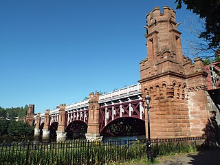
Albert Bridge is a road bridge spanning the River Clyde in Glasgow, Scotland near to Glasgow Green. The bridge, opened in 1871, links the Saltmarket in the city centre with Crown Street on the southside, is category A listed, and named after Queen Victoria's consort, Prince Albert.

King's Bridge is a road bridge spanning the River Clyde in Glasgow, Scotland. The bridge links Hutchesontown and Glasgow Green near the city centre.

Melville Dundas was a major Scottish construction company.

The South Portland Street Suspension Bridge is a suspension-type footbridge across the River Clyde in Glasgow, Scotland linking the City Centre on the north side to the Laurieston and Gorbals districts on the south side.
