The national nature reserves (NNRs) of Scotland are areas of land or water designated under the Wildlife and Countryside Act 1981 as containing habitats and species of national importance. National nature reserves can be owned by public, private, community or voluntary organisations but must be managed to conserve their important habitats and species, as well as providing opportunities for the public to enjoy and engage with nature. There are currently 43 NNRs in Scotland, which cover 154,250 hectares (1,542.5 km2), or less than 1.5% of the land area of Scotland. They range in size from Corrieshalloch Gorge at 7 ha to Mar Lodge Estate, which covers 29,324 ha.

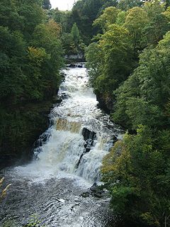
The Falls of Clyde is the collective name of four linn on the River Clyde near New Lanark, South Lanarkshire, Scotland. The Falls of Clyde comprise the upper falls of Bonnington Linn, Corra Linn, Dundaff Linn, and the lower falls of Stonebyres Linn. Corra Linn is the highest, with a fall of 26 metres (84 ft). Bonnington Linn, Corra Linn and Dundaff Linn are above New Lanark and located within the Falls of Clyde Reserve managed by the Scottish Wildlife Trust, a national nature conservation charity. Stonebyres Linn is located several miles downstream from the reserve and New Lanark.
The Clyde Walkway is a foot and mountain bike path which runs from Glasgow, Scotland, to just above the UNESCO World Heritage site of New Lanark. The path runs close to the River Clyde for most of its length. It was completed in 2005, and is now designated as one of Scotland's Great Trails by Scottish Natural Heritage. The route is 65 kilometres (40 mi) long, and combines rural sections on the upper Clyde in South Lanarkshire, including the Clyde Valley Woodlands National Nature Reserve and the Falls of Clyde, with urban walking through the centre of Glasgow. About 155,000 people use the path every year, of whom about 7,750 undertake multi-day journeys.

Glen Roy in the Lochaber area of the Highlands of Scotland is a glen or valley much of which is designated as a national nature reserve noted for the geological phenomenon of the three 'roads'. The "Parallel Roads" of Glen Roy are loch terraces that formed along the shorelines of an ancient ice-dammed loch. The loch existed during a brief period of climatic deterioration, during a much longer period of deglaciation, subsequent to the last main ice age. From a distance they resemble man-made roads running along the side of the Glen, hence the name.

Corrie Fee is a glacier-carved corrie situated at the head of Glen Clova in the Angus Glens of Scotland. It forms part of Corrie Fee National Nature Reserve (NNR), which is managed by Scottish Natural Heritage (SNH) and lies within the Cairngorms National Park. The adjoining Corrie Sharroch and the slopes of Craig Rennet are also included in the NNR.
Cleghorn covers a large area and is part of Lanark in South Lanarkshire, Scotland.it is in the catchment area of Lanark Grammar School. Cleghorn Village is a small close community with about 250–300 residents, and under 50 houses.

Ariundle Oakwood is situated to the north of the village of Strontian in the Sunart area of the Highlands of Scotland. It is located on the western side of the glen of the Strontian River, to the south of former lead mining sites that lie further up this glen. The wood is part of the ancient Sunart Oakwood, and is a remnant of ancient oakwoods that once spanned the Atlantic coasts of Europe from Norway to Portugal. It was designated as a National Nature Reserve in 1977, and is managed primarily by Scottish Natural Heritage, in conjunction with Forestry and Land Scotland, who own the land surrounding the National Nature Reserve. The reserve is classified as a Category IV protected area by the International Union for Conservation of Nature, and also forms part of both a Site of Special Scientific Interest and a Special Area of Conservation.

The Clyde Valley Woodlands National Nature Reserve (NNR) comprises six separate woodland sites in the Clyde Valley region of South Lanarkshire, Scotland. These six sites are located along a 12 km section of the River Clyde and its tributaries, and lie close to built-up areas such as Hamilton and Lanark on the southern outskirts of Greater Glasgow. The sites can be easily accessed by about two million people living in the surrounding urban areas, making the reserve unique amongst Scotland's NNRs, most of which tend to be located in more remote areas. The six sites are:

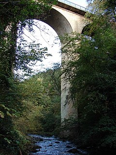
Nethan Gorge is a natural gorge carved by the River Nethan, located in South Lanarkshire, Scotland.
Mauldslie Woods is an area of woodland close to the town of Carluke, South Lanarkshire. It is one of six woodlands which form the Clyde Valley Woodlands National Nature Reserve, the others being Cartland Craigs, Chatelherault, Cleghorn Glen, Falls of Clyde and Lower Nethan Gorges.

Mouse Water is a river in South Lanarkshire which is a tributary of the River Clyde. It is popular with canoeists. In the past, the fast flowing river was used to power mills and factories along its route and is still used today to produce hydroelectricity.
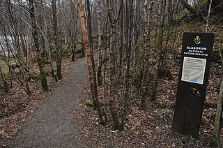
Glasdrum Wood is national nature reserve (NNR) at the head of Loch Creran in Argyll and Bute on the west coast of Scotland. Managed by Scottish Natural Heritage (SNH), the wood is renowned for its diverse flora and fauna, including sessile oak and ash trees, mosses, liverworts and rare invertebrates, like the chequered skipper butterfly. The NNR covers an area of around 169 hectares, encompassing woodland and hillside on the lower slopes of Beinn Churlain. SNH have provided a carpark, and constructed a 1 km-long waymarked trail for visitors. Since 2004 the reserve has received approximately 2800 visitors each year.

Glen Tanar is a glen in Aberdeenshire, eastern Scotland, through which the Water of Tanar flows. Near the mouth of the glen, at Tower o' Ess, the Water of Tanar flows into the River Dee. This flows through Deeside into the North Sea at Aberdeen. Glen Tanar contains the third largest area of Caledonian Forest in Scotland, and is of national and European importance.

The Upper Tweeddale National Scenic Area lies in the Borders region of Scotland. It is one of 40 national scenic areas (NSA) in Scotland, which are defined so as to identify areas of exceptional scenery and to ensure their protection from inappropriate development. The designated area covers 12,770 ha of countryside surrounding the upper reaches of the River Tweed between Broughton and Peebles.

Glen Nant is glen lying to the south of Taynuilt in the Argyll and Bute council area of Scotland. An area of woodland of 339 hectares on the western side of the River Nant is designated as national nature reserve (NNR), which is owned and managed by Forestry and Land Scotland (FLS). It is an example of an Atlantic Oakwood, and is one of largest areas of upland oak woodland in north Argyll.
Invereshie and Inshriach is a national nature reserve on the western flank of the Cairngorms in the Highland council area, Scotland. The reserve covers habitats at a range of different altitudes, ranging from Caledonian Forest beside the River Feshie in the west, via bog and open moorland, to an arctic-alpine environment on the Cairngorm plateau. The Munro summit of Sgòr Gaoith (1118 m) lies on the eastern boundary of the reserve. The forested areas of the reserve form part of an expanse of Caledonian pinewood that stretches from Glen Feshie to Abernethy, and which as a whole forms the largest single area of this habitat remaining in Scotland. The reserve is owned and managed jointly by Scottish Natural Heritage (SNH) and Forestry and Land Scotland (FLS): SNH own the Invereshie portion of the reserve and FLS the Inshriach area.