Cleghorn Glen

Last updated
Cleghorn Glen
formerly Cleghorn Glen National Nature Reserve
Cleghorn Glen 19 June 2010 (1).JPG
Sign at the entrance to the Cleghorn Glen Site of Special Scientific Interest
South Lanarkshire UK location map.svg
Red pog.svg
Cleghorn Glen shown within South Lanarkshire
Location South Lanarkshire, Scotland, United Kingdom
Nearest city Lanark
Coordinates 55°41′20.4″N3°46′4.8″W / 55.689000°N 3.768000°W / 55.689000; -3.768000 Coordinates: 55°41′20.4″N3°46′4.8″W / 55.689000°N 3.768000°W / 55.689000; -3.768000
Area41 hectares [1]
Established1953: Declared a site of special scientific interest
1981:Cleghorn Glen becomes a national nature reserve
1987:Cartland Craigs and Cleghorn Glen are declared constituent sites of the Clyde Valley Woodlands National Nature Reserve. [1]
Owner17 hectares: Scottish Natural Heritage
24 hectares: Mr Elliot-Lockhart [1]
www.nnr-scotland.org.uk/clyde-valley-woodlands/

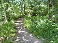
Cleghorn Glen is a site of special scientific interest which lies outside Lanark and Cleghorn in South Lanarkshire, Scotland. It is one of the six ancient woodlands, along with Cartland Craigs, Falls of Clyde, Chatelherault, Nethan Gorge and Mauldslie Woods, which make up the Clyde Valley Woodlands National Nature Reserve. [2]

Lanark town in Scotland

Lanark is a small town in the central belt of Scotland. The name is believed to come from the Cumbric Lanerc meaning "clear space, glade".

South Lanarkshire Council area of Scotland

South Lanarkshire is one of 32 unitary authorities of Scotland. It borders the south-east of the City of Glasgow and contains some of Greater Glasgow's suburbs. It also contains many towns and villages. It also shares borders with Dumfries and Galloway, East Ayrshire, East Renfrewshire, North Lanarkshire, the Scottish Borders and West Lothian. It includes part of the historic county of Lanarkshire.

Scotland Country in Northwest Europe, part of the United Kingdom

Scotland is a country that is part of the United Kingdom. It covers the northern third of the island of Great Britain, with a border with England to the southeast, and is surrounded by the Atlantic Ocean to the north and west, the North Sea to the northeast, the Irish Sea to the south, and more than 790 islands, including the Northern Isles and the Hebrides.

Birch genus of plants

A birch is a thin-leaved deciduous hardwood tree of the genus Betula, in the family Betulaceae, which also includes alders, hazels, and hornbeams. It is closely related to the beech-oak family Fagaceae. The genus Betula contains 30 to 60 known taxa of which 11 are on the IUCN 2011 Red List of Threatened Species. They are a typically rather short-lived pioneer species widespread in the Northern Hemisphere, particularly in northern areas of temperate climates and in boreal climates.

Related Research Articles

National nature reserve (Scotland)

The national nature reserves (NNRs) of Scotland are areas of land or water designated under the Wildlife and Countryside Act 1981 as containing habitats and species of national importance. National nature reserves can be owned by public, private, community or voluntary organisations but must be managed to conserve their important habitats and species, as well as providing opportunities for the public to enjoy and engage with nature. There are currently 43 NNRs in Scotland, which cover 154,250 hectares (1,542.5 km2), or less than 1.5% of the land area of Scotland. They range in size from Corrieshalloch Gorge at 7 ha to Mar Lodge Estate, which covers 29,324 ha.

Loch Lomond and The Trossachs National Park national park

Loch Lomond and The Trossachs National Park is a national park in Scotland centred on Loch Lomond and the hills and glens of the Trossachs, along with several other ranges of hills. It was the first of the two national parks established by the Scottish Parliament in 2002, the second being the Cairngorms National Park. The park consists of many mountains and lochs, and the principal attractions are scenery, walking, and wildlife.

Beinn Eighe mountain in the United Kingdom

Beinn Eighe is a complex mountain massif in the Torridon area of Wester Ross in the Highlands of Scotland. Lying to the south of Loch Maree, it forms a long ridge with many spurs and summits, two of which are classified as Munros. The name Beinn Eighe comes from the Scottish Gaelic meaning File Mountain. Unlike most other hills in the area it has a cap of Cambrian basal quartzite which gives the peaks of Beinn Eighe a distinctive light colour. Its complex topography has made it popular with both hillwalkers and climbers and the national nature reserve on its northern side makes it an accessible mountain for all visitors.

Falls of Clyde (waterfalls) group of waterfalls in Scotland, United Kingdom

The Falls of Clyde is the collective name of four linn on the River Clyde near New Lanark, South Lanarkshire, Scotland. The Falls of Clyde comprise the upper falls of Bonnington Linn, Corra Linn, Dundaff Linn, and the lower falls of Stonebyres Linn. Corra Linn is the highest, with a fall of 26 metres (84 ft). Bonnington Linn, Corra Linn and Dundaff Linn are above New Lanark and located within the Falls of Clyde Reserve managed by the Scottish Wildlife Trust, a national nature conservation charity. Stonebyres Linn is located several miles downstream from the reserve and New Lanark.

Clyde Walkway

The Clyde Walkway is a foot and mountain bike path which runs from Glasgow, Scotland, to just above the UNESCO World Heritage site of New Lanark. The path runs close to the River Clyde for most of its length. It was completed in 2005, and is now designated as one of Scotland's Great Trails by Scottish Natural Heritage. The route is 65 kilometres (40 mi) long, and combines rural sections on the upper Clyde in South Lanarkshire, including the Clyde Valley Woodlands National Nature Reserve and the Falls of Clyde, with urban walking through the centre of Glasgow. About 155,000 people use the path every year, of whom about 7,750 undertake multi-day journeys.

Creag Meagaidh 1128m high mountain in Scotland

Creag Meagaidh is a mountain on the northern side of Glen Spean in the Highlands of Scotland. It is a complex mountain, taking the form of a flat summit plateau from which five ridges radiate, and is most famed for the cliffs surrounding the corrie of Coire Ardair on the north-eastern face. These crags are a renowned venue for winter and ice climbing, although being somewhat vegetated they are less suited to summer climbing.

Cleghorn covers a large area and is part of Lanark in South Lanarkshire, Scotland.it is in the catchment area of Lanark Grammar School. Cleghorn Village is a small close community with about 250–300 residents, and under 50 houses.

Cartland Craigs

Cartland Craigs is a woodland on the outskirts of Lanark, South Lanarkshire, in Scotland. It is a national nature reserve and is one of six areas which together form the Clyde Valley Woodlands. The reserve is maintained by Scottish Natural Heritage.

Ariundle Oakwood

Ariundle Oakwood is situated to the north of the village of Strontian in the Sunart area of the Highlands of Scotland. It is located on the western side of the glen of the Strontian River, to the south of former lead mining sites that lie further up this glen. The wood is part of the ancient Sunart Oakwood, and is a remnant of ancient oakwoods that once spanned the Atlantic coasts of Europe from Norway to Portugal. It was designated as a National Nature Reserve in 1977, and is managed primarily by Scottish Natural Heritage, in conjunction with Forestry and Land Scotland, who own the land surrounding the National Nature Reserve. The reserve is classified as a Category IV protected area by the International Union for Conservation of Nature, and also forms part of both a Site of Special Scientific Interest and a Special Area of Conservation.

Clyde Valley Woodlands National Nature Reserve

The Clyde Valley Woodlands National Nature Reserve (NNR) comprises six separate woodland sites in the Clyde Valley region of South Lanarkshire, Scotland. These six sites are located along a 12 km section of the River Clyde and its tributaries, and lie close to built-up areas such as Hamilton and Lanark on the southern outskirts of Greater Glasgow. The sites can be easily accessed by about two million people living in the surrounding urban areas, making the reserve unique amongst Scotland's NNRs, most of which tend to be located in more remote areas. The six sites are:

Nethan Gorge

Nethan Gorge is a natural gorge carved by the River Nethan, located in South Lanarkshire, Scotland.

Mauldslie Woods

Mauldslie Woods is an area of woodland close to the town of Carluke, South Lanarkshire. It is one of six woodlands which form the Clyde Valley Woodlands National Nature Reserve, the others being Cartland Craigs, Chatelherault, Cleghorn Glen, Falls of Clyde and Lower Nethan Gorges.

Mouse Water river in the United Kingdom

Mouse Water is a river in South Lanarkshire which is a tributary of the River Clyde. It is popular with canoeists. In the past, the fast flowing river was used to power mills and factories along its route and is still used today to produce hydroelectricity.

Glasdrum Wood National Nature Reserve

Glasdrum Wood is national nature reserve (NNR) at the head of Loch Creran in Argyll and Bute on the west coast of Scotland. Managed by Scottish Natural Heritage (SNH), the wood is renowned for its diverse flora and fauna, including sessile oak and ash trees, mosses, liverworts and rare invertebrates, like the chequered skipper butterfly. The NNR covers an area of around 169 hectares, encompassing woodland and hillside on the lower slopes of Beinn Churlain. SNH have provided a carpark, and constructed a 1 km-long waymarked trail for visitors. Since 2004 the reserve has received approximately 2800 visitors each year.

Loch Lomond National Nature Reserve

Loch Lomond National Nature Reserve (NNR) encompasses 430 hectares of land at the southeastern part of Loch Lomond in the council areas of Stirling and West Dunbartonshire, in Scotland. It covers the islands of Inchcailloch, Clairinsh, Torrinch, Creinch and Aber Isle, alongside areas of woodland and wetlands to either side of the mouth of the Endrick Water. Scottish Natural Heritage (SNH) owns two parts of the reserve - the island of Inchcailloch and part of Gartfairn Wood - and the rest is privately owned. The reserve is managed by a partnership consisting of SNH, the Royal Society for the Protection of Birds (RSPB) and the Loch Lomond and The Trossachs National Park, along with the owners and tenants of the land under agreements. Within this framework SNH directly manage the islands of Clairinsh, Inchcailloch, Torrinch and Creinch, and land to the north of the Endrick Water. The RSPB manages the area to the south of the Endrick Water, and the National Park manages visitor facilities on Inchcailloch.

Craigellachie National Nature Reserve national nature reserve near Aviemore, Scotland

Craigellachie is a hill lying to the west of the village of Aviemore in Strathspey, in the central Highlands of Scotland. Craigellachie was declared a national nature reserve (NNR) in 1961, and is managed by Scottish Natural Heritage (SNH) through a lease from Reidhaven Estate. In addition to the birkwoods, the reserve also encompasses a variety of other habitats, such as rocky crags, lochans and open heath with blaeberry. The reserve covers 257 hectares on the eastern slopes of the Monadhliath range of hills, lying between 225 and 535 m above sea level. The reserve is dominated by birkwood, being one of the largest remaining areas of this type of habitat on Speyside. It is also of national importance due to the variety of moths present on the reserve.

Glen Tanar Glen of the Water of Tanar and national nature reserve in northeast Scotland

Glen Tanar is a glen in Aberdeenshire, eastern Scotland, through which the Water of Tanar flows. Near the mouth of the glen, at Tower o' Ess, the Water of Tanar flows into the River Dee. This flows through Deeside into the North Sea at Aberdeen. Glen Tanar contains the third largest area of Caledonian Forest in Scotland, and is of national and European importance.

Glen Nant Woodland and nature reserve in Argyll and Bute, Scotland

Glen Nant is glen lying to the south of Taynuilt in the Argyll and Bute council area of Scotland. An area of woodland of 339 hectares on the western side of the River Nant is designated as national nature reserve (NNR), which is owned and managed by Forestry and Land Scotland (FLS). It is an example of an Atlantic Oakwood, and is one of largest areas of upland oak woodland in north Argyll.

Invereshie and Inshriach National Nature Reserve

Invereshie and Inshriach is a national nature reserve on the western flank of the Cairngorms in the Highland council area, Scotland. The reserve covers habitats at a range of different altitudes, ranging from Caledonian Forest beside the River Feshie in the west, via bog and open moorland, to an arctic-alpine environment on the Cairngorm plateau. The Munro summit of Sgòr Gaoith (1118 m) lies on the eastern boundary of the reserve. The forested areas of the reserve form part of an expanse of Caledonian pinewood that stretches from Glen Feshie to Abernethy, and which as a whole forms the largest single area of this habitat remaining in Scotland. The reserve is owned and managed jointly by Scottish Natural Heritage (SNH) and Forestry and Land Scotland (FLS): SNH own the Invereshie portion of the reserve and FLS the Inshriach area.

Moine Mhòr Area of raised bog in Argyll and Bute, Scotland

Moine Mhòr encompasses a large area of raised bog in the Kilmartin Glen area of Argyll and Bute, Scotland. As well as raised bog there are areas of saltmarsh, brackish grassland, alder carr, fen and woodland, and the variety of habitats at Moine Mhòr provide important habitats for a variety of animal and plant species. The area was declared a National Nature Reserve (NNR) in 1987, and is now owned and managed by Scottish Natural Heritage (SNH). According to SNH lowland raised bogs like Moine Mhòr are some of the rarest and most threatened natural wildlife habitats in Europe, due to removal of peat, afforestation and reclamation of farmland.

References

  1. 1 2 3 "The Story of the Clyde Valley Woodlands National Nature Reserve" (PDF). Scotland's National Nature Reserves. Scottish Natural Heritage. Archived from the original (PDF) on 27 November 2014. Retrieved 22 January 2012.
  2. "Clyde Valley Woodlands". Scottish Natural Heritage. 2005. Retrieved 19 June 2010. DEAD LINK