Related Research Articles

Buachaille Etive Mòr, Scottish Gaelic: Buachaille Èite Mòr, 'great herdsman of Etive'), also known simply as 'The Buachaille', is a mountain at the head of Glen Etive in the Highlands of Scotland. Its pyramidal shape, as seen from the northeast, makes it one of the most recognisable mountains in Scotland, and one of the most depicted on postcards and calendars.

Sgùrr nan Gillean is a peak in the northern part of the Cuillin mountains on the Isle of Skye in Scotland. With a height of 966 metres, it is one of eleven Munros in the Cuillins. It is the Munro peak nearest to the settlement of Sligachan, and its impressive triangular profile makes it one of the most recognizable of the Cuillins.
Sgùrr Choinnich is a mountain with a height of 999 metres (3,278 ft) in the Northwest Highlands of Scotland. Classed as a Munro, it is in the Achnashellach Forest area between Glen Carron and Loch Monar. It has mostly steep, grassy slopes, with a narrow summit ridge that runs east–west. There are crags on the northern side of this ridge, looking down into the corrie of Coire Choinnich.

Beinn Dearg is the fourth highest of the Torridon Hills in the highlands of Scotland. Beinn Dearg offers all the typical features of a Torridon hill, with steeply terraced rocky sides dissected by near vertical gullies. The summit ridge is an airy crest that offers some easy scrambling; alternatively this can be avoided by following a path that traverses the terraces on the southern side.
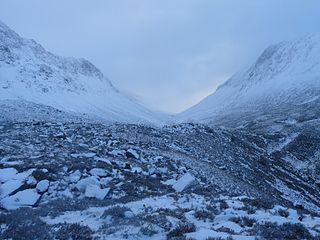
The Lairig Ghru is one of the mountain passes through the Cairngorms of Scotland. The route and mountain pass partially lies on the Mar Lodge Estate.
Achairn Burn, known also as Haster Burn, is one of the major tributaries of Wick River, in Caithness, in the Highland area of Scotland. The burn's source is in headwaters flowing from the northern slope of the Hill of Toftgunn, which rises to over 170 metres, and in Camster Loch, which is at nearly 120 metres, between the Hill of Toftgunn and Ballharn Hill. The same area feeds also another major tributary of Wick River, the Camster/Rowans-Strath Burn. Achairn Burn enters Wick River at Mary Ford, about 10 kilometres to the northeast of the burn's source. Its entire course is within Caithness, as is the whole of the catchment basin of Wick River.

Slioch is a mountain in the Scottish Highlands situated in Wester Ross, eight kilometres north of the village of Kinlochewe. Slioch reaches a height of 981 metres (3218 feet) and towers above the south east end of Loch Maree to give one of the best known and most photographed sights in the Highlands. VisitScotland, the Scottish national tourist agency, has used video footage of Slioch in its television advertisements.
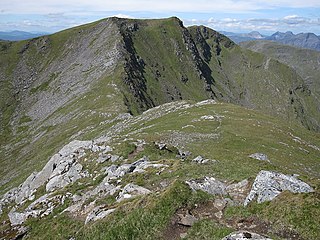
Stob Coire a’ Chàirn is a Scottish mountain situated in the Mamores range, 3.5 kilometres north of Kinlochleven. The mountain reaches a height of 981 metres (3218 feet) and is regarded as one of the more modest peaks of the ten Munros in the Mamores, indeed for many years it was not named on OS maps. Despite this, it is situated at a strategically important point and could be said to be the most central of the group with three ridges radiating out to other Munros. The mountains name translates from Gaelic as “Peak of the Corrie of the Cairn”.

Sgùrr na Ciste Duibhe or Sgùrr nan Cisteachan Dubha is a mountain in the Northwest Highlands of Scotland, one of the 'Five Sisters of Kintail'. It is on the northern side of Glen Shiel, 27 kilometers southeast of Kyle of Lochalsh. Its height is 1,027 metres (3,369 ft) and it is classed as a Munro.

Mòruisg is a Scottish mountain situated in the Glencarron and Glenuig Forest, 10 kilometres south west of the village of Achnasheen in the Highland council area.
Glen Lui from Gleann Laoigh – calves' glen – Gordon (1925) is one of the major glens on the Mar Lodge Estate, in Aberdeenshire, Scotland.

Càrn Mairg is a mountain in the Breadalbane region of the Scottish Highlands, with a height of 1,042 metres (3,419 ft). It stands in a group of four Munro mountains known as the 'Càrn Mairg group', on the north side of Glen Lyon, Perthshire.

Chno Dearg is a mountain in the Lochaber area of the Scottish Highlands. It overlooks Glen Spean to the north and Loch Treig to the west. With a height of 1,046 metres (3,432 ft), it is classed as a Munro.
Sgairneach Mhòr is a Scottish mountain which lies in a group of seven Munros near the summit of the Pass of Drumochter and are known as the Drumochter mountains or informerly as the “A9 Munros”. The mountain is situated 13 km SSW of Dalwhinnie and four km east of the large Loch Ericht.

Beinn a' Chaorainn is a Scottish mountain situated on the northern side of Glen Spean in the Lochaber region of the Highland Council area. The mountain which is located 30 km east-northeast of Fort William is one of several of the same name in the Scottish Highlands and should not be confused with another well known Beinn a' Chaorainn in the Cairngorms.
Easan Labhar is a series of waterfalls on the island of Mull, Scotland. It lies on the Allt an Easain Labhair near Gruline west of Salen. There are also unnamed waterfalls on the Allt na Linne burn just to the east.

The River Garry is a major tributary of the River Tummel, itself a tributary of the River Tay, in the traditional county of Perthshire in the Scottish Highlands. It emerges from the northeastern end of Loch Garry (56.8193°N 4.2311°W), just to the southeast of the Pass of Drumochter, and flows southeastwards and eastwards down Glen Garry to the narrow Pass of Killiecrankie beyond which it joins the Tummel (56.7182°N 3.7790°W).

The River Feshie is a major right bank tributary of the River Spey in north-east Scotland. It rises in the remote countryside of the Glenfeshie Forest, flowing initially eastwards before turning sharply to the northwest as a result of the capture of the waters of Geldie Burn. After gaining the waters of the River Eidart on its right bank and dropping down into Glen Feshie, it flows northwards through the wooded glen and is often braided in nature. It is joined by several burns which descend steeply from the Cairngorm plateau to the east and, on its left bank, by the Allt Chomhraig near Balachroick. The river passes beneath the B970 road at Feshiebridge and after a further 1.5 miles (2.5 km) it joins the Spey near the village of Kincraig.

The Lairig an Laoigh is a mountain pass through the Highlands of Scotland. In speech and sometimes in writing the name is reduced to "Lairig Laoigh". It is of glacial origin, dissecting the Cairngorm plateau, and it runs roughly north–south from Speyside to Deeside at one time being used as a drove road. Between the public road in the Abernethy Forest and the one at Linn of Dee the trekking distance is 31 kilometres (19 mi).
Allt a' Chaol Ghlinne—also spelled Allt a' Chaol-ghlinne—is a river in the Lochaber area of Highland, Scotland. Located in a glen (valley) within the Northwest Highlands of the Scottish Highlands, Allt a' Chaol Ghlinne is a tributary to the River Finnan, which itself flows into Loch Shiel.
References
Coordinates: 57°03′21″N3°04′06″W / 57.05595°N 3.06836°W