
Loch Lomond is a freshwater Scottish loch which crosses the Highland Boundary Fault, often considered the boundary between the lowlands of Central Scotland and the Highlands. Traditionally forming part of the boundary between the counties of Stirlingshire and Dunbartonshire, Loch Lomond is split between the council areas of Stirling, Argyll and Bute and West Dunbartonshire. Its southern shores are about 23 kilometres (14 mi) northwest of the centre of Glasgow, Scotland's largest city. The Loch forms part of the Loch Lomond and The Trossachs National Park which was established in 2002.

The Stirling council area is one of the 32 council areas of Scotland, and has a population of about 94,330. It was created under the Local Government etc (Scotland) Act 1994 with the boundaries of the Stirling district of the former Central local government region, and it covers most of Stirlingshire and the south-western portion of Perthshire. Both counties were abolished for local government purposes under the Local Government (Scotland) Act 1973.

The Lennox is a region of Scotland centred on The Vale of Leven, including its great loch: Loch Lomond.

Inchmurrin is an island in Loch Lomond in Scotland. It is the largest fresh water island in the British Isles.

The Lomond Hills, also known outwith the locality as the Paps of Fife, are a range of hills in central Scotland. They lie in western central Fife and Perth and Kinross, Scotland. At 522 metres (1,713 ft) West Lomond is the highest point in the county of Fife.
Beinn Chùirn is a Scottish hill situated five kilometres west-southwest of Tyndrum, it stands on the border of Stirlingshire and Perthshire at the northern extremity of the Loch Lomond and the Trossachs National Park.

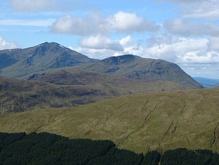
Ben Oss is a Scottish mountain situated in the Stirling Council area, six kilometres south west of the village of Tyndrum within the Loch Lomond and the Trossachs National Park.

Dumbarton was a local government district in the Strathclyde region of Scotland from 1975 to 1996, lying to the north-west of the regional capital Glasgow.

Balfron High School is a secondary school situated in the village of Balfron, approximately 18 miles (29 km) west of Stirling and 16 miles (26 km) north of Glasgow. The catchment area extends over most of West Stirlingshire including the villages of Arnprior, Balfron, Balmaha, Blanefield, Buchlyvie, Croftamie, Drymen, Fintry, Killearn, Kippen, Milton of Buchanan and Strathblane, along with the hamlets of Balfron Station, Boquhan, Buchanan Smithy, Gartness and Mugdock. The school also has pupils attending from other nearby areas of Dunbartonshire and Stirlingshire.

Aber Isle or Aber Inch is a small island in Loch Lomond, in west central Scotland. It is near the mouth of the River Endrick, by the abandoned village of Aber, and is 1⁄2 mile from Clairinch. Its name derives from the Celtic word for the mouth of a river, or Gaelic eabar meaning "mud, mire".
The Gargunnock Hills are a range of hills west of the city of Stirling, Scotland. They culminate in the peak of Carleatheran, whose 485-metre (1,591 ft) summit is crowned by a trigonometrical pillar. The Gargunnock Hills are separated from the Fintry Hills to their west by the valley of the Backside Burn. To their east are the Touch Hills, whilst to the south is Carron Valley Reservoir.

The Fintry Hills form the western end of a range of hills which stretch west from the city of Stirling, Scotland. They culminate in the 511-metre (1,677 ft) peak of Stronend, which overlooks Strathendrick and the village of Fintry.
Glen Douglas is a glen in the southwest Scottish Highlands. It is drained by the Douglas Water, which discharges at the village of Inverbeg at its eastern end into Loch Lomond. The glen is followed by a single-track road which links the A82 road alongside Loch Lomond with the A814 road beside Loch Long. The glen is overlooked to the north by Beinn Bhreac and Tullich Hill and to the south by Doune Hill and a 655 m (2,149 ft) hill known as Coire na h-Eanachan.

The Douglas Water is a river in Argyll in the southwest Scottish Highlands. It emerges from the northeastern end of the diminutive Loch Dubh-ghlas (56.2019°N 5.2134°W) and flows northeastwards through Coire Dubh-ghlas, before turning east then southeast amongst extensive conifer plantations to the bridge which carries the A83 road over it. It then turns east at this point and flows into the tidal Loch Fyne (56.1963°N 5.1086°W).

The River Garry is a major tributary of the River Tummel, itself a tributary of the River Tay, in the traditional county of Perthshire in the Scottish Highlands. It emerges from the northeastern end of Loch Garry (56.8193°N 4.2311°W), just to the southeast of the Pass of Drumochter, and flows southeastwards and eastwards down Glen Garry to the narrow Pass of Killiecrankie beyond which it joins the Tummel (56.7182°N 3.7790°W).

Blanefield is a settlement contiguous with Strathblane's northwestern fringe. To the west is the volcanic plug Dumgoyne, Glengoyne Distillery and the Trossachs National Park. The West Highland Way—a long-distance trail—passes close to the village.
The Inverarnan Canal was a short length of canal terminating at Garbal, close to the hamlet of Inverarnan, Scotland. This waterway once linked the old coaching inn, now the Drovers Inn, at Inverarnan, on the Allt Arnan Burn to the River Falloch and passengers could continue southward to Loch Lomond and finally to Balloch. From Inverarnan stagecoaches ran to various destinations in the north of Scotland.

Loch Lomond National Nature Reserve (NNR) encompasses 430 hectares of land at the southeastern part of Loch Lomond in the council areas of Stirling and West Dunbartonshire, in Scotland. It covers the islands of Inchcailloch, Clairinsh, Torrinch, Creinch and Aber Isle, alongside areas of woodland and wetlands to either side of the mouth of the Endrick Water. Scottish Natural Heritage (SNH) owns two parts of the reserve - the island of Inchcailloch and part of Gartfairn Wood - and the rest is privately owned. The reserve is managed by a partnership consisting of SNH, the Royal Society for the Protection of Birds (RSPB) and the Loch Lomond and The Trossachs National Park, along with the owners and tenants of the land under agreements. Within this framework SNH directly manage the islands of Clairinsh, Inchcailloch, Torrinch and Creinch, and land to the north of the Endrick Water. The RSPB manages the area to the south of the Endrick Water, and the National Park manages visitor facilities on Inchcailloch.
