| Barry Burn Pitairlie Burn | |
|---|---|
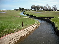 Barry Burn at the Burnside Golf Course, Carnoustie | |
 | |
| Location | |
| Country | Scotland |
| Physical characteristics | |
| Source | Dodd Hill |
| • location | Sidlaw Hills, Angus, UK |
| • coordinates | 56°32′36.6504″N2°52′29.6724″W / 56.543514000°N 2.874909000°W |
| • elevation | 195 m (640 ft) |
| Mouth | Carnoustie Golf Links, North Sea |
• location | Carnoustie, UK |
• coordinates | 56°29′39.1884″N2°42′58.4166″W / 56.494219000°N 2.716226833°W |
• elevation | 0 m (0 ft) |
The Barry Burn, otherwise known as Pitairlie Burn is a minor river in Angus, Scotland. It rises in the eastern portion of the Sidlaw Hills and flows past Newbigging, through Barry and the western part of Carnoustie, before taking a meandering course through Carnoustie Golf Links. [1]
The burn passes (and is the power source for) Barry Mill, one of only two remaining water-powered mills in Scotland, now owned by the National Trust for Scotland.