The River Avon is a river in the Strathspey area of the Scottish Highlands, and a tributary of the River Spey. It drains the north-eastern area of the Cairngorm Mountains and is largely contained within the Cairngorms National Park

The Caledonian Canal connects the Scottish east coast at Inverness with the west coast at Corpach near Fort William in Scotland. The canal was constructed in the early nineteenth century by Scottish engineer Thomas Telford.
Loch Linnhe is a sea loch on the west coast of Scotland. The part upstream of Corran is known in Gaelic as An Linne Dhubh, and downstream as An Linne Sheileach. The name Linnhe is derived from the Gaelic word linne, meaning "pool".

The Great Glen, also known as Glen Albyn or Glen More, is a glen in Scotland running for 62 miles (100 km) from Inverness on the edge of the Moray Firth, in an approximately straight line to Fort William at the head of Loch Linnhe. It follows a geological fault known as the Great Glen Fault, and bisects the Scottish Highlands into the Grampian Mountains to the southeast and the Northwest Highlands to the northwest.

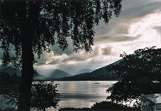
Loch Lochy is a large freshwater loch in Lochaber, Highland, Scotland. With a mean depth of 70 m (230 ft), it is the third-deepest loch of Scotland.
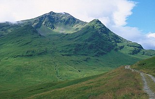
Ben Lui is a mountain in the southern Highlands of Scotland. It is a Munro with a height of 1,130 metres (3,710 ft). Ben Lui is in northeast Argyll and is the highest peak of a mountain chain that includes three other Munros. It has five well-defined ridges radiating out from the summit. Four corries lie between the ridges, including Coire Gaothaich on the northeast side of the mountain.
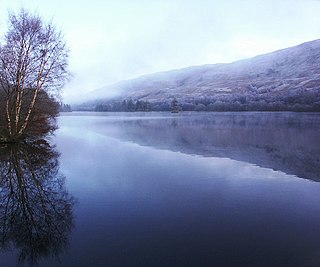
Loch Oich is a freshwater loch in the Highlands of Scotland which forms part of the Caledonian Canal, of which it is the highest point. This narrow loch lies between Loch Ness and Loch Lochy in the Great Glen. It is fed by the River Garry from the west, and feeds the River Oich from its northern end. The Laggan locks separate it from Loch Lochy.

The Battle of the Shirts was a Scottish clan battle that took place in 1544 in the Great Glen, at the northern end of Loch Lochy. The Clan Macdonald of Clanranald and their allies the Clan Cameron fought the Clan Fraser and men from Clan Grant. The battlefield has been included and protected by Historic Scotland in their Inventory of Historic Battlefields in Scotland.

The Great Glen Way is a long distance path in Scotland. It follows the Great Glen, running from Fort William in the southwest to Inverness in the northeast, covering 125 kilometres (78 mi). It was opened in 2002, and is designated as one of Scotland's Great Trails by NatureScot. The Great Glen Way is generally walked from southwest to northeast to follow the direction of the prevailing wind. It can be walked in 5–7 days, or cycled in 2–3 days. The trail is maintained and improved by the Great Glen Ways partnership, which consists of Highland Council, Scottish Canals and Forestry and Land Scotland. About 30,000 people use the path every year, of whom about 4,500 complete the entire route.

Loch Arkaig is a body of freshwater in Lochaber, Scotland, to the west of the Great Glen. It is approximately 12 miles in length and lies 140 feet above sea level, the maximum depth is around 300 feet

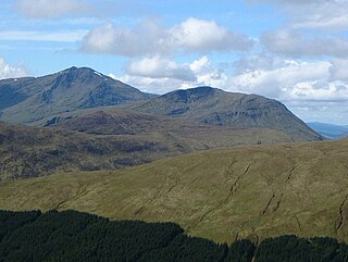
Sròn a’ Choire Ghairbh is a Scottish mountain situated on the northern side of Loch Lochy, 13 kilometres north of Spean Bridge in the Highland Council area.

Meall na Teanga is a Scottish mountain located in the Highland council area, 11 km (7 mi) north of Spean Bridge.
Beinn Chùirn is a hill five kilometres west-south-west of Tyndrum, Scotland, standing on the border of Stirlingshire and Perthshire at the northern extremity of the Loch Lomond and The Trossachs National Park.

Ben Tee is a Scottish mountain situated in the Lochaber area of the Highland council area, some 15 kilometres north of Spean Bridge. It is rated as one of the best of Scotland's smaller mountains with Hamish Brown saying:
Ben Tee is such a shapely cone that it is instantly recognisable from anywhere around the Great Glen or along the Garry. Its isolated situation makes it one of Scotland’s finest summit viewpoints.
National Cycle Route 78 runs from Campbeltown to Inverness. It was officially launched as the Caledonia Way in 2016 as part of the wider redevelopment of Scotland's cycle network. It runs from the Kintyre peninsula to the Great Glen and the route varies from on road to traffic-free forest trails and canal paths.

Gairlochy(Scottish Gaelic: Geàrr Lòchaidh) is a clachan, or hamlet, of population approx. 100. It lies on the southern shores of Loch Lochy, a large freshwater loch in the district of Lochaber in the North West Highlands of Scotland. Gairlochy is surrounded by several other small crofting settlements, the largest of which is Achnacarry. Also close by is Highbridge, the site of the first skirmish of the 1745 Jacobite uprising.
Clunes is a small hamlet, located on the west shore of Loch Lochy, less than 0.5 miles northeast of Bunarkaig in Inverness-shire, Scottish Highlands and is in the Highland council area of Scotland.

The River Spean flows from Loch Laggan in a westerly direction to join the River Lochy at Gairlochy in the Great Glen in the West Highlands of Scotland. Major tributaries of the Spean include the left-bank Abhainn Ghuilbinn and River Treig, the right-bank River Roy and the left-bank river known as The Cour. The river is accompanied by the A86 road for almost its entire length, running from (upper) Loch Laggan west to Spean Bridge. The river is spanned by a bridge carrying the A82 road near its junction with the A86 at Spean Bridge. A minor road bridges the Spean just above the falls at Inverlair. Two further road crossings exist - a private estate road across the short stretch of river between upper Loch Laggan and the Laggan reservoir and a road traversing the top of Laggan Dam. The West Highland Line crosses the river near Tulloch Station and follows its north bank before re-crossing one mile east of Spean Bridge. A branch of the railway formerly continued west beside the river from Spean Bridge, crossing it once again to the west of the village.

The River Lochy flows southwest along the Great Glen from Loch Lochy to Loch Linnhe at Fort William in the West Highlands of Scotland. Its two major tributaries are the short River Arkaig which drains Loch Arkaig into Loch Lochy and the River Spean which enters on its left bank at Gairlochy. The A830 road crosses the Lochy near its junction with the A82 road by means of the Victoria or Lochy Bridge just northeast of Fort William and the river is bridged again east of Gairlochy by the B8004 road. The only other crossing of the Lochy is a combined rail and foot bridge 500 metres (1,600 ft) downstream from Victoria Bridge. This span takes the West Highland Line between Fort William and Mallaig and carries the Great Glen Way national trail.