
Fort William is a town in Lochaber in the Scottish Highlands, located on the eastern shore of Loch Linnhe. As of the 2011 Census, Fort William had a population of 10,459, making it the second largest settlement in the Highland council area, and the second largest settlement in the whole of the Scottish Highlands; only the city of Inverness has a larger population.

The West Highland Way is a linear long-distance route in Scotland. It is 154 km long, running from Milngavie north of Glasgow to Fort William in the Scottish Highlands, with an element of hill walking in the route. The trail, which opened in 1980, was Scotland's first officially designated Long Distance Route, and is now designated by NatureScot as one of Scotland's Great Trails. It is primarily intended as a long distance walking route, and whilst many sections are suitable for mountain biking and horseriding there are obstacles and surfaces that will require these users to dismount in places.

Glencoe or Glencoe Village is the main settlement in Glen Coe in the Lochaber area of the Scottish Highlands. It lies at the north-west end of the glen, on the southern bank of the River Coe where it enters Loch Leven.
The A82 is a major road in Scotland that runs from Glasgow to Inverness via Fort William. It is one of the principal north-south routes in Scotland and is mostly a trunk road managed by Transport Scotland, who view it as an important link from the Central Belt to the Scottish Highlands and beyond. The road passes close to numerous landmarks, including; Loch Lomond, Rannoch Moor, Glen Coe, the Ballachulish Bridge, Ben Nevis, the Commando Memorial, Loch Ness, and Urquhart Castle.

The Great Glen, also known as Glen Albyn or Glen More, is a glen in Scotland running for 62 miles (100 km) from Inverness on the edge of Moray Firth, in an approximately straight line to Fort William at the head of Loch Linnhe. It follows a geological fault known as the Great Glen Fault, and bisects the Scottish Highlands into the Grampian Mountains to the southeast and the Northwest Highlands to the northwest.

Glen Nevis is a glen in Lochaber, Highland, Scotland, with Fort William at its foot. It is bordered to the south by the Mamore range, and to the north by the highest mountains in the British Isles: Ben Nevis, Càrn Mor Dearg, Aonach Mòr, and Aonach Beag. It is home to one of the three highest waterfalls in Scotland, Steall Falls, where the Allt Coire a'Mhail joins the Water of Nevis in the glen. Below the waterfall is a steeply walled and impressive gorge. The scenic beauty of the glen has led to its inclusion the Ben Nevis and Glen Coe National Scenic Area, one of 40 such areas in Scotland.

The Great Glen Way is a long distance path in Scotland. It follows the Great Glen, running from Fort William in the southwest to Inverness in the northeast, covering 125 kilometres (78 mi). It was opened in 2002, and is designated as one of Scotland's Great Trails by NatureScot. The Great Glen Way is generally walked from southwest to northeast to follow the direction of the prevailing wind. It can be walked in 5–7 days, or cycled in 2–3 days. The trail is maintained and improved by the Great Glen Ways partnership, which consists of Highland Council, Scottish Canals and Forestry and Land Scotland. About 30,000 people use the path every year, of whom about 4,500 complete the entire route.

An Gearanach is a Scottish mountain situated in the Mamore Forest, five and a half kilometres north of Kinlochleven in the Lochaber region of the Highland council area.

Sgùrr a' Mhàim is a Scottish mountain situated 5.5 kilometres (3.4 mi) north north-west of Kinlochleven in the Lochaber region of the Highland area.

The Mamores are a group of mountains in the Lochaber area of the Grampian Mountains in the Scottish Highlands. They form an east–west ridge approximately fifteen kilometres in length lying between Glen Nevis to the north and Loch Leven to the south.

Am Bodach is a Scottish mountain which lies in the Mamores range, four kilometres north of Kinlochleven in the Highland council area.
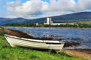
Achaphubuil is a small settlement to the north of Ardgour in Lochaber, in the Highlands of Scotland. Achaphubuil lies to the south of The Narrows, which link Loch Linnhe to Loch Eil. The village of Corpach is on the opposite shore, with Fort William across Loch Linnhe to the north-east.

Nevis Community Radio Ltd is a community radio station broadcasting from Fort William in Scotland, serving the communities of Fort William and the surrounding region of Lochaber including Fort Augustus, Mallaig, Glen Coe, Kinlochleven and parts of the Isle of Skye.
Stob Bàn is a mountain situated in the Lochaber region of Highland, Scotland, 16 kilometres east of Fort William. It reaches a height of 977 metres (3205 feet) and lies in a group of hills known as the Grey Corries which includes three other Munros and nine Munro "Tops" along an eight kilometre ridge. The mountain's name translate as “White Peak”, while other sources give the translation as Light Coloured Peak with the hill being covered in light coloured schist scree, in contrast to the rest of the Grey Corries which are made up of grey quartzite scree. The mountain is a prominent conical shape, isolated from the rest of the group and distant from any main roads. It should not be confused with another Munro named Stob Bàn situated in the Mamores.

Sròn a’ Choire Ghairbh is a Scottish mountain situated on the northern side of Loch Lochy, 13 kilometres north of Spean Bridge in the Highland Council area.
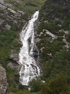
The spectacular waterfall known variously as An Steall Bàn, Steall Waterfall or Steall Falls is situated in Glen Nevis near Fort William, Highland, Scotland. It is Scotland's second-highest waterfall, and also the second highest in the United Kingdom, with a single drop of 120 metres. The fall can be viewed from the path that runs through the Nevis Gorge, an area owned by the John Muir Trust which manages the area for its wilderness qualities. An Steall Bàn means "The White Spout" in Gaelic
The Lochaber hydroelectric scheme is a hydroelectric power generation project constructed in the Lochaber area of the western Scottish Highlands after the First World War. Like its predecessor at Kinlochleven, it was intended to provide electricity for aluminium production, this time at Fort William, a little further north. It is still in operation.

Skyline Scotland is a set of annual skyrunning races which take place on consecutive days in the mountains around Kinlochleven in Lochaber. The main races are the Mamores VK, the Ring of Steall Skyrace, the Ben Nevis Ultra and the Glen Coe Skyline.

The River Lochy flows southwest along the Great Glen from Loch Lochy to Loch Linnhe at Fort William in the West Highlands of Scotland. Its two major tributaries are the short River Arkaig which drains Loch Arkaig into Loch Lochy and the River Spean which enters on its left bank at Gairlochy. The A830 road crosses the Lochy near its junction with the A82 road by means of the Victoria or Lochy Bridge just northeast of Fort William and the river is bridged again east of Gairlochy by the B8004 road. The only other crossing of the Lochy is a combined rail and foot bridge 500 metres (1,600 ft) downstream from Victoria Bridge. This span takes the West Highland Line between Fort William and Mallaig and carries the Great Glen Way national trail.

Ben Nevis and Glen Coe is a national scenic area (NSA) covering part of the Highlands of Scotland surrounding Ben Nevis and Glen Coe, in which certain forms of development are restricted. It is one of 40 such areas in Scotland, which are defined so as to identify areas of exceptional scenery and to ensure its protection from inappropriate development. The Ben Nevis and Glen Coe NSA covers 903 km2 (349 sq mi) of land, lying within the Highland, Argyll and Bute and Perth and Kinross council areas. A further 19 km2 (7.3 sq mi) of the NSA are marine, covering the sea loch of Loch Leven.

