


The River Gaur (Scottish Gaelic : Gamhair / Uisge Ghamhair) is a river in Perthshire which enters Loch Rannoch. [1]
The River Gaur (Scottish Gaelic : Gamhair / Uisge Ghamhair) is a river in Perthshire which enters Loch Rannoch. [1]
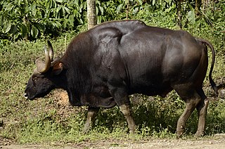
The gaur is a large bovine native to South Asia and Southeast Asia, and has been listed as Vulnerable on the IUCN Red List since 1986. The global population was estimated at a maximum of 21,000 mature individuals in 2016, with the majority of those existing in India.

The Pass of Drumochter meaning simply 'high ridge' is the main mountain pass between the northern and southern central Scottish Highlands. The A9 road passes through here, as does the Highland Main Line, the railway between Inverness and the south of Scotland. The Sustrans National Cycle Route 7 between Glasgow and Inverness also runs through the pass.

The River Leven is a stretch of water in West Dunbartonshire, Scotland, flowing from Loch Lomond in the North to the River Clyde in the South. The river is about 6 miles long. It is very popular with salmon and sea trout anglers, trying to catch one of these migratory fish going up to Loch Lomond.

The River Leven is a river in Fife, Scotland. It flows from Loch Leven into the Firth of Forth at the town of Leven. The river is home to brown trout and hosts a run of sea trout and atlantic salmon. The estuary has bass and mullet.

Finlarig Castle is an early 17th-century castle standing on a mound on a peninsula between the River Lochay and Loch Tay, just over 1⁄2 mile (0.80 km) north of Killin in Stirling, Scotland.

Highbridge is located on the River Spean, 2 kilometres (1.2 mi) downstream from the village of Spean Bridge in the Scottish Highlands. The village takes its name from this bridge.
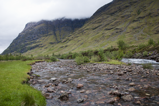
The River Coe rises at the north-eastern base of Buachaille Etive Beag in Scotland and flows west along Glen Coe. After dramatic waterfalls at the Pass of Glen Coe, it runs through the small Loch Achtriochtan before it turns north west. It then runs past the site of the Massacre of Glencoe and passes through Glencoe village, shortly before flowing into the sea loch of Loch Leven at Invercoe.

The River Dochart is in Perthshire, Scotland.
Glen Dochart in Perthshire, Scottish Highlands is a glen which runs from Crianlarich eastwards to Killin, following the course of the River Dochart as it flows through Loch Dochart and Loch Iubhair. It is met by Glen Ogle at Lix Toll. Lochan Saorach lies within the glen and was once famous for its Floating island.

The Endrick Water or River Endrick is a river which flows into the eastern end of Loch Lomond, Scotland.
Forgan is a civil parish in the Scottish county of Fife. It extends 4 miles in length along the north coast of Fife and is at the southern mouth of the River Tay. It is bounded by the other Fife civil parishes of Ferry-Port on Craig, Leuchars and Balmerino. It contains the towns of Newport-on-Tay and Wormit. The roads and railways leading to the Tay Bridges pass through the parish.

Garbh Uisge is a river of approximately 7 km in the Trossachs of Scotland just north-west Callander. It is the outflow of Loch Lubnaig and joins with Eas Gobhain west of Callander to form the River Teith. The name of the river, Garbh Uisge, is Gaelic for "Rough Water", reflecting the nature of the river. The river is often informally called the River Leny due to the Falls of Leny, where the river crosses the Highland Boundary Fault, and because it flows through the Pass of Leny.

Beinn a' Chreachain is a Scottish mountain, with a conical top, to the north-west of Loch Lyon.

Aber Isle or Aber Inch is a small island in Loch Lomond, in west central Scotland. It is near the mouth of the River Endrick, by the abandoned village of Aber, and is 1⁄2 mile from Clairinch. Its name derives from the Celtic word for the mouth of a river, or Gaelic eabar meaning "mud, mire".

The River Almond is a tributary of the River Tay in Perth and Kinross, Scotland. It rises in the hills to the south-east of Loch Tay, and flows eastwards through Glenalmond. It runs through the village of Almondbank, before joining the Tay immediately north of Perth. The river's course is around 48 kilometres (30 mi) long
The River Balvaig is a short river, approximately 8 km (5.0 mi) long, draining from the head of Loch Voil near Balquhidder in Scotland and then passing southwards through the village of Strathyre before flowing into the northern end of Loch Lubnaig.
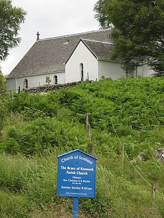
Braes of Rannoch is a hill with a deserted hamlet and church in Perthshire. The hamlet was formerly, briefly, called Georgetown, as the redcoat barracks of Jacobite rising of 1745 were then known, then known as Bridge of Rannoch, or Bridge of Gaur, after the bridge on the River Gaur. The original barracks have gone but a large house and shooting lodge, Rannoch Barracks, is named after them. The Braes of Rannoch Manse became a hostel for forestry workers by the 1970s. The church is today a tourist feature on the road from Kinloch Rannoch to Rannoch Station.
Defence Munitions Crombie is a military munitions depot on the upper Firth of Forth in West Fife, Scotland. The depot is located on the north shore of the river, south of the village of Crombie and west of Charlestown. The site commenced operations in 1916. It was formerly known as RNAD Crombie and DMC Crombie. It is now operated as part of the UK's Defence Storage and Distribution Agency.
Bugaba is a corregimiento in Bugaba District, Chiriquí Province, Panama. It has a land area of 12.9 square kilometres (5.0 sq mi) and had a population of 3,718 as of 2010, giving it a population density of 288.6 inhabitants per square kilometre (747/sq mi). Its population as of 1990 was 1,989; its population as of 2000 was 2,817.

Loch Moidart is a sea loch in the district of Moidart in the Scottish Highlands. It is on the west coast of Scotland, and runs about 8 km eastward from the sea. It is connected to the sea by two narrow channels which are separated by the island of Eilean Shona, which in turn is nearly split in two by a narrow isthmus. The River Moidart enters the loch at its head, near the hamlet of Ardmolich. Various views of the loch have featured as an Apple TV screensaver since 2021.
56°40′46″N4°28′47″W / 56.6795°N 4.4797°W
| | This Perth and Kinross location article is a stub. You can help Wikipedia by expanding it. |