
Argyll and Bute is one of 32 unitary council areas in Scotland and a lieutenancy area. The current lord-lieutenant for Argyll and Bute is Jane Margaret MacLeod. The administrative centre for the council area is in Lochgilphead at Kilmory Castle, a 19th-century Gothic Revival building and estate. The current council leader is Councillor Jim Lynch.

The A83 is a major road in the south of Argyll and Bute, Scotland, running from Tarbet, on the western shore of Loch Lomond, where it splits from the A82, to Campbeltown at the southern end of the Kintyre peninsula. The road is best known for its section across the Rest and be Thankful pass through the Arrochar Alps between the heads of Loch Long and Loch Fyne.
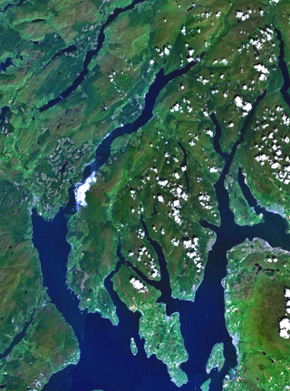
Cowal is a rugged peninsula in Argyll and Bute, on the west coast of Scotland. It is connected to the mainland to the north, and is bounded by Loch Fyne to the west, by Loch Long and the Firth of Clyde to the east, and by the Kyles of Bute to the south.

Loch Fyne, is a sea loch off the Firth of Clyde and forms part of the coast of the Cowal Peninsula. Located on the west coast of Argyll and Bute, west of Scotland. It extends 65 kilometres (40 mi) inland from the Sound of Bute, making it the longest of the sea lochs in Scotland. It is connected to the Sound of Jura by the Crinan Canal. Although there is no evidence that grapes have grown there, the title is probably honorific, indicating that the river, Abhainn Fìne, was a well-respected river.

Loch Lomond and The Trossachs National Park is a national park in Scotland centred on Loch Lomond and the hills and glens of the Trossachs, along with several other ranges of hills. It was the first of the two national parks established by the Scottish Parliament in 2002, the second being the Cairngorms National Park. The park extends to cover much of the western part of the southern highlands, lying to the north of the Glasgow conurbation, and contains many mountains and lochs. It is the fourth-largest national park in the British Isles, with a total area of 1,865 km2 (720 sq mi) and a boundary of some 350 km (220 mi) in length. It features 21 Munros and 20 Corbetts.

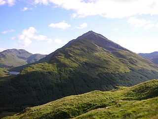
The Cobbler is an 884 metres (2,900 ft) mountain located near the head of Loch Long in Argyll and Bute, Scotland. It is a Corbett, and is an important site for rock climbing in the Southern Highlands. Many maps include the name Ben Arthur, but the name The Cobbler is more widely used. In the 19th century it was referred to as The Cobbler and his Wife.

The Arrochar Alps are a group of mountains located around the heads of Loch Long, Loch Fyne, and Loch Goil. They are part of the Grampian mountains range, which stretch across Scotland. The villages of Arrochar and Lochgoilhead are the nearest settlements. Many of the mountains are located on the Cowal Peninsula in Argyll and Bute, west of Scotland.

Beinn Ìme is the highest mountain in the Arrochar Alps of Argyll, in the Southern Highlands of Scotland. It reaches 1,011 metres (3,317 ft), making it a Munro.
Beinn an Lochain is a mountain in the Arrochar Alps on the Cowal Peninsula, in western Scotland and is a Corbett at 901.7 metres (2,958 ft). Beinn an Lochain is situated within the Argyll Forest Park which is itself within the Loch Lomond and the Trossachs National Park.

Glen Croe is a glen in the heart of the Arrochar Alps on the Cowal Peninsula, in Argyll and Bute, west of Scotland. The glen is surrounded by large and rugged mountains characterised by huge boulders. The Croe Water flows through the glen and into Loch Long.

Binnein an Fhidhleir, is one of the Arrochar Alps, a mountain in Argyll and Bute, western Scotland. Located in the Loch Lomond and The Trossachs National Park.

Strachur and Strathlachlan are united parishes located on the Cowal Peninsula, in Argyll and Bute, west of Scotland. Strachur is a small village on the eastern coast of Loch Fyne.

Beinn Mhòr is the highest mountain on the Cowal Peninsula, west of Loch Eck in Argyll and Bute, west of Scotland. It has a high topographic prominence to height ratio and consequently commands a good all round view.

Beinn Bhuidhe is a mountain near the head of Loch Fyne in Argyll in the Scottish Highlands. It is a Munro with a height of 948 metres (3,110 ft).

Stob an Eas is a 2401 ft (732m) Graham in the Arrochar Alps, Argyll and Bute, Scotland.

Beinn Chorranach is one of the Arrochar Alps, a mountain range that marks the start of the Argyll Highlands and provides a wilderness of long coastlines and high mountains with forested hill sides. Beinn Chorranach's parent peak is Beinn Ìme, the biggest mountain in the range. Beinn Chorranach lies at the head of lower Glen Kinglas and is located between Loch Fyne and Loch Lomond. East of Beinn Chorranach is Loch Lomond as the mountain can be seen from Inversnaid and further east to The Trossachs wilderness. Further west is the rest of the wild Argyll scenery and marks the first real sense of isolation and wilderness after arriving in the Highlands at Loch Lomond.

Beinn Lochain is one of the Arrochar Alps at 703 metres (2,306 ft), in the Argyll Highlands. The mountain is situated to the west of Lochgoilhead. It continues the rugged and wild feel of the local area as it sits next to its higher neighbour Beinn Bheula which reaches a height of over 2,500 feet.

Beinn Reithe is a mountain in Argyll in the Scottish Highlands and forms part of the Ardgoil Peninsula and Arrochar Alps. Beinn Reithe is located between Loch Goil and Loch Long; it reaches a height just over 2000 ft. The mountain is most noticeable from the western shores of Loch Goil and it is also within Loch Lomond and the Trossachs National Park.

Hell's Glen is a glen on the Cowal Peninsula, in Argyll and Bute, west of Scotland, within the Arrochar Alps. The B839 single track road passes through the glen. To the west, the glen leads to Loch Fyne and to the east Lochgoilhead. Glen Mhor (B828) joins the glen about half way along and leeds to Glen Croe at the Rest & be Thankful viewpoint.

Loch Restil is a freshwater loch that lies in the pass between Glen Croe and Glen Kinglas on the Cowal Peninsula, in Argyll and Bute, West of Scotland. One of the main roads to the west of Scotland coast, the A83, passes Loch Restil. The burn that flows from Loch Restil is one of the feeds of Kinglas Water, in Glen Kinglas, which flows under the Butter Bridge.


