
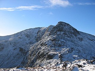
The Cobbler is an 884 metres (2,900 ft) mountain located near the head of Loch Long in Argyll and Bute, Scotland. It is a Corbett, and is an important site for rock climbing in the Southern Highlands. Many maps include the name Ben Arthur, but the name The Cobbler is more widely used. In the 19th century it was referred to as The Cobbler and his Wife.

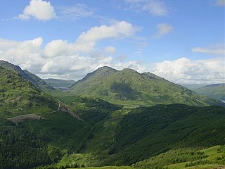
The Arrochar Alps are a group of mountains located around the heads of Loch Long, Loch Fyne, and Loch Goil. They are part of the Grampian mountains range, which stretch across Scotland. The villages of Arrochar and Lochgoilhead are the nearest settlements. Many of the mountains are located on the Cowal Peninsula in Argyll and Bute, west of Scotland.
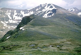
Carn Eighe is a mountain in the Northwest Highlands of Scotland. Rising to 1,183 metres (3,881 ft) above sea level, it is the highest mountain in Scotland north of the Great Glen, the twelfth-highest in the British Isles, and, in terms of relative height, it is the second-tallest mountain in the British Isles after Ben Nevis. Carn Eighe lies between Glen Affric and Loch Mullardoch, and is at the heart of a massif along with its twin peak, the 1,181-metre (3,875 ft) Mam Sodhail.
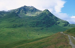
Ben Lui is a mountain in the southern Highlands of Scotland. It is a Munro with a height of 1,130 metres (3,710 ft). Ben Lui is in northeast Argyll and is the highest peak of a mountain chain that includes three other Munros. It has five well-defined ridges radiating out from the summit. Four corries lie between the ridges, including Coirre Gaothaich on the northeast side of the mountain.

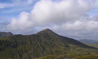
Bidean nam Bian is the highest peak in a group of mountains south of Glen Coe and north of Glen Etive in the Scottish Highlands. With a height of 1,150 metres (3,770 ft), it is a Munro and the highest point in Argyll. It is a complex mountain with many ridges and subsidiary peaks, one of which, Stob Coire Sgreamhach, is classified as a separate Munro.

Beinn Ìme is the highest mountain in the Arrochar Alps of Argyll, in the Southern Highlands of Scotland. It reaches 1,011 metres (3,317 ft), making it a Munro.
Ben Vorlich is a mountain in the Southern Highlands of Scotland. It lies south of Loch Earn and Ardvorlich, and a short distance north of the neighbouring mountain Stùc a' Chroin. Ben Vorlich reaches a height of 985 metres (3,232 ft), making it a Munro.
Beinn an Lochain is a mountain in the Arrochar Alps in western Scotland. A Corbett, reaching 901.7 metres (2,958 ft), Beinn an Lochain is situated within the Argyll Forest Park, which is itself within the Loch Lomond and the Trossachs National Park.
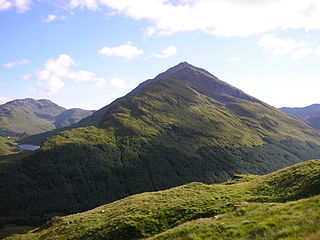
Ben Vorlich is a mountain in the Arrochar Alps of Argyll, in the Southern Highlands of Scotland. It reaches 943 metres (3,094 ft), making it a Munro. It lies between Loch Lomond and Loch Sloy. Ben Vorlich is the highest point of the historic county of Dunbartonshire.

Beinn Narnain is a mountain in the southern Highlands of Scotland, near Arrochar. It forms part of a group of hills known (unofficially) as the Arrochar Alps, and is a Munro. The name Beinn Narnain means "hill of notches", and describes the mountain's notched profile.
Stùc a' Chroin is a mountain in the Breadalbane region of the southern Scottish Highlands. It is a Munro, with a height of 975 metres (3,199 ft). It lies a short distance south of Ben Vorlich and east of Strathyre. The boundary between the council areas of Perth and Kinross and Stirling passes through the summit of the peak, and the town of Callander lies to the south.

Beinn Dubhchraig is a mountain in the Scottish Highlands, west of Crianlarich in the northern part of Loch Lomond and the Trossachs National Park. It is a Munro with a height of 978 metres (3,209 ft). It is overshadowed by its neighbour Ben Lui, although it is well seen from the main A82 road. Its name means "mountain of the black rock", referring to the steep and rocky face on the southwest slopes above Loch Oss, which offer scrambling routes to the summit.

Gairich, sometimes Sgurr Gairoch, is a mountain in Lochaber in the Northwest Highlands of Scotland. It is on the southern side of Loch Quoich, with Glen Garry to the east and Glen Kingie to the south, 25 kilometres north-northwest of Fort William.

Ben Chonzie or Ben-y-Hone is a mountain in the Breadalbane region of the Scottish Highlands. It is eleven kilometres northwest of Crieff. It stands at 931 metres (3,054 ft) and is therefore listed as a Munro. It is the highest point of a large area of moorland and rounded hills between Loch Earn and Loch Tay, and with a broad, flat summit and relatively few distinguishing features, it is often regarded as one of Scotland's least interesting Munros.

Ben Tee is a Scottish mountain situated in the Lochaber area of the Highland council area, some 15 kilometres north of Spean Bridge. It is rated as one of the best of Scotland's smaller mountains with Hamish Brown saying:
Ben Tee is such a shapely cone that it is instantly recognisable from anywhere around the Great Glen or along the Garry. Its isolated situation makes it one of Scotland’s finest summit viewpoints.

Beinn Bhuidhe is a mountain near the head of Loch Fyne in Argyll in the Scottish Highlands. It is a Munro with a height of 948 metres (3,110 ft).
Sgairneach Mhòr is a Scottish mountain which lies in a group of seven Munros near the summit of the Pass of Drumochter and are known as the Drumochter mountains or informerly as the “A9 Munros”. The mountain is situated 13 km SSW of Dalwhinnie and four km east of the large Loch Ericht.

The Loch Sloy Hydro-Electric Scheme is a hydro-electric facility situated between Loch Sloy and Inveruglas on the west bank of Loch Lomond in Scotland. It is also within the Arrochar Alps.

Beinn Mhanach, also anglicized Ben Vannoch, is a mountain in the Breadalbane region of the Scottish Highlands. It is east from Bridge of Orchy, overlooking Loch Lyon to the south and Gleann Cailliche to the north. It is a Munro with a height of 953 metres (3,127 ft). The mountain has two rounded summits; the western one is called Beinn a 'Chuirn and rises to 923 metres (3,028 ft). From the West Highland Line and the A82 road, the mountain can be seen clearly 8 km north-east up the Auch Gleann. On the southern side the slopes are grassy but the more remote northern side is craggier.

Glen Kinglas is a glen located on the Cowal Peninsula, in Argyll and Bute, west of Scotland. The glen is one of the main glens in the Arrochar Alps, the A83 road from Arrochar and Loch Lomond passes through the glen. At the north end of the glen, a pass leads to Glen Croe, passing Loch Restil. At the south of the glen the A815 road leaves the A83 and leads through the Cowal Peninsula to Dunoon on the Firth of Clyde coast. The A83 continues on past Cairndow and Loch Fyne Oysters to Inveraray and Inveraray Castle on Loch Fyne.


