
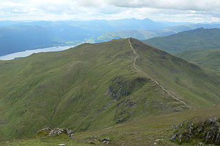
The Arrochar Alps are a group of mountains located around the head of Loch Long, Loch Fyne, and Loch Goil, near the villages of Arrochar and Lochgoilhead, on the Cowal Peninsula in Argyll and Bute, Scotland. The mountains are especially popular with hillwalkers, due to their proximity and accessibility from Glasgow. They are largely within the Loch Lomond and The Trossachs National Park and in part also extend into the Argyll Forest Park. Glens which go into the heart of the range include: Glen Croe, Hell's Glen and Glen Kinglass.

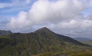
Beinn Ìme is the highest mountain in the Arrochar Alps, in the Southern Highlands of Scotland. There are three usual routes of ascent. From Succoth, one may follow the same path that is used to reach The Cobbler before taking the right fork near the base of the Cobbler's main crags and continuing up the glen, across the bealach and up Ben Ìme's eastern ridge. Alternatively, the summit can be reached from the pass of Rest and be Thankful and from the Loch Lomond side, using the private road that leads to Loch Sloy. Beinn Ìme separates the Dunbartonshire landscape of Loch Lomond in the East and the Argyll Highlands of Loch Fyne and Loch Goil anywhere north, west, south west. Beinn Ìme is the landmark to the entrance to Argyll.
Ben Vorlich is a mountain located in the southern part of the Highlands of Scotland. Due to its prominence when seen from the lower ground of the Central Belt, Ben Vorlich is one of the most commonly seen of Munros, Scotland's peaks of 3000ft height or above. It lies in an area of land bounded to the north by Loch Earn, and to the west by Loch Lubnaig. The town of Callander lies to the south.

Ben Vorlich is a Scottish mountain situated between the northernmost section of Loch Lomond and Loch Sloy. It is one of the Arrochar Alps, though it lies separate from the other peaks in the range, as indicated by the large topographic prominence. It is the highest point of the historic county of Dunbartonshire.

Beinn Narnain is a mountain in the southern Highlands of Scotland, near Arrochar. It forms part of a group of hills known (unofficially) as the Arrochar Alps, and is a Munro. The name Beinn Narnain means "hill of notches", and describes the mountain's notched profile.
Beinn Ghlas is a mountain in the Southern Highlands of Scotland. It lies on the north shore of Loch Tay and is part of the Ben Lawers Range. It lies on the popular path to Ben Lawers from the National Trust for Scotland car park, with the result that many walkers traverse the summit of Beinn Ghlas without realising it. The popularity of the path meant that it suffered from severe erosion, but it has been reconstructed in recent years.

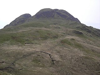
The Brack is a mountain, located in the Arrochar Alps, on the south side of Glen Croe, near Loch Goil in Argyll and Bute in Scotland. The Brack has two summits: the lower peak, Cruach Fhiarach, can be seen from the shores of Loch Long, and the main peak is seen from Glen Croe and Loch Goil.

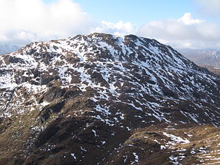
Ben Vane is a Scottish mountain situated in the southern Highlands. The underlying geology almost entirely comprises the Beinn Bheula Schist Formation - psammite and pelite with a Siluro-Devonian dyke prominent round the northern and eastern face. It is one of the Arrochar Alps and stands slightly separate from the other mountains of the group being connected on its western side to the neighbouring Beinn Ìme by a low col at 492 metres. Ben Vane itself just qualifies as a Munro reaching a height of 915 metres (3,002 feet) and is characterised by steep and rugged slopes which fall away to the Inveruglas Water to the east and the Allt Coiregroigan to the south; to the north the descent is more undulating going over the subsidiary top of Beinn Dubh before falling to the valley at the north end of Loch Sloy. Dense forestry cloak the mountain on its lower southern slope in Allt Coiregroigan. Also on these southern slopes by the Allt Coiregroigan is a disused quarry which provided crushed stone used for the construction of the Loch Sloy dam in the late 1940s. The dam wall lies two km to the north of the quarry and a conveyor belt was constructed to carry the crushed stone over the lower slopes of Ben Vane to the batching plant beside the dam.

Beinn a' Chreachain is a Scottish mountain, with a conical top, to the north-west of Loch Lyon.

Beinn Heasgarnich is a Scottish mountain. It lies approximately 2 km to the south of Loch Lyon.

Ben Bhuidhe is a Scottish mountain at the head of Loch Fyne, Argyll and Bute.
Beinn Tulaichean is a Scottish mountain. It is not much more than the southern top of Cruach Ardrain, with a descent of only 120m before the ascent to its larger neighbour. It is located approximately 10 km to the north of Loch Katrine close to the site of Robert Roy MacGregor's house.
Beinn Chabhair is a Scottish mountain. It has fine views down to Loch Lomond.

Beinn Luibhean is one of the Arrochar Alps in the Argyll Highlands of Scotland, located to the northern side of Glen Croe between Loch Long in Dunbartonshire to the East and Loch Fyne in the Remote Highlands of Argyll to the West. The landscape to the West of Loch Long changes as the shoreline provides the gateway to Argyll, the district in the Western Highlands of Scotland that form the first ingredients to a wilderness and has a real sense of remoteness and isolation from the Lowlands and Populated parts of the Central Belt. The Arrochar Alps are a Mountain Range which Run from the Loch Goil in the South and West towards Tyndrum in the North. Beinn Luibhean stands at a height of 2821 ft, 860 m. The Nearest Mountains to Beinn Luibhean include The Cobbler, Beinn Ime and Beinn Narnain.

Stob an Eas is a 2401 ft (732m) Graham in the Arrochar Alps, Argyll and Bute, Scotland.

Stob na Boine Druim-fhinn is a mountain in the Arrochar Alps in the Argyll Highlands. The mountain itself is part of the group of mountains within the Arrochar Alps to the west of Loch Goil. The mountain can be seen from Lochgoilhead.
Cruach nam Mult is a mountain in the Arrochar Alps, Argyll, Scotland which lies to the southern side of Hell's Glen. The mountain is near Loch Fyne and GlenGoil and is part of the northern side of the area of the Arrochar Alps that follow south to Loch Goil.

Beinn Reithe is a mountain in Argyll in the Scottish Highlands and forms part of the Ardgoil Peninsula and Arrochar Alps. Beinn Reithe is located between Loch Goil and Loch Long; it reaches a height just over 2000 ft. The mountain is most noticeable from the western shores of Loch Goil and it is also within Loch Lomond and the Trossachs National Park.
Argyll's Bowling Green is an area on the Ardgoil estate in Argyll and Bute, Scotland. It is also known as the Ardgoil peninsula and is the most southerly part of the Arrochar Alps and lies between Loch Goil and Loch Long. It is part of the Argyll Forest Park and is within the Loch Lomond and the Trossachs National Park.

Beinn na h-Uamha is a mountain in the Northwest Highlands of Scotland. It lies in the Ardgour area of Lochaber, west of the village of Corran.

