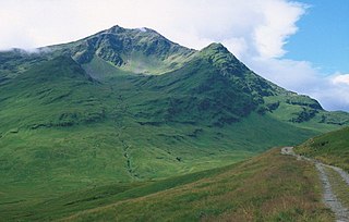
Ben Lui is a mountain in the southern Highlands of Scotland. It is a Munro with a height of 1,130 metres (3,710 ft). Ben Lui is in northeast Argyll and is the highest peak of a mountain chain that includes three other Munros. It has five well-defined ridges radiating out from the summit. Four corries lie between the ridges, including Coirre Gaothaich on the northeast side of the mountain.

Bidean nam Bian is the highest peak in a group of mountains south of Glen Coe and north of Glen Etive in the Scottish Highlands. With a height of 1,150 metres (3,770 ft), it is a Munro and the highest point in Argyll. It is a complex mountain with many ridges and subsidiary peaks, one of which, Stob Coire Sgreamhach, is classified as a separate Munro.

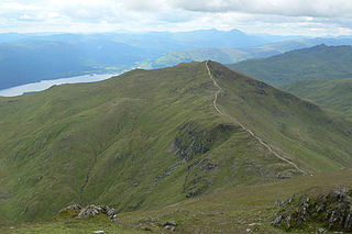
Stob Coire Sgreamhach is a mountain in Lorn, south of Glen Coe in the Scottish Highlands. Its height is 1,072 metres (3,517 ft). It is part of the Bidean nam Bian massif and is often considered a subsidiary peak of Bidean, though since the 1997 revision of Munros Tables it has been classified as a separate Munro. To the northeast is the ridge of Beinn Fhada.

Beinn Ìme is the highest mountain in the Arrochar Alps of Argyll, in the Southern Highlands of Scotland. It reaches 1,011 metres (3,317 ft), making it a Munro.
Beinn an Lochain is a mountain in the Arrochar Alps in western Scotland. A Corbett, reaching 901.7 metres (2,958 ft), Beinn an Lochain is situated within the Argyll Forest Park, which is itself within the Loch Lomond and the Trossachs National Park.
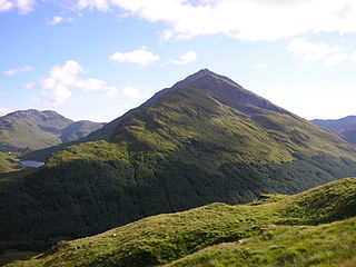
Ben Vorlich is a mountain in the Arrochar Alps of Argyll, in the Southern Highlands of Scotland. It reaches 943 metres (3,094 ft), making it a Munro. It lies between Loch Lomond and Loch Sloy. Ben Vorlich is the highest point of the historic county of Dunbartonshire.

Beinn Narnain is a mountain in the southern Highlands of Scotland, near Arrochar. It forms part of a group of hills known (unofficially) as the Arrochar Alps, and is a Munro. The name Beinn Narnain means "hill of notches", and describes the mountain's notched profile.
Beinn Ghlas is a mountain in the Breadalbane region of the Scottish Highlands. It lies on the north shore of Loch Tay and is part of the Ben Lawers Range. It is a Munro with a height of 1,103 metres (3,619 ft).

Beinn Dorain, is a mountain in the Breadalbane region of the Scottish Highlands. It overlooks Bridge of Orchy in Argyll. It is a Munro with a height of 1,076 metres (3,530 ft). The mountain is the subject of Duncan Ban MacIntyre's best known Gaelic poem, Moladh Beinn Dòbhrainn ; MacIntyre had spent his youth and had worked as a gamekeeper in these parts.

Beinn Dubhchraig is a mountain in the Scottish Highlands, west of Crianlarich in the northern part of Loch Lomond and the Trossachs National Park. It is a Munro with a height of 978 metres (3,209 ft). It is overshadowed by its neighbour Ben Lui, although it is well seen from the main A82 road. Its name means "mountain of the black rock", referring to the steep and rocky face on the southwest slopes above Loch Oss, which offer scrambling routes to the summit.

An Caisteal is a mountain in the Breadalbane region of the Scottish Highlands, south of the village of Crianlarich. It is a Munro with a height of 995 metres (3,264 ft).

Beinn Achaladair is a Scottish mountain situated six kilometres north east of the hamlet of Bridge of Orchy. The mountain stands on the border of the Perth and Kinross and Argyll and Bute council areas.

Beinn a' Chroin is a mountain in the Breadalbane region of the Scottish Highlands, six kilometres south of Crianlarich. With a height of 941 metres (3,087 ft) it qualifies as a Munro.

Beinn Challuim is a mountain in the Breadalbane region of the Scottish Highlands. It is east of the village of Tyndrum, in the Forest of Mamlorn, an ancient deer forest at the northern edge of Loch Lomond and the Trossachs National Park. It is a Munro with a height of 1,025 metres (3,363 ft).

Beinn Sgulaird or Beinn Sguiliaird is a mountain in the Lorn region of the Scottish Highlands, between Glen Creran and Glen Etive. It has a height of 937 m (3074 ft) and is classed as a Munro. The mountain takes the form of a long ridge which runs from southwest to northeast, three kilometres of which lie above 800 m. Hillwalkers commonly traverse the ridge from north to south, as this gives the best views of the Hebrides to the west, in particular the Isle of Mull. While most walkers start from Glen Creran to the west, an ascent from Glen Etive is also possible.

Beinn a' Chreachain is a Scottish mountain, with a conical top, to the north-west of Loch Lyon.

Beinn Heasgarnich is a mountain in the Breadalbane region of the Scottish Highlands. It lies about 2 km south of Loch Lyon. It is a Munro with a height of 1,078 metres (3,537 ft).

Beinn Bhuidhe is a mountain near the head of Loch Fyne in Argyll in the Scottish Highlands. It is a Munro with a height of 948 metres (3,110 ft).
Beinn Tulaichean is a Scottish mountain. It is not much more than the southern top of Cruach Ardrain, with a descent of only 120m before the ascent to its larger neighbour. It is located approximately 10 km to the north of Loch Katrine close to the site of Robert Roy MacGregor's house.

Beinn Mhanach, also anglicized Ben Vannoch, is a mountain in the Breadalbane region of the Scottish Highlands. It is east from Bridge of Orchy, overlooking Loch Lyon to the south and Gleann Cailliche to the north. It is a Munro with a height of 953 metres (3,127 ft). The mountain has two rounded summits; the western one is called Beinn a 'Chuirn and rises to 923 metres (3,028 ft). From the West Highland Line and the A82 road, the mountain can be seen clearly 8 km north-east up the Auch Gleann. On the southern side the slopes are grassy but the more remote northern side is craggier.


