Loch Maree contains five large wooded islands and over 60 smaller ones,[8][9] many of which have their own lochans. The largest island, Eilean Sùbhainn, contains a loch that itself contains an island,[10] a situation that occurs nowhere else in Great Britain.[11]Isle Maree holds the remains of a Pre-Reformation chapel and Christian pilgrimage shrine believed to be the 8th century hermitage of Saint Máel Ruba (d. 722), a Celtic Church missionary from Bangor Abbey in Gaelic Ireland who also founded the monastery of Applecross in 672.[12] It is after him that Loch Maree is named; prior to the saint's arrival in the area the loch is believed to have been named Loch Ewe, as evidenced by the name of the village of Kinlochewe (Scottish Gaelic: Ceann Loch Iù, meaning "Head of Loch Ewe") which is located at the eastern end of Loch Ewe.[13]
The loch is important for wildlife. It is the site of one of the largest breeding concentrations of black-throated diver in Great Britain, and also holds an important population of otter. The islands of Loch Maree are the location of some of the best native Caledonian pinewood in Scotland, and are particularly noted for their dragonflies, with 12 species having been recorded.[14] The waters, islands and shoreline of Loch Maree are protected by several overlapping conservation designations.
Geography
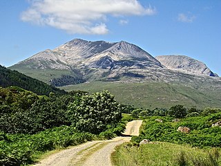
Slioch seen from the shores of Loch Maree.Loch Maree by Sir David Young Cameron, c.1900–1924
Loch Maree is much longer than it is wide, stretching along a northwest-southeast axis. The outflow is via the short River Ewe, through which water enters the sea loch of Loch Ewe, close to the village of Poolewe; the village of Kinlochewe lies at the head of the loch at the southeastern end. The A832 road between the two runs along much of the southwestern shore of the loch, but diverges from it in the north to run via Gairloch, along the coast from Poolewe.[10]
Loch Maree is divided into three main basins, and has many islands: the ratio of the area of the islands to the area of the surface water is greater than any other large loch in Scotland.[15] The deepest of the basins, at 112m (367ft), is known as the Grudie Basin, and lies between Isle Maree and the head of the loch. To the northwest of this basin lies the Slattadale Basin, which contains the majority of the islands. North of the islands lies a shallower area, separating the Slattadale Basin from the Ardlair Basin, the most irregularly shaped of the three.[13]
The most prominent mountain on the northern side of Loch Maree is Slioch, one of Scotland's Munros (a mountain over 3,000ft (910m) high), which dominates the eastern end of the loch above Kinlochewe. It is composed mainly of Torridonian sandstone of Precambrian age, lying on a bedrock of Lewisian gneiss. It is popular for hill walking, scrambling and climbing.[16] Other peaks on the northern side include Beinn Àirigh Charr and Beinn Làir, both of which are classified as Corbetts.[17] The entire length of the northeastern shore of Loch Maree forms part of the 35,072ha (86,664 acres) Letterewe, Heights of Kinlochewe & Tournaig Estate, which extends north over an area known as the Fisherfield Forest.[18] The southwestern side of Loch Maree is also mountainous, comprising the Torridon Forest. The most prominent peak is Beinn Eighe, which is capped with white quartzite.[19] Three main landowners occupy the southwestern shore: from south to north these are NatureScot (the Beinn Eighe National Nature Reserve), the 5,154ha (12,737 acres) Grudie & Talladale Estate,[20] and the 21,701ha (53,625 acres) Gairloch (Flowerdale & Shieldaig) & Conon Estate.[21]
History
Victoria Falls, named following a visit by Queen Victoria.
Between 671 and 722, Celtic Church missionary St Máel Ruba arrived at Loch Maree, and founded a chapel and Christian pilgrimage shrine on Eilean Maolruibhe. Remains of this chapel were reportedly still visible in 1861 but no traces now remain, although the burial ground associated with the chapel is still extant. A small covered holy well on the island is said to have been consecrated by the saint.[12]
During the middle ages the island of Eilean Ghrùididh on Loch Maree was a centre for the MacBeaths; in or shortly after 1430 the MacBeaths were displaced by Clan MacLeod. Investigation of the island in 1965 found a fortified area measuring 44 by 36 metres with walls 1m thick and 2m high, with a 1.8m deep dungeon in the southeast corner. No buildings were found within the fortifications.[22]
Due to its remote location there is now little industry surrounding Loch Maree, however the area was formerly a centre for ironworking. During the seventeenth century up to 8hectares of oak woodlands a day were turned into charcoal to fuel the smelting of bog iron at Letterewe on the northeast shore.[13] Workmen from these iron furnaces are said to have been buried on Isle Maree.[12] Remains of one iron furnace can be seen at a site known as the Red Smiddy on the northeast bank of the River Ewe between the outflow from the loch and Poolewe. Pieces of ore, slag and iron have been found at this site.[23]
The loch became a popular spot for troutfishing after Queen Victoria visited the Loch Maree Hotel at Talladale in 1877,[24] a visit which led to the naming of Victoria Falls, an attractive waterfall in the vicinity of the hotel.[25] In 1893, there was a proposal to build a branch railway from Achnasheen to Aultbea along the south shore of Loch Maree. The railway would have increased Victorian tourist traffic, as well as providing a service for fisheries and the mail and a connection to Stornoway, however the plan was later abandoned.[26]
Ecology
Loch Maree is of international importance for its special wildlife and biodiversity, and is the site of one of the largest breeding concentrations of black-throated diver in Great Britain.[14]
Sea trout and salmon are an important part of the loch's ecosystem, providing food for black-throated diver and otter (Lutra lutra): juvenile trout can be an important part of the diet of black-throated diver.[27] Until recently, thousands of adult sea trout (seagoing brown troutSalmo trutta) and salmon (Salmo salar) returned to the loch from the sea every summer. Sea trout gathered in huge numbers in certain bays, providing some of the most exciting angling in Scotland for which the loch had an international reputation. A British record sea trout of 19.5lb (8.8kg) was caught on a "dapping fly" in the loch in 1952.[28] The sea trout fishery collapsed in the 1980s and 1990s.[29] The loch also has two separate populations of Arctic charr (Salvelinus alpinus) about which little is known. One form of charr, with a big eye which feeds on the bottom in deep water matures at less than 15cm. The other form grows to over 32cm and can sometimes be seen in shoals ruffling the surface when the loch is calm.[30]
The islands of Loch Maree are wooded, being the location of some of the best native Caledonian pinewood in Scotland. These woodlands, along with others in Wester Ross, are genetically distinct from other pinewoods in Scotland, showing more similarity to those in southern Europe.[14] It is thought that this results from the fact that western Scotland became ice-free first at the end of the last ice-age, allowing pine to move north along the western fringe of Europe. Pines reached Eastern Scotland from more northerly areas during a later period, as the ice sheets retreated further.[31]Scots pine are the dominant species in these woodlands, however other tree species such as rock whitebeam and juniper are also present. The islands of Loch Maree are particularly noted for their dragonflies, with 12 species having been recorded, including the northern emerald, azure hawker and white-faced darter.[14]Pine martens and white-tailed sea eagles can be found on the islands,[32] which are also a breeding site for redwings; greylag geese were known to breed here in the past, but have not done so since the 1970s.[33]
Over 60 islands within the loch are designated as the Loch Maree Islands National Nature Reserve (NNR),[35] which has since 2014 been jointly managed with the neighbouring Beinn Eighe NNR as a single reserve.[38] The Beinn Eighe and Loch Maree Islands NNR forms part of the designated Core Zone of the Wester RossUNESCOBiosphere reserve.[39]
Button-box accordionist, Fergie MacDonald topped the Scottish pop charts in 1966 with the tune "Loch Maree Islands"[42] which pays tribute to the views of the loch, and vocal versions have been recorded by many artists over the years, notably Calum Kennedy. More recently a version of the song was included on Peat and Diesel's 2019 album Uptown Fank.[43]
In the 2009-10 series of the BBC's Natural World, episode 6, Highland Haven, stayed closer to home than usual, with a year-long look at the environment and wildlife of Loch Maree and its surroundings.[44][45]
Loch Maree and its islands, including Isle Maree, Juniper and Rough Islands are the setting of Oscar de Muriel's 2018 historical-crime novel Loch of the Dead, the fourth book in his Frey & McGray series.[46]
Thomas Pennant, writing in 1772, recorded that the loch was considered a holy well whose waters were thought to have curative effects, with being submerged in the water thought to be a cure for lunacy.[13]
Isle Maree holds an oakwish tree made famous by a visit in 1877 by Queen Victoria mentioned in her published diaries. The tree, and others surrounding it, are festooned with hammered-in coins. It is near the traditional Christian pilgrimage shrine and holy well of local Celtic Church missionary St. Máel Rubha, whose intercession was believed to cure mental illnesses and to whom votive offerings were made, including the sacrifice of bulls, which continued up to the 18th century, according to records,[48] leading to speculation that the island was a place of pre-Christian pagan worship which was taken over by the saint.[12] The same island contains ancient stands of oak and holly which have been linked with ancient Scottish druids.[49]
SS Mabel, a small passenger steamer operating on the loch between 1883 and 1911.
Related Research Articles
The national nature reserves (NNRs) of Scotland are areas of land or water designated under the Wildlife and Countryside Act 1981 as containing habitats and species of national importance. National nature reserves can be owned by public, private, community or voluntary organisations but must be managed to conserve their important habitats and species, as well as providing opportunities for the public to enjoy and engage with nature. There are currently 43 NNRs in Scotland, which cover 154,250 hectares (1,542.5 km2), or less than 1.5% of the land area of Scotland. They range in size from Corrieshalloch Gorge at 7 ha to Mar Lodge Estate, which covers 29,324 ha.
Loch Leven is a fresh water loch located immediately to the east of the burgh of Kinross in Perth and Kinross council area, central Scotland. Roughly triangular, the loch is about 6 km (3.7 mi) at its longest. Prior to the canalisation of the River Leven, and the partial draining of the loch in 1826–36, Loch Leven was considerably larger. The drop in water level by 1.4 m reduced the loch to 75% of its former size, and exposed several small islands, as well as greatly increasing the size of the existing ones.
Beinn Eighe is a mountain massif in the Torridon area of Wester Ross in the Northwest Highlands of Scotland. Lying south of Loch Maree, it forms a long ridge with many spurs and summits, two of which are classified as Munros: Ruadh-stac Mòr at 1,010 m (3,314 ft) and Spidean Coire nan Clach at 993 m (3,258 ft). Unlike most other hills in the area it has a cap of Cambrian basal quartzite which gives the peaks of Beinn Eighe a distinctive light colour. Its complex topography has made it popular with both hillwalkers and climbers and the national nature reserve on its northern side makes it an accessible mountain for all visitors.
Ben Lawers is the highest mountain in the Breadalbane region of the Scottish Highlands. It lies north of Loch Tay and is the highest peak of the 'Ben Lawers group', a ridge that includes six other Munros: Beinn Ghlas, Meall Garbh, Meall Corranaich, An Stùc, Meall Greigh and Meall a' Choire Leith. It is also the highest peak in Perthshire, and the tenth highest Munro in Scotland. Ben Lawers was long thought to be over 4,000 feet in height, but accurate measurement in the 1870s showed it to be only 3,983 feet (1,214 m). It is formed of metamorphic rock, most notably calcareous mica-schists, and lower down, schistose grits.
Loch Shiel is a freshwater loch situated 20 kilometres (12 mi) west of Fort William in the Highland council area of Scotland. At 28 kilometres long it is the 4th longest loch in Scotland, and is the longest to have retained a natural outflow without any regulation of its water level, being 120 m (393 ft) deep. Its nature changes considerably along its length, being deep and enclosed by mountains in the north east and shallow surrounded by bog and rough pasture in the south west, from which end the 4 km River Shiel drains to the sea in Loch Moidart near Castle Tioram.
Wester Ross is an area of the Northwest Highlands of Scotland in the council area of Highland. The area is loosely defined, and has never been used as a formal administrative region in its own right, but is generally regarded as lying to the west of the main watershed of Ross, thus forming the western half of the county of Ross and Cromarty. The southwesternmost part of Ross and Cromarty, Lochalsh, is not considered part of Wester Ross by the local tourist organisation, Visit Wester Ross, but is included within the definition used for the Wester Ross Biosphere Reserve.
Kinlochewe is a village in Wester Ross in the Northwest Highlands of Scotland. It is in the parish of Gairloch, the community of Torridon and Kinlochewe and the Highland council area. It lies near the head of Loch Maree in its magnificent valley, and serves as a junction between the main Ullapool road north, and that which heads west to the coast at Loch Torridon. Loch Maree was at one time also known as Loch Ewe, hence the village's apparently confused name.
The A832 is a road in the Scottish Highlands, linking Cromarty, on the east coast, to Gairloch on the west coast, and beyond Gairloch to Braemore Junction. It is 126 miles (203 km) long and runs entirely in the former county of Ross and Cromarty. The road forms part of the Wester Ross Coastal Trail.
Loch Ewe is a sea loch in the region of Wester Ross in the Northwest Highlands of Scotland. The shores are inhabited by a traditionally Gàidhlig-speaking people living in or sustained by crofting villages, the most notable of which, situated on the north-eastern shore, is the Aultbea settlement.
Eilean Sùbhainn is the largest of several small islands in Loch Maree, Wester Ross, Scotland. It is the second largest freshwater island in Scotland after Inchmurrin.
Loch Veyatie is a large freshwater loch in north-west Scotland. It stretches for 6 km north-westwards from the settlement of Elphin, and lies between Suilven and Cùl Mòr. The loch is located in an area known as the Assynt-Coigach National Scenic Area, one of 40 such areas in Scotland.
Loch na h-Oidhche is a remote freshwater loch lying between Loch Torridon and Loch Maree in the Flowerdale Forest, Wester Ross, Scotland. It is approximately 4.5 mi (7.2 km) north of the small village of Torridon and 8 mi (13 km) southeast of Gairloch.
Loch a' Bhraoin, Loch Broom, is a freshwater loch, located in Wester Ross, in Ross-shire, on the west coast of Scotland.
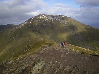
Meall a' Ghiubhais is a mountain in the Northwest Highlands, Scotland. It lies in Wester Ross, close to the village of Kinlochewe.
Lochan Fada is a large remote and deep freshwater loch that is located three miles north-east of Loch Maree in Wester Ross in the Northwest Highlands of Scotland.
Loch Clair is a small remote shallow low-altitude freshwater loch, located within the Coulin Forest, some three miles to the south-west of Kinlochewe in Wester Ross. Loch Clair is the lower of two lochs in the same valley and is aligned on a southeast-northwest bearing. The other loch is Loch Coulin which is fed by the River Coulin, the waters of which in turn flow out of Loch Coulin through a short unnamed river into Loch Clair. A small lochan, Loch Bharranch, is located a mile to the west and drains into the western end of Loch Clair through an unnamed burn.
Loch Coulin is a small remote shallow low-altitude freshwater lochan, located within the Coulin Forest, some four miles to the south-west of Kinlochewe in Wester Ross. It is fed by the river Coulin from the south and its outflow is into Loch Clair in the north-west. Loch Coulin is within Beinn Eighe National Nature Reserve.
Loch Kernsary also known as Loch na h-Airde Bige is a small remote shallow low-altitude freshwater loch, located directly southeast of Poolewe in Kinlochewe, Wester Ross. It is fed by the river Coulin from the south and its outflow is into Loch Clair in the north-west. The Kernsary River drains into the loch from the south and in turn is drained through a tiny lochan Loch Poll Uidge à Chrò. The Lochan drains into the Inveran River, that drains a short distance into Loch Maree directly to the south-east.
References
1 2 Bathymetrical Survey of the Fresh-Water Lochs of Scotland, 1897-1909. Volume I, Table 1.
1 2 Bathymetrical Survey of the Fresh-Water Lochs of Scotland, 1897-1909. Volume I, Table 2.
↑ Bathymetrical Survey of the Fresh-Water Lochs of Scotland, 1897-1909. Volume I, Table 4.
↑ Bathymetrical Survey of the Fresh-Water Lochs of Scotland, 1897-1909. Volume I, Table 3.
↑ Bathymetrical Survey of the Fresh-Water Lochs of Scotland, 1897-1909. Volume I, Table 5.
This page is based on this Wikipedia article Text is available under the CC BY-SA 4.0 license; additional terms may apply. Images, videos and audio are available under their respective licenses.