Glenmore Forest Park

Last updated

Glenmore National Nature Reserve
IUCN category IV (habitat/species management area) [1]
Glenmore Forest - geograph.org.uk - 319334.jpg
Glenmore Forest
Highland UK relief location map.jpg
Red pog.svg
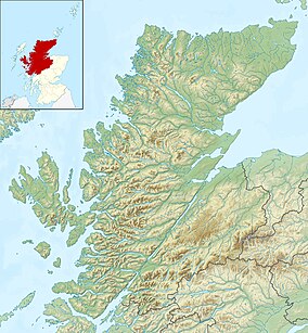
A map showing the location of the Glenmore Forest Park within Highland.
Location Highland, Scotland
Coordinates 57°10′12″N3°42′58″W / 57.170°N 3.716°W / 57.170; -3.716
Area21.1 km2 (8.1 sq mi) [2]
Designation NatureScot
Established2007 [3]
Owner Forestry and Land Scotland
Website Glenmore Forest Park

Glenmore Forest Park is a remnant of the Caledonian Forest near Aviemore in the Badenoch and Strathspey district of Highland, Scotland. Owned and managed by Forestry and Land Scotland, it lies within the Cairngorms National Park, and is one of six forest parks in the country. [4] The forest park, which was established in 1948, [5] covers 35.7 km2, [6] of which 21.1 km2 is designated as a national nature reserve (NNR). [2] Glenmore surrounds Loch Morlich, and is below the rise of the Cairngorms to the south; to the north the park extends to the summit of Meall a' Bhuachaille. The forest forms part of an expanse of Caledonian Forest that stretches from Glen Feshie to Abernethy, and which as a whole forms the largest single area of this habitat remaining in Scotland. [7] It is home to much wildlife including Scottish crossbills, crested tits, capercaillie, narrow-headed ants, red squirrels and red deer. [8] [9]

Contents

The Sportscotland National Centre Glenmore Lodge is situated about 1.5 km east of Loch Morlich, and is surrounded by the park. [10] During the Second World War the area was a training base for Norwegian resistance fighters, who are commemorated by a memorial located near to the visitor centre. [11]

Folklore

A fairy known as the Ly Erg, a portent of death, is said to frequent the area of the forest. [12] According to local legends a small lake in the park, An Lochan Uaine , has its water coloured in green due to the fairies, who wash their green clothes in the lake. [13]

Flora and fauna

As a Caledonian Forest, the predominant tree species at Glenmore is Scots pine. Around half of the pines originate as a result of natural processes, whilst the remainder have been planted using seeds of local origin. Broadleaved species such as birch, willow and rowan are also present, and there are areas of juniper scrub and alder. [7] Trees are expanding on to areas of open heath, and a natural tree line is developing at the upper edge of the forest. The forest floor is home to many species associated with native pinewoods including one-flowered wintergreen, twinflower, small cranberry and intermediate wintergreen. [14]

Glenmore Forest is important for many bird species, especially Scottish crossbill and capercaillie. In 2006 Glenmore was identified as having the highest productivity of capercaillie for any monitored site in Scotland. Golden eagles can be seen over parts of the forest, and ospreys regularly hunt over Loch Morlich. Peregrine falcons and merlins also hunt in the area, and occasionally breed at Glenmore. Dotterel can occasionally be found on the higher parts of the area, above the tree line, although they normally prefer the open habitats of the mountain plateau. The rivers and lochs of the forest provide a home for otters, and are an important spawning area for Atlantic salmon. [14]

Conservation

A Scots pine in the park Glenmore scots pine.png
A Scots pine in the park

Extraction of timber from Glenmore dates back to at least the 17th century, with large scale extraction beginning in 1783. Felling continued into the 20th century, and the area was also used to graze sheep, and as a deer forest. During this period little tree regeneration occurred. The Forestry Commission acquired Glenmore in 1923, and began to restock the wood, using Scots pines and non-native species such as Norway spruce and Sitka spruce. The area was declared a forest park 1948, and became a national nature reserve in 2007. Forestry and Land Scotland now plan to remove all non-native tree species, and replant areas with Scots pine of local provenance and other native trees. [5] [3]

In addition to its status as a national nature reserve and a forest park Glenmore is also designated as a Site of Special Scientific Interest (SSSI), [9] and forms part of the Cairngorms Special Protection Area (SPA). There are also two Special Areas of Conservation (SAC) that overlap with the NNR: the Cairngorms SAC and the River Spey SAC. [14] The NNR is classified as a Category IV protected area by the International Union for Conservation of Nature. [1]

See also

Related Research Articles

<span class="mw-page-title-main">Loch Garten</span> Loch in Scottish Highlands, Scotland

Loch Garten is a large Highland freshwater loch near Boat of Garten, in the Strathspey area of the Cairngorms National Park, in Scotland. It is surrounded by the tall pine trees of the Abernethy Forest, a large area of which is an RSPB nature reserve. The loch is renowned for its breeding population of ospreys, which lend Boat of Garten its nickname "The Osprey Village".

<span class="mw-page-title-main">Cairngorms</span> Mountain range in the eastern Highlands of Scotland

The Cairngorms are a mountain range in the eastern Highlands of Scotland closely associated with the mountain Cairn Gorm. The Cairngorms became part of Scotland's second national park on 1 September 2003. Although the Cairngorms give their name to, and are at the heart of, the Cairngorms National Park, they only form one part of the national park, alongside other hill ranges such as the Angus Glens and the Monadhliath, and lower areas like Strathspey.

<span class="mw-page-title-main">Cairngorms National Park</span> National park in Scotland

Cairngorms National Park is a national park in northeast Scotland, established in 2003. It was the second of two national parks established by the Scottish Parliament, after Loch Lomond and The Trossachs National Park, which was set up in 2002. The park covers the Cairngorms range of mountains, and surrounding hills. Already the largest national park in the United Kingdom, in 2010 it was expanded into Perth and Kinross.

<span class="mw-page-title-main">Loch Rannoch</span> Freshwater loch in Perth and Kinross, Scotland

Loch Rannoch is a freshwater loch in Perth and Kinross, Scotland. It is over 15 kilometres (9.3 mi) long in a west–east direction with an average width of about 1.2 kilometres (0.75 mi), and is deepest at its eastern end, reaching a depth of 130 metres (440 ft). The River Tummel begins at its eastern end, where the small village of Kinloch Rannoch can be found, whilst the wild expanse of Rannoch Moor extends to the west of the loch. The area surrounding Loch Rannoch, along with Rannoch Moor itself, was formerly part of the native Caledonian Forest that stretched across much of Northern Scotland. Native forest is now largely absent from much of the area, due partly to logging, and partly to the climate becoming wetter, and Loch Rannoch is now largely surrounded by commercial forestry and open hillsides, although a small area remains at the Black Wood of Rannoch on the southern shore of the loch.

<span class="mw-page-title-main">Beinn Eighe</span> Mountain massif in the Scottish Highlands

Beinn Eighe is a mountain massif in the Torridon area of Wester Ross in the Northwest Highlands of Scotland. Lying south of Loch Maree, it forms a long ridge with many spurs and summits, two of which are classified as Munros: Ruadh-stac Mòr at 1,010 m (3,314 ft) and Spidean Coire nan Clach at 993 m (3,258 ft). Unlike most other hills in the area it has a cap of Cambrian basal quartzite which gives the peaks of Beinn Eighe a distinctive light colour. Its complex topography has made it popular with both hillwalkers and climbers and the national nature reserve on its northern side makes it an accessible mountain for all visitors.

<span class="mw-page-title-main">Loch Fleet</span>

Loch Fleet is a sea loch on the east coast of Scotland, located between Golspie and Dornoch. It forms the estuary of the River Fleet, a small spate river that rises in the hills east of Lairg. The loch was designated a National Nature Reserve (NNR) in 1998, and is managed by a partnership between NatureScot, the Scottish Wildlife Trust (SWT) and Sutherland Estates. The NNR extends to 1058 hectares, including the Loch Fleet tidal basin, sand dunes, shingle ridges and the adjacent pine woods, including Balbair Wood and Ferry Wood. The tidal basin of the loch covers over 630 ha, and forms the largest habitat on the NNR.

<span class="mw-page-title-main">Caledonian Forest</span> Ecoregion in the British Isles

The Caledonian Forest is the ancient (old-growth) temperate forest of Scotland. The forest today is a reduced-extent version of the pre-human-settlement forest, existing in several dozen remnant areas.

<span class="mw-page-title-main">Glen Affric</span> Valley in northern Scotland

Glen Affric is a glen south-west of the village of Cannich in the Highland region of Scotland, some 15 miles west of Loch Ness. The River Affric runs along its length, passing through Loch Affric and Loch Beinn a' Mheadhoin. A minor public road reaches as far as the end of Loch Beinn a' Mheadhoin, but beyond that point only rough tracks and footpaths continue along the glen.

<span class="mw-page-title-main">Abernethy Forest</span> Forest in Highland, Scotland, UK

Abernethy Forest is a remnant of the Caledonian Forest in Strathspey, in the Highland council area of Scotland. It lies within the Cairngorms National Park, close to the villages of Nethy Bridge, Boat of Garten, and Aviemore. The forest is an RSPB reserve, close to Loch Garten Osprey Centre, which is also owned by the RSPB. It is popular with walkers, as there are various trails throughout the reserve. The forest forms part of the wider Abernethy National Nature Reserve.

<span class="mw-page-title-main">Glen Strathfarrar</span>

Glen Strathfarrar is a glen in the Highland region of Scotland, near Loch Ness.

<span class="mw-page-title-main">Corrie Fee</span> Corrie and nature reserve in Angus, Scotland

Corrie Fee is a glacier-carved corrie situated at the head of Glen Clova in the Angus Glens of Scotland. It forms part of Corrie Fee National Nature Reserve (NNR), which is managed by NatureScot and lies within the Cairngorms National Park. The adjoining Corrie Sharroch and the slopes of Craig Rennet are also included in the NNR.

<span class="mw-page-title-main">Morton Lochs</span>

Morton Lochs is part of Tentsmuir National Nature Reserve located near Tayport, in the north east of Fife, Scotland. It consists of three small lochs important for a variety of waterfowl species. As well as being a national nature reserve (NNR) the lochs are also designated as a Site of Special Scientific Interest (SSSI) in their own right, and are classified as a Category IV protected area by the International Union for Conservation of Nature.

<span class="mw-page-title-main">Ariundle Oakwood</span> Forested nature reserve in Highland, Scotland, UK

Ariundle Oakwood is situated to the north of the village of Strontian in the Sunart area of the Highlands of Scotland. It is located on the western side of the glen of the Strontian River, to the south of former lead mining sites that lie further up this glen. The wood is part of the ancient Sunart Oakwood, and is a remnant of ancient oakwoods that once spanned the Atlantic coasts of Europe from Norway to Portugal. It was designated as a National Nature Reserve in 1977, and is managed primarily by NatureScot, in conjunction with Forestry and Land Scotland, who own the land surrounding the National Nature Reserve. The reserve is classified as a Category IV protected area by the International Union for Conservation of Nature, and also forms part of both a Site of Special Scientific Interest and a Special Area of Conservation.

<span class="mw-page-title-main">Tentsmuir National Nature Reserve</span>

Tentsmuir National Nature Reserve (NNR) is located southeast of Tayport in Fife, Scotland. The reserve is made up of three parts, encompassing Morton Lochs, Tentsmuir Point and Tayport Heath, and is managed by NatureScot. The different sections of Tentsmuir NNR were originally designated as separate national nature reserves at different times: the Morton Lochs section was designated in 1952; Tentsmuir Point in 1954; and Tayport Heath in 1988. While these discrete sections are distant from one another, they form part of the extensive dune system at Tentsmuir, and in 2003 SNH combined the three sites to form Tentsmuir National Nature Reserve. The adjoining Tentsmuir Forest is managed by Forestry and Land Scotland and covers most of the land between the three portions of the NNR.

<span class="mw-page-title-main">Loch Lomond National Nature Reserve</span> A nature reserve in Scotland

Loch Lomond National Nature Reserve (NNR) encompasses 430 hectares of land at the southeastern part of Loch Lomond in the council areas of Stirling and West Dunbartonshire, in Scotland. It covers the islands of Inchcailloch, Clairinsh, Torrinch, Creinch and Aber Isle, alongside areas of woodland and wetlands to either side of the mouth of the Endrick Water. NatureScot owns two parts of the reserve - the island of Inchcailloch and part of Gartfairn Wood - and the rest is privately owned. The reserve is managed by a partnership consisting of NatureScot, the RSPB Scotland and the Loch Lomond and The Trossachs National Park, along with the owners and tenants of the land under agreements. Within this framework NatureScot directly manage the islands of Clairinsh, Inchcailloch, Torrinch and Creinch, and land to the north of the Endrick Water. The RSPB manages the area to the south of the Endrick Water, and the national park manages visitor facilities on Inchcailloch.

<span class="mw-page-title-main">Craigellachie National Nature Reserve</span>

Craigellachie is a hill lying to the west of the village of Aviemore in Strathspey, in the central Highlands of Scotland. Craigellachie was declared a national nature reserve (NNR) in 1961, and is managed by NatureScot through a lease from Reidhaven Estate. The reserve covers 257 hectares on the eastern slopes of the Monadhliath range of hills, lying between 225 and 535 m above sea level. It is dominated by birkwood, being one of the largest remaining areas of this type of habitat on Speyside, and is also of national importance due to the variety of moths present on the reserve. In addition to the birkwoods, the reserve encompasses a variety of other habitats, such as rocky crags, lochans and open heath with blaeberry.

<span class="mw-page-title-main">Glen Tanar</span> Glen of the Water of Tanar and national nature reserve in northeast Scotland

Glen Tanar is a glen in Aberdeenshire, eastern Scotland, through which the Water of Tanar flows. Near the mouth of the glen, at Tower o' Ess, the Water of Tanar flows into the River Dee. This flows through Deeside into the North Sea at Aberdeen. Glen Tanar contains the third largest area of Caledonian Forest in Scotland, and is of national and European importance. It lies 29 km east from the British royal family's private residence of Balmoral Castle.

<span class="mw-page-title-main">Protected areas of Scotland</span> Designated area for protection in Scotland

Many parts of Scotland are protected in accordance with a number of national and international designations because of their environmental, historical or cultural value. Protected areas can be divided according to the type of resource which each seeks to protect. NatureScot has various roles in the delivery of many environmental designations in Scotland, i.e. those aimed at protecting flora and fauna, scenic qualities and geological features. Historic Environment Scotland is responsible for designations that protect sites of historic and cultural importance. Some international designations, such as World Heritage Sites, can cover both categories of site.

<span class="mw-page-title-main">Glen Nant</span> Woodland and nature reserve in Argyll and Bute, Scotland

Glen Nant is a glen lying to the south of Taynuilt in the Argyll and Bute council area of Scotland. An area of woodland of 339 hectares on the western side of the River Nant is designated as national nature reserve (NNR), which is owned and managed by Forestry and Land Scotland (FLS). It is an example of an Atlantic Oakwood, and is one of largest areas of upland oak woodland in north Argyll.

<span class="mw-page-title-main">Invereshie and Inshriach National Nature Reserve</span>

Invereshie and Inshriach is a national nature reserve on the western flank of the Cairngorms in the Highland council area of Scotland. The reserve covers habitats at a range of different altitudes, ranging from Caledonian Forest beside the River Feshie in the west, via bog and open moorland, to an arctic-alpine environment on the Cairngorm plateau. The Munro summit of Sgòr Gaoith (1118 m) lies on the eastern boundary of the reserve. The forested areas of the reserve form part of an expanse of Caledonian pinewood that stretches from Glen Feshie to Abernethy, and which as a whole forms the largest single area of this habitat remaining in Scotland. The reserve is owned and managed jointly by NatureScot and Forestry and Land Scotland (FLS): NatureScot own the Invereshie portion of the reserve and FLS the Inshriach area.

References

Citations

  1. 1 2 "Glenmore". Protected Planet. Retrieved 14 February 2021.
  2. 1 2 "Glenmore NNR". NatureScot. Retrieved 16 September 2020.
  3. 1 2 Glenmore Forest SSSI Site Management Statement. p. 6.
  4. "Our Forest Parks". Forestry and Land Scotland. Retrieved 16 September 2020.
  5. 1 2 Glenmore Forest SSSI Site Management Statement. p. 5.
  6. "National Forest Estate Forest Parks GB". Scottish Government Spatial Data Infrastructure. 21 September 2017. Retrieved 14 May 2018.
  7. 1 2 Glenmore Forest SSSI Site Management Statement. p. 1.
  8. "Wildlife in Glenmore Forest Park". Forestry and Land Scotland. Retrieved 16 September 2020.
  9. 1 2 "Glenmore Forest SSSI". NatureScot. Retrieved 16 September 2020.
  10. "Around us". Glenmore Lodge. Retrieved 24 October 2018.
  11. "Glenmore Visitor Centre". Forestry and Land Scotland. Retrieved 16 September 2020.
  12. Bane (2013), p. 252
  13. Turnbull, Ronald (2017). Walking in the Cairngorms - Over 100 Walks, Trails and Scrambles Including Lochnagar. Cicerone Press. ISBN   9780114901752 . Retrieved 19 June 2022.
  14. 1 2 3 Glenmore Forest SSSI Site Management Statement. p. 2.

Bibliography

57°10′12″N3°42′58″W / 57.170°N 3.716°W / 57.170; -3.716