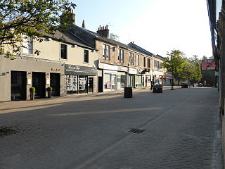
Milngavie is a town in East Dunbartonshire, Scotland and a suburb of Glasgow. It is on the Allander Water, at the northwestern edge of Greater Glasgow, and about ten kilometres from Glasgow city centre. It neighbours Bearsden. Milngavie is a commuter town, with much of its working population travelling to Glasgow to work or study. The town is served by Milngavie railway station on the North Clyde Line of the SPT rail network, which links it to Central Glasgow.

East Dunbartonshire is one of the 32 council areas of Scotland. It borders Glasgow City Council Area to the south, North Lanarkshire to the east, Stirling to the north, and West Dunbartonshire to the west. East Dunbartonshire contains many of the suburbs in the north of Greater Glasgow, including Bearsden, Milngavie, Bishopbriggs, Kirkintilloch, Lenzie, Twechar, Milton of Campsie, Balmore, and Torrance, as well as some other of Glasgow's commuter towns and villages. The council area covers parts of the historic counties of Dunbartonshire, Lanarkshire, and Stirlingshire.

North Lanarkshire is one of the 32 council areas of Scotland. It borders the north-east of the Glasgow City council area and contains many of Glasgow's suburbs, commuter towns, and villages. It also borders East Dunbartonshire, Falkirk, Stirling, South Lanarkshire, and West Lothian. The council area covers parts of the historic counties of Dunbartonshire, Lanarkshire, and Stirlingshire. The council is based in Motherwell.
Bearsden is a town in East Dunbartonshire, Scotland, on the northwestern fringe of Greater Glasgow, approximately six miles from the city centre.

Stirlingshire or the County of Stirling is a historic county and registration county of Scotland. Its county town is Stirling.

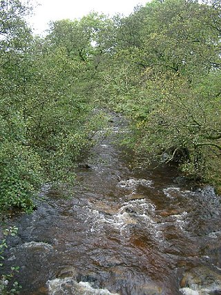
The River Kelvin is a tributary of the River Clyde in northern and northeastern Glasgow, Scotland. It rises on the moor south east of the village of Banton, east of Kilsyth. At almost 22 miles (35 km) long, it initially flows south to Dullatur Bog where it falls into a man made trench and takes a ninety degree turn flowing west through Strathkelvin and along the northern boundary of the bog parallel with the Forth and Clyde Canal.

Clydebank and Milngavie is a constituency of the Scottish Parliament covering part of the council areas of East Dunbartonshire and West Dunbartonshire. It elects one Member of the Scottish Parliament (MSP) by the first past the post method of election. It is also one of ten constituencies in the West Scotland electoral region, which elects seven additional members, in addition to the ten constituency MSPs, to produce a form of proportional representation for the region as a whole.

Mugdock Country Park is a country park and historical site located partly in East Dunbartonshire and partly in Stirling, in the former county of Stirlingshire, Scotland. It is around 10 miles north of Glasgow, next to Milngavie, and covers an area of 260 hectares.

Baldernock meaning 'settlement of St Earnaig' is a small parish in East Dunbartonshire, Scotland, ten miles (16 km) to the north of Glasgow's city centre.
Balmore is a small village formerly in the county of Stirlingshire, but now lies in East Dunbartonshire, Scotland, located 1 km west of Torrance and 5 km east of Milngavie.
Addinston is a farming village, off the A697, close to the Carfraemill roundabout, with two hill forts and settlements, in Lauderdale in the Scottish Borders area of Scotland, in the former Berwickshire.
Paxton is a small village near the B6461 and the B6460, in the pre-1975 ancient county of Berwickshire, now an administrative area of the Scottish Borders region of Scotland. It lies 1 mile west of the border with Northumberland, near Berwick-upon-Tweed. It is a traditional, country village surrounded by farmland, and its closest market towns are Duns and Berwick-upon-Tweed.

The Kilpatrick Hills are a range of hills in central Scotland, stretching from Dumbarton in the west to Strathblane in the east.
The Caddon Water is a small river by the village of Caddonfoot, in the Scottish Borders area of Scotland. It rises on Windlestraw Law, four miles north of Innerleithen, and flows through the Stantling Craig Reservoir. It joins the river Tweed at Caddonfoot, having completed its journey after 11 miles (18 km).
The Blackcastle Rings are earthworks and a promontory fort in the Parish of Greenlaw, above the left bank of the Blackadder Water, in the Scottish Borders area of Scotland.
The Hermitage Water is a river in Liddesdale, in the Scottish Borders area of Scotland. Among its many feeder burns are Braidley Burn, Dinley Burn, Gorrenberry Burn and Twislehope Burn. The Water flows through the hamlets of Dinley and Gorrenberry, and through the village of Hermitage, and past Hermitage Castle. It continues past Toftholm where it meets the B6399, and passes Newlands, Longhaugh, Leahaugh and Redheugh. At Sandholm it joins the Liddel Water and the dismantled railway.

Clintmains is a village by the River Tweed, in the parish of Mertoun, to the east of Newtown St Boswells, in the Scottish Borders area of Scotland, in the former county of Berwickshire.
Allanbank is a village near Allanton, in the Scottish Borders area of Scotland, in the historic county of Berwickshire.

Cranshaws is a village on the B6355 road, near Duns, in the Scottish Borders area of Scotland, in the former Berwickshire.
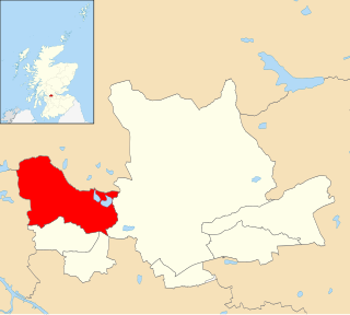
Milngavie is one of the seven wards used to elect members of the East Dunbartonshire Council. It elects three Councillors. Its territory consists of the entire burgh of Milngavie, and a sparsely populated hinterland to its north-west, bordering the West Dunbartonshire and Stirling local authority areas. In 2020, the ward had a population of 13,572.

