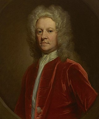
Simon Fraser, 11th Lord Lovat, c. 1667 – 9 April 1747, was a Scottish clan chief and head of Clan Fraser of Lovat. Convicted of high treason for his role in the Jacobite rising of 1745, he was the last man in Britain to be executed by beheading.
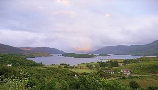
Loch Morar is a freshwater loch in the Rough Bounds of Lochaber, Highland, Scotland. It is the fifth-largest loch by surface area in Scotland, at 26.7 km2 (10.3 sq mi), and the deepest freshwater body in the British Isles with a maximum depth of 310 m (1,017 ft). The loch was created by glacial action around 10,000 years ago, and has a surface elevation of 9 metres (30 ft) above sea level. It separates the traditional district of North Morar, from Arisaig and Moidart.
Braemar is a village in Aberdeenshire, Scotland, around 58 miles (93 km) west of Aberdeen in the Highlands. It is the closest significantly-sized settlement to the upper course of the River Dee, sitting at an elevation of 339 metres (1,112 ft).

Morar is a small village on the west coast of The Rough Bounds of Scotland, three miles south of Mallaig. The name Morar is also applied to the northern part of the peninsula containing the village, though North Morar is more usual. The coastline of the area forms part of the Morar, Moidart and Ardnamurchan National Scenic Area, one of 40 such areas in Scotland, which are defined so as to identify areas of exceptional scenery and to ensure its protection by restricting certain forms of development.
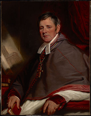
Hugh MacDonald was a Roman Catholic bishop who served as the Vicar Apostolic of the Highland District for the strictly illegal and underground Catholic Church in Scotland between 1731 and 1773.
Alexander Macdonell was an outlawed "heather priest" of the illegal Catholic Church in Scotland, the first Roman Catholic military chaplain in Post-Reformation British military history, and the first Roman Catholic Bishop of Kingston, Upper Canada.

Beauly is a village in Scotland's Highland area, on the River Beauly, 12 miles (19 km) west of Inverness by the Far North railway line. The town is historically within Kilmorack Parish of the County of Inverness.

The River Beauly is a river in the Scottish Highlands, about 15 km west of the city of Inverness.
The Knights of St Columba is a fraternal service order affiliated with the Catholic Church in Scotland, in England and Wales, and, through their Province of Liverpool, in the Isle of Man. Founded in Glasgow in 1919, the Knights are named in honour of Saint Columba, a 6th-century Celtic Church missionary descended from the Gaelic nobility of Ireland in modern County Donegal, who founded Iona Abbey and successfully evangelized both the Picts and Gaels of modern Scotland. The Knights describes themselves as dedicated to the principles of Charity, Unity and Fraternity. There are around 2400 members of the KSC, in over 200 councils across Great Britain — it features in England, Scotland and Wales. Membership is limited to Catholic men aged 16 and over, and promotes the social doctrine of the Catholic Church.

Cannich is a village at the southern end of Strathglass, in the Highlands of Scotland, about 26 miles (42 km) west of the city of Inverness. It is at the furthest point of the A831 that loops around the Aird from Beauly to Drumnadrochit.
Glen Strathfarrar is a glen in the Highland region of Scotland, near Loch Ness.
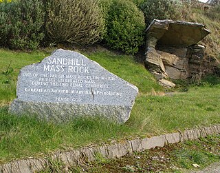
A Mass rock was a rock used as an altar by the Catholic Church in Ireland, during the 17th and 18th centuries, as a location for secret and illegal gatherings of faithful attending the Mass offered by outlawed priests. Similar altars, known as Mass stones, were used by the similarly illegal and underground Catholic Church in Scotland, membership in which was similarly criminalised by the Scottish Reformation Parliament in 1560.

The Scalan was a Scottish Catholic seminary and one of the few places where underground education by the Catholic Church in Scotland was kept alive during the anti-Catholic persecutions of the 16th-19th century.
William Fraser was a Canadian Roman Catholic priest and the first Bishop of Halifax in Nova Scotia from 1842 until the splitting of the diocese into two dioceses effective September 22, 1844, when William Walsh took formal possession of the Diocese of Halifax. Bishop Fraser, however, remains a celebrated figure in the Canadian Gaelic Bardic poetry composed in his Diocese and is still remembered as a legendary strongman in both his native district of Scotland and in Nova Scotia. In both countries, many tales have been collected of his exploits.
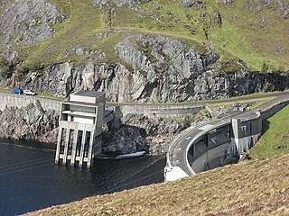
The Affric-Beauly hydro-electric power scheme for the generation of hydro-electric power is located in the western Highlands of Scotland. It is based around Glen Strathfarrar, Glen Cannich and Glen Affric, and Strathglass further downstream.

Glen Cannich is a long glen and Strath in the Northwest Highlands of Scotland and through which runs the River Cannich. Once densely populated before being largely emptied by both voluntary emigration and the Highland Clearances following the Battle of Culloden in 1746, the Glen, which was formerly the property of Clan Chisholm, has played an important role in the history of Scottish Gaelic literature, Scottish traditional music, and in the history, martyrology, and hymnography of the Catholic Church in Scotland. A minor public road runs up Glen Cannich from Cannich as far as the Mullardoch dam. Other than water capture for the Affric-Beauly hydro-electric power scheme, the major land uses in the glen are commercial forestry and deer stalking.
John Farquharson, was a member of the Scottish nobility who became an outlawed priest in the Northwest Highlands for the illegal Catholic Church in Scotland.

"Mo rùn geal òg", alternately known as "Cumha do dh'Uilleam Siseal" is a Scottish Gaelic lament written by Christina Fergusson for her husband, William Chisholm of Strathglass, who was killed at the Battle of Culloden in 1746.
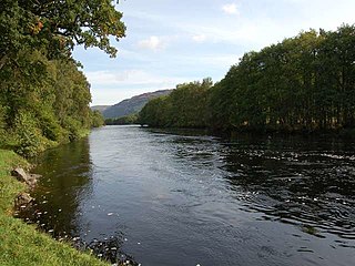
Strathglass is a strath or wide and shallow valley in the Northwest Highlands of Scotland down which runs the meandering River Glass from the point at which it starts at the confluence of the River Affric and Abhainn Deabhag to the point where, on joining with the River Farrar at Struy, the combined waters become the River Beauly.

Alexander Cameron of Lochiel, S.J. was a Scottish nobleman, who became a Roman Catholic priest of the Society of Jesus.

