Scotland occupies the northern part of the British Isles. The landscape of the country is diverse; ranging from rugged mountain terrain to arable flat land with many rivers and lochs.
Scotland occupies the northern part of the British Isles. The landscape of the country is diverse; ranging from rugged mountain terrain to arable flat land with many rivers and lochs.
The flora of Scotland is typical of the northern European part of the Palearctic realm. Prominent among Scotland's sub-biomes are the boreal Caledonian Forest, heather moorland and coastal machairs. The forest once covered almost all of Scotland but now only 1% of the forest remains in 35 isolated areas.
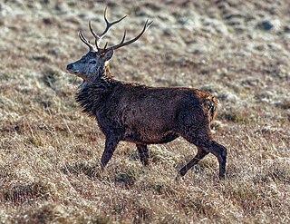
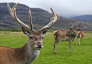
Scotland's environment supports 62 species of wild mammals, including wild cats, grey and harbour seals and the most northerly colony of bottlenose dolphins. The black and red grouse populate Scotland's moorland and the country has significant nesting grounds for seabirds. The Scottish crossbill is the only endemic vertebrate species in the UK. Scotland's seas are among the most biologically productive in the world with at least 40,000 species are estimated to live in Scottish waters. 14,000 species of insect inhabit Scotland, including rare species. The population of large mammals rapidly decreased to extinction in historic times.
The climate of Scotland is classified as temperate and tends to be very changeable. Warm air from the Gulf Stream makes Scotland's climate much warmer than other areas on similar latitudes. For example, in Labrador, Canada the sea freezes over in winter and icebergs are a common feature in spring and early summer or Fort McMurray, Canada where -35 °C is not uncommon during winter.
As Scotland occupies the cooler northern section of Great Britain, temperatures are generally lower than the rest of the United Kingdom. The average maximum temperatures in Scotland are 5.0-5.7 °C in winter and 20-25 °C in summer. The coldest ever UK temperature of -27.2 °C was recorded at Braemar in the Grampian Mountains on 10 January 1982 and at Altnaharra, Highlands on 30 December 1985. [1] The hottest temperature ever recorded in Scotland of 32.9 °C was recorded at Greycrook, Scottish Borders on 9 August 2003. [1]
Rainfall varies widely throughout Scotland. The western highlands of Scotland are one of the wettest places in Europe with annual rainfall up to 4577mm. [2] This type of precipitation is orographic in nature. Wet, warm is forced to rise on contact with the mountainous coast, where it cools and condenses forming clouds. Much of eastern Scotland receives less than 870mm annually in comparison. Snowfall is less common in lowland areas but becomes increasingly more common with altitude. [3]
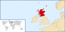
Scotland is located in north-west Europe and comprises the northern third of the island of Great Britain. Scotland is surrounded by 790 islands incorporating the major archipelagos of the Shetland Islands, the Orkney Islands and the Outer Hebrides. [4]
Scotland's only land border is with England. It runs 96 kilometres (60 miles) in a north-easterly direction from the Solway Firth in the west to the North Sea on the east coast. [5] The island of Ireland lies 30 kilometres (19 miles) from the south-west tip of the Scottish mainland. [5] Norway is located 305 kilometres (190 miles) to the north-east of Scotland across the North Sea.
The total area of Scotland is 78,772 km2 (30,414 sq mi). Scotland has 11,800 kilometres (7,300 miles) of coastline.
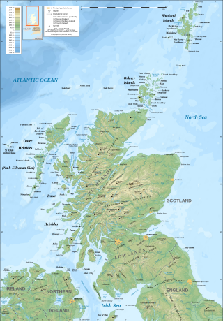
There are three main geographical sub-divisions in Scotland separated by two boundary fault lines. The Highlands and Islands (commonly abbreviated to the Highlands) lies to the north and west of the Highland Boundary Fault. The Central Lowlands and the Southern Uplands lie to the south of this fault line. The Southern Uplands Fault separates these two geographical areas.
The Highlands, which make up about 60% of Scotland, are extensive mountainous areas rising to peaks of about 1,300 metres (4,300 feet). By international standards, Scotland's mountains are not high, but their exposure to changeable and very unpredictable weather influenced by the meeting of European and Atlantic air streams gives them seriousness that is out of proportion with their height. The Grampian Mountains is a mountain range that is to the east of the Great Glen. The mountains are characterised by their large areas of upland plateau. The city of Aberdeen and the nearby surrounding area is more like the Central Lowlands as their fertile plains are not similar to the rest of the highlands.
The Central Lowlands make up 20% of Scotland and include the Forth-Clyde Canal. The area became home of widespread industrialisation from the late 18th century onwards. This was based on the large reserves of coal and iron ore found in the Central Lowlands, which was supported by the development of canals and railways.
The remaining 20% of Scotland is made up of the Southern Uplands, a pastoral upland area characterised by lines of hills divided by broad valleys. In addition to the main upland zones, there are individual hills that are not part of any ranges. Several of these hills are volcanic in origin and are known by the Scots word law. Examples of these include the North Berwick Law and the Traprain Law.
The west coast of Scotland, in particular, is heavily indented and is scattered with fjord-like sea lochs. The east coast is more regular with series of large estuarine inlets, or firths, and long sandy beaches. Much of Scottish coastline consists of machairs, a dune pasture land formed as sea levels subsided.
Scotland is bordered to the east by the North Sea and to the north and west by the Atlantic Ocean. Scotland has many rivers, lochs, reservoirs and estuaries. The River Tay is Scotland's longest river and is 193 kilometres (120 miles) long. Lakes in Scotland are known as lochs, with the exception of the Lake of Menteith and a few man-made lakes. The largest loch is Loch Lomond and is 71.1 km2 (27.5 sq mi) in area and is Britain's largest freshwater body.
In Scotland, water is a plentiful resource. Scotland's numerous lochs and rivers provide all of Scotland's water needs. Like most countries, tap water is treated with chlorine to make it safe to drink. Unlike other countries, tap water charges are included in council tax.
Climate change poses a major threat to Scotland. Tackling climate change in Scotland is a devolved issue for the Scottish government, separate from the UK government. In 2009, the Scottish Parliament passed the Climate Change (Scotland) Act 2009. [6] The act includes the framework for the reduction of greenhouse gas emissions and other duties for government ministers.
Climate change has already affected Scotland. Over fifty years, the frequency of winter storms has doubled. The UK has seen nine of the ten warmest summers since 1990. Sea levels in Scotland have risen by 10 cm since 1900.
Site-specific nature conservation began in the UK with the creation of the Nature Conservancy in 1948, which later became the Nature Conservancy Council (NCC). It moved from a research-based advisory group to become a campaigning body. The 1949 National Parks and Access to the Countryside Act excluded Scotland, but introduced the concept of Sites of Special Scientific Interest (SSSI), which were to become a key part of managing nature conservation. [7] A Countryside Commission Scotland (CSS) was established under the Countryside (Scotland) Act 1967. [8] The SSSI were strengthened by the Wildlife and Countryside Act 1981, which for the first time introduced the concept of payments to farmers for inactivity in relation to specific sites and shifted the burden of proof from conservationists having to prove harm, to landholders having to prove that harm was not taking place. The NCC was broken up in 1991 and in Scotland was merged with CSS to produce Scottish Natural Heritage (SNH), under a UK-wide Joint Nature Conservation Committee. SNH has a remit for both land and nature conservation and a responsibility towards sustainability and to the consideration of the needs of the Scottish people. [7]
The Scottish Environment Protection Agency was established by the Environment Act 1995, and took over the functions in Scotland of the river purification boards, waste regulation authorities and the Industrial Pollution Inspectorate. Its responsibilities include the water environment, air pollution, waste regulation, industrial pollution, radioactive substances and flood risk management.

Panama is a country located in Caribbean, bordering both the Caribbean Sea and the Pacific Ocean, between Colombia and Costa Rica. Panama is located on the narrow and low Isthmus of Panama.

The Highlands is a historical region of Scotland. Culturally, the Highlands and the Lowlands diverged from the Late Middle Ages into the modern period, when Lowland Scots language replaced Scottish Gaelic throughout most of the Lowlands. The term is also used for the area north and west of the Highland Boundary Fault, although the exact boundaries are not clearly defined, particularly to the east. The Great Glen divides the Grampian Mountains to the southeast from the Northwest Highlands. The Scottish Gaelic name of A' Ghàidhealtachd literally means "the place of the Gaels" and traditionally, from a Gaelic-speaking point of view, includes both the Western Isles and the Highlands.

The United Kingdom is a sovereign state located off the north-western coast of continental Europe. The United Kingdom is made up of four countries – England, Scotland, Wales and Northern Ireland. With a total area of approximately 244,376 square kilometres (94,354 sq mi), the UK occupies the major part of the British Isles archipelago and includes the island of Great Britain, the north-eastern one-sixth of the island of Ireland and many smaller surrounding islands. It is the world's 7th largest island country. The mainland areas lie between latitudes 49°N and 59°N, and longitudes 8°W to 2°E. The Royal Observatory, Greenwich, in south-east London, is the defining point of the Prime Meridian.
An environmentally sensitive area (ESA) is a type of designation for an agricultural area which needs special protection because of its landscape, wildlife or historical value. The scheme was introduced in 1987. Originally it was administered by Ministry of Agriculture, Fisheries and Food, then the Rural Development Service for the United Kingdom Governments Department for Environment, Food and Rural Affairs, and currently Natural England following successive re-organisation of the departments. In 2005 the scheme was superseded by Environmental Stewardship and closed to new entrants. Existing agreements remain active until they expire, meaning the designation will remain active until 2014.

Loch Lomond and The Trossachs National Park is a national park in Scotland centred on Loch Lomond and the hills and glens of the Trossachs, along with several other ranges of hills. It was the first of the two national parks established by the Scottish Parliament in 2002, the second being the Cairngorms National Park. The park extends to cover much of the western part of the southern highlands, lying to the north of the Glasgow conurbation, and contains many mountains and lochs. It is the fourth-largest national park in the British Isles, with a total area of 1,865 km2 (720 sq mi) and a boundary of some 350 km (220 mi) in length. It features 21 Munros and 20 Corbetts.

Cairngorms National Park is a national park in northeast Scotland, established in 2003. It was the second of two national parks established by the Scottish Parliament, after Loch Lomond and The Trossachs National Park, which was set up in 2002. The park covers the Cairngorms range of mountains, and surrounding hills. Already the largest national park in the United Kingdom, in 2010 it was expanded into Perth and Kinross.
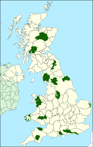
National parks of the United Kingdom are 15 areas of relatively undeveloped and scenic landscape across the country. Despite their name, they are quite different from national parks in many other countries, which are usually owned and managed by governments as protected community resources, and which do not usually include permanent human communities. In the United Kingdom, an area designated as a national park may include substantial settlements and human land uses that are often integral parts of the landscape. Land within national parks remains largely in private ownership. These parks are therefore not "national parks" according to the internationally accepted standard of the IUCN but they are areas of outstanding landscape where planning controls are a little more restrictive than elsewhere.

Loch Shiel is a freshwater loch situated 20 kilometres (12 mi) west of Fort William in the Highland council area of Scotland. At 28 kilometres long it is the 4th longest loch in Scotland, and is the longest to have retained a natural outflow without any regulation of its water level, being 120 m (393 ft) deep. Its nature changes considerably along its length, being deep and enclosed by mountains in the north east and shallow surrounded by bog and rough pasture in the south west, from which end the 4 km River Shiel drains to the sea in Loch Moidart near Castle Tioram.

The Southern Uplands are the southernmost and least populous of mainland Scotland's three major geographic areas. The term is used both to describe the geographical region and to collectively denote the various ranges of hills and mountains within this region. An overwhelmingly rural and agricultural region, the Southern Uplands are partly forested and contain many areas of open moorland - the hill names in the area are congruent with these characteristics.
Natural history of Scotland concerns the flora, fauna and mycota of Scotland.
The geography of Scotland is varied from rural lowlands to unspoilt uplands, and from large cities to sparsely inhabited islands. Located in Northern Europe, Scotland comprises the northern part of the island of Great Britain as well as 790 surrounding islands encompassing the major archipelagos of the Shetland Islands, Orkney Islands and the Inner and Outer Hebrides. The only land border is with England, which runs for 96 miles in a northeasterly direction from the Solway Firth in the west to the North Sea on the east coast. Separated by the North Channel, the island of Ireland lies 13 nautical miles from Mull of Kintyre on the Scottish mainland. Norway is located 190 nmi (350 km) northeast of Scotland across the North Sea. The Atlantic Ocean, which fringes the coastline of western and northern Scotland and its islands, influences the temperate, maritime climate of the country.

The geology of Scotland is unusually varied for a country of its size, with a large number of different geological features. There are three main geographical sub-divisions: the Highlands and Islands is a diverse area which lies to the north and west of the Highland Boundary Fault; the Central Lowlands is a rift valley mainly comprising Palaeozoic formations; and the Southern Uplands, which lie south of the Southern Uplands Fault, are largely composed of Silurian deposits.
The fauna of Scotland is generally typical of the northwest European part of the Palearctic realm, although several of the country's larger mammals were hunted to extinction in historic times and human activity has also led to various species of wildlife being introduced. Scotland's diverse temperate environments support 62 species of wild mammals, including a population of wild cats, important numbers of grey and harbour seals and the most northerly colony of bottlenose dolphins in the world.

The flora of Scotland is an assemblage of native plant species including over 1,600 vascular plants, more than 1,500 lichens and nearly 1,000 bryophytes. The total number of vascular species is low by world standards but lichens and bryophytes are abundant and the latter form a population of global importance. Various populations of rare fern exist, although the impact of 19th-century collectors threatened the existence of several species. The flora is generally typical of the north-west European part of the Palearctic realm and prominent features of the Scottish flora include boreal Caledonian forest, heather moorland and coastal machair. In addition to the native species of vascular plants there are numerous non-native introductions, now believed to make up some 43% of the species in the country.

Agriculture in Scotland includes all land use for arable, horticultural or pastoral activity in Scotland, or around its coasts. The first permanent settlements and farming date from the Neolithic period, from around 6,000 years ago. From the beginning of the Bronze Age, about 2000 BCE, arable land spread at the expense of forest. From the Iron Age, beginning in the seventh century BCE, there was use of cultivation ridges and terraces. During the period of Roman occupation there was a reduction in agriculture and the early Middle Ages were a period of climate deterioration resulting in more unproductive land. Most farms had to produce a self-sufficient diet, supplemented by hunter-gathering. More oats and barley were grown, and cattle were the most important domesticated animal. From c. 1150 to 1300, the Medieval Warm Period allowed cultivation at greater heights and made land more productive. The system of infield and outfield agriculture may have been introduced with feudalism from the twelfth century. The rural economy boomed in the thirteenth century, but by the 1360s there was a severe falling off in incomes to be followed by a slow recovery in the fifteenth century.

Loch Alsh is a sea inlet between the isle of Skye in the Inner Hebrides and the Northwest Highlands of Scotland. The name is also used to describe the surrounding country and the feudal holdings around the loch. The area is rich in history, and is increasingly popular with tourists.

South Lewis, Harris and North Uist is a large national scenic area (NSA) in the Western Isles of Scotland. It is one of 40 such areas in Scotland, which are defined so as to identify areas of exceptional scenery and to ensure its protection from inappropriate development. The designated area covers 202,388 ha in total, of which 112,301 ha is on land, with a further 90,087 ha being marine, making it the largest of the NSAs in both total and marine area. The designated area includes the mountainous south west of Lewis, all of Harris, the Sound of Harris and the northern part of North Uist.

Loch Druidibeag is a freshwater loch situated on the island of South Uist, in the Outer Hebrides of Scotland. The loch is near the northern end of the island, to the north-east of Howmore and to the east of the A865 road and south of the B890.

Ben Nevis and Glen Coe is a national scenic area (NSA) covering part of the Highlands of Scotland surrounding Ben Nevis and Glen Coe, in which certain forms of development are restricted. It is one of 40 such areas in Scotland, which are defined so as to identify areas of exceptional scenery and to ensure their protection from inappropriate development. The Ben Nevis and Glen Coe NSA covers 903 km2 (349 sq mi) of land, lying within the Highland, Argyll and Bute and Perth and Kinross council areas. A further 19 km2 (7.3 sq mi) of the NSA are marine, covering the sea loch of Loch Leven.
This article gives an overview of the structure of environmental and cultural conservation in Scotland, a constituent country of the United Kingdom.
{{cite web}}: CS1 maint: archived copy as title (link) Rainfall Amount Annual Average{{cite web}}: CS1 maint: archived copy as title (link) Snowfall map| Physical | |||||||
|---|---|---|---|---|---|---|---|
| Environment | |||||||
| Land use | |||||||
| Administrative |
| ||||||
| Social | |||||||