Annick Water

Last updated
Annick Water
Annickwatercunnighamhead.JPG
The Annick Water
near Cunninghamhead mill
Location
Country Scotland
Physical characteristics
Source 
  location Long Loch (East Renfrewshire)
Mouth River Irvine
  location
Irvine, North Ayrshire, Scotland
  coordinates
55°36′14″N4°39′40″W / 55.60393°N 4.66110°W / 55.60393; -4.66110 Coordinates: 55°36′14″N4°39′40″W / 55.60393°N 4.66110°W / 55.60393; -4.66110
The Annick Water looking upstream from Chapeltoun Bridge. Annickwater1.JPG
The Annick Water looking upstream from Chapeltoun Bridge.

The Annick Water (previously also spelled as Annack, Annoch (1791) or Annock) is the largest tributary of the River Irvine. The river runs from Long Loch, just inside East Renfrewshire, in a generally south-western direction through North Ayrshire and East Ayrshire, to confluence with its parent river at Irvine, North Ayrshire on the west coast of Scotland. The name may derive from the Gaelic for 'overflowing' [1] and Strathannick is very much prone to flooding as recorded by SEPA.

Contents

The water now (2006) appears to be pollution free for most of its length. An independent survey in the Bourtreehill (1999) area revealed a strong colony of freshwater shrimp, a crustacean known only to live in relatively clean water.

On 27 January 2009 a BP tanker train carrying liquid fuels (diesel and heating oil) from Mossend to Riccarton was derailed near the bridge over the Stewarton to Kilmaurs road at Peacockbank Farm. Several wagons subsequently caught fire. [2] The Annick Water was polluted, however, it escaped major contamination.


History

The dismantled bridge at Lainshaw after the drowning in 2007. Lainshaw old bridge.jpg
The dismantled bridge at Lainshaw after the drowning in 2007.
The bridge and weir below Lainshaw House. LainshawAnnickweir.JPG
The bridge and weir below Lainshaw House.

Mesolithic man used the Annick as his waterway. From Bourtreehill to Dreghorn, the Annick has presented us with many artifacts dating from that time. Indeed, recent archaeological evidence from Dreghorn uncovered the oldest continually used settlement in Europe. This mesolithic village was on the banks of the Annick.

A number of mills existed along its length with only Cunninghamhead Mill still standing today (2006). Lambroch Mill was located near Laigh Castleton Farm. Scroaggy or Fairliecrevoch Mill was a waulk or cloth mill and existed until the 1960s, with its lade cutting across the large loop in the river near Ramstane. Downstream from Cunninghamhead was a sawmill and a corn mill existed in Perceton near the old church. Scroag or scrog is a crab apple or gnarled treestumps in old Scots and this 'nickname' well describes the area where the mill stood.

A number of fords and stepping stones are present, notably at Chapeltoun, Lambroch Mill, and at Ramstane where a footbridge was also present. A footbridge is still present at Laigh Castleton and a weir existed close to Lainshaw House, raising the water level to form an area which was ideal for water fowl. A small weir is still present beneath the surviving bridge into the Lainshaw Holm. Wooden carriageway bridges existed at two places on the Lainshaw estate; the stone built abutments are still visible.

A number of old bridges cross the Annick Water along its entire length, such as at Stewarton and Chapeltoun. Notable is the 17th century remains of bridge-supports in Bourtreehill's own stretch of the Annick. Other early railway bridges cross its shallow and easy waters. The lower reaches were known as Strathannick in the 18th century, but the name has sadly gone out of use.

Helicopter searching the Annick Water at Lambroughton in 2007. RAFLamb.JPG
Helicopter searching the Annick Water at Lambroughton in 2007.

Death on the Annick

Memorial flowers, etc. at the Annick Water below Lainshaw House. LainshawAnnickmemorial.JPG
Memorial flowers, etc. at the Annick Water below Lainshaw House.

During a particularly long feud between the Cunningham and Montgomery families in the 16th and 17th centuries, the fourth Earl of Eglinton was murdered at a ford on the Annick at Bridgend in Stewarton.

The river can be dangerous and a gravestone in Dreghorn Parish Church records the death by drowning of a young lad from Perceton in Victorian times.

On 18 August 2007 a Stewarton boy, Dean McGregor, [3] fell into the Annick Water when it was in flood. The scene of the tragedy was near Lainshaw House. An RAF 'Search and Rescue' helicopter from HMS Gannet searched the river for several hours, unsuccessfully. The body was found in the river a few days later near the sewerage works.

Wildlife

North American mink have been sighted along the banks of the Annick. This aggressive animal was unfortunately introduced to Britain and has been the cause for much concern for many years.

Kingfishers have been spotted flying above the surface of the water, successfully catching small fish in their beaks.

The eel, which originates in the Sargasso Sea has been known to cross land at certain sections of the Annick River. This is a common habit of the eel but the sight is rather odd.

As well as some Trout and Salmon it has a healthy population of Sticklebacks, Minnows, Freshwater Shrimps, Freshwater Limpets, Caddisfly Larvae, Blackfly, Stonefly and Leeches, indicating that the water quality is good. Mallard and heron are frequently encountered and the occasional Great Crested Grebe can be seen. Eels are sometimes to be found on land, especially in wet weather, taking a shortcut across the top of the lengthy loops that are found in the river in the area.

Marchantia polymorpha, the Common Liverwort grows on the bare bedrock dykes of the Annick near Cunninghamhead Mill, this plant being much rarer than the name suggests. Pellia epiphyla and Lunularia liverworts grow on the earth riverside banks at Cunninghamhead and elsewhere. The riverside vegetation includes Butterburr, Reed-Canary Grass, Rushes, Water Forget-Me-Not, Brooklime-Speedwell, Giant Hogweed, Hemlock Water-Dropwort, Willows and Alders.

See also

Related Research Articles

Dreghorn

Dreghorn is a village in North Ayrshire, Scotland, 3.5 kilometres (2.2 mi) to the east of Irvine town centre, on the old main road from Irvine to Kilmarnock. It is sited on a ridge between two rivers. As archaeological excavations near the village centre have found a significant neolithic settlement provisionally dated to around 3500BC, as well as medieval structures, scholars have suggested that Dreghorn could be Britain's oldest continuously inhabited village. Both Irvine and Dreghorn have grown in size and they are now separated by the Annick Valley Park, which incorporates a footpath and National Cycle Route 73 on the route of the disused Irvine to Busby railway line. It had an estimated population of 3,540 in 2016.

Stewarton Town in Scotland

Stewarton is a town in East Ayrshire, Scotland. In comparison to the neighbouring towns of Kilmaurs, Fenwick, Dunlop and Lugton, it is a relatively large town, with a population estimated at over 7,400. It is 300 feet above sea level. The town is served by Stewarton railway station.

Perceton is a medieval settlement and old country estate in North Ayrshire, Scotland, near the town of Irvine. The ruined church in Perceton is one of the oldest buildings in the Irvine district. The earliest legible gravestone dates from 1698, though older stone coffins will certainly still rest deep within the small hillock on which the chapel and graveyard sit.

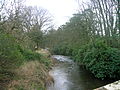
Chapeltoun is an estate on the banks of the Annick Water in East Ayrshire, Scotland. This is a rural area famous for its milk and cheese production and the Ayrshire or Dunlop breed of cattle.

Lambroughton Human settlement in Scotland

Lambroughton is a village in the old Barony of Kilmaurs, Scotland. This is a rural area famous for its milk and cheese production and the Ayrshire or Dunlop breed of cattle.

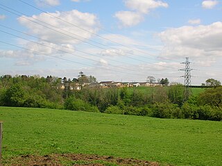
Cunninghamhead is a hamlet in North Ayrshire, Scotland. It was the centre of the lands of Cunninghamhead, Perceton and Annick Lodge in Cunninghame. This mainly rural area is noted for its milk and cheese production and the Ayrshire, Cunninghame or Dunlop breed of cattle.

Barony and Castle of Corsehill Barony in East Ayrshire, Scotland

The old Barony and castle of Corsehill lay within the feudal Baillerie of Cunninghame, near Stewarton, now East Ayrshire, Scotland.

Cunninghamhead railway station

Cunninghamhead railway station (NS369414) was a railway station serving Cunninghamhead Estate, the village of Crossroads, North Ayrshire and the town of Stewarton, East Ayrshire, Scotland. The station was originally part of the Glasgow, Paisley, Kilmarnock and Ayr Railway.

Cunninghamhead Estate

The Cunninghamhead Estate is in the 21st century mainly a residential caravan park with two private residences near Irvine, Scotland. It was once a private estate, owned by a sequence of recorded families since around 1418. The Mansion House, one of Britain's lost houses, was built in 1747; it was destroyed by fire in the early 1960s, whilst renovation work was being carried out. The old mansion and castle have been lost, however the stables are still a residence, whilst the Gardner's Cottage survive as ruins. From 1964, work was carried out, first to use the estate as a chicken farm and later as holiday and residential, caravan park and camping site, making most of the rural location. Circa 2003 the site was significantly redeveloped to become a residential caravan park exclusively for the use of retired and semi-retired persons.

Cunninghamhead Human settlement in Scotland

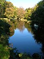
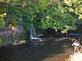
Cunninghamhead is a hamlet on the Annick Water in the Parish of Dreghorn, North Ayrshire, Scotland. The area was part of the old Cunninghamhead estate, and once contained several watermills.

Annick Lodge is an estate between Perceton and Cunninghamhead in North Ayrshire, Scotland.

The village of Springside is in North Ayrshire, Parish of Dreghorn, Scotland. It is three miles from Irvine, 1 12 miles (2.4 km) west of Crosshouse and four miles from Kilmarnock. In the 18th, 19th and mid-20th centuries, the locality was a highly industrialised coal mining district. The settlement is on the Garrier Burn, which forms the boundary with East Ayrshire. Springside had a population of around 1364 in 1991. The A71 now bypasses the village, 14 mile (0.40 km) to the south.

River Irvine

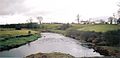
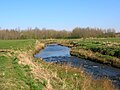
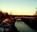
The River Irvine is a river that flows through southwest Scotland. Its watershed is on the Lanarkshire border of Ayrshire at an altitude of 810 feet (250 m) above sea-level, near Loudoun Hill, Drumclog, and 7 miles SW by W of Strathaven. It flows 29 12 mi (47.5 km) westward, dividing the old district of Cunninghame from that of Kyle, until it reaches the sea via Irvine Harbour in the form of the Firth of Clyde, and flows into Irvine Bay by the town of Irvine. It has many tributaries, some of which form parish, district and other boundaries.

Girdle Toll Human settlement in Scotland

Girdle Toll is an area of Irvine, North Ayrshire.

The Irvine New Town Trail is a recreational cycleway and footpath around Irvine, North Ayrshire, Scotland. The route is 19 kilometres (12 mi) long. The trail is used by many dog walkers and cyclists in the area.

Kennox House

Kennox House is situated on Kilwinning Road between Stewarton to Torranyard in North Ayrshire, Parish of Dunlop, Scotland. The house overlooks the Glazert Burn, which runs into the Annick Water at Watermeetings.

Castle and Barony of Robertland

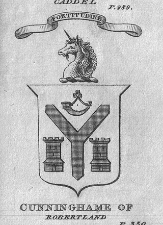
The Castle and Barony of Robertland is located near Stewarton, off the B769 road, in the old district of Cunninghame, Parish of Stewarton, and now part of East Ayrshire, Scotland.

Lands of Lainshaw

The Lands of Lainshaw lie in Strathannick and were part of the Lordship of Stewarton, in East Ayrshire, Scotland. Lainshaw House is a category B listed mansion, lying in a prominent position above the Annick Water and its holm in the Parish of Stewarton, Scotland. Part of the much older Lainshaw Castle is contained within the several later building phases of the present day Lainshaw House. The names 'Langshaw' or 'Langschaw' were used in historic times. Law Mount near the High and Laigh Castleton farms has been suggested as the site of the original castle, granted in the 12th century to Godfrey de Ross by Hugo de Morville.

Lands of Broomlands Human settlement in Scotland

The lands of Broomlands or Broumlands formed a small country estate about a mile to the east of Irvine, North Ayrshire, Scotland situated on the east bank of the Annick Water in the Parishes of Dreghorn and Irvine.

Lawthorn Human settlement in Scotland

Lawthorn is a hamlet near Perceton in Strathannick, Irvine, North Ayrshire, Scotland. The settlement lies on the old Irvine to Stewarton toll road.

References

  1. Johnston, James B. (1903), Place-Names of Scotland. Pub. David Douglas, Edinburgh. P. 12.
  2. METRO. January 28, 2009. p. 5.
  3. Dean McGregor