
Urr Water or River Urr ( arc. River Orr) is a river in which flows through the counties of Dumfriesshire and Kirkcudbrightshire in southwest Scotland.
Urr Water or River Urr ( arc. River Orr) is a river in which flows through the counties of Dumfriesshire and Kirkcudbrightshire in southwest Scotland.
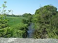
Entirely within Dumfries and Galloway, the Urr Water originates at Loch Urr and flows for thirty-five miles southwards past Corsock, Glenlair, Auchendolly, Bridge of Urr, Haugh of Urr, and close to Dalbeattie, via Palnackie to the Solway Firth at Rough Firth. The village of Kippford stands near the head of the firth where the Urr Water reaches the sea; the only other coastal settlement of any size is Rockcliffe. The principal settlement on the river is Dalbeattie. The river is noted for salmon fishing. [1]

The name 'Urr' is from Cumbric or 'a border, boundary, limit'. [2]


The River Clyde is a river that flows into the Firth of Clyde in Scotland. It is the ninth-longest river in the United Kingdom, and the third-longest in Scotland. It runs through the major city of Glasgow. Historically, it was important to the British Empire because of its role in shipbuilding and trade. To the Romans, it was Clota, and in the early medieval Cumbric language, it was known as Clud or Clut. It was central to the Kingdom of Strathclyde.

Dumfries and Galloway is one of 32 unitary council areas of Scotland and is located in the western Southern Uplands. It covers the historic counties of Dumfriesshire, Kirkcudbrightshire, and Wigtownshire, the latter two of which are collectively known as Galloway. The administrative centre and largest settlement is the town of Dumfries. The second largest town is Stranraer, on the North Channel coast, some 57 miles (92 km) to the west of Dumfries.

Kirkcudbrightshire, or the County of Kirkcudbright or the Stewartry of Kirkcudbright is one of the historic counties of Scotland, covering an area in the south-west of the country. Until 1975, Kirkcudbrightshire was an administrative county used for local government. Since 1975, the area has formed part of Dumfries and Galloway for local government purposes. Kirkcudbrightshire continues to be used as a registration county for land registration. A lower-tier district called Stewartry covered the majority of the historic county from 1975 to 1996. The area of Stewartry district is still used as a lieutenancy area. Dumfries and Galloway Council also has a Stewartry area committee.

The River Forth is a major river in central Scotland, 47 km (29 mi) long, which drains into the North Sea on the east coast of the country. Its drainage basin covers much of Stirlingshire in Scotland's Central Belt. The Gaelic name for the upper reach of the river, above Stirling, is Abhainn Dubh, meaning "black river". The name for the river below the tidal reach is Uisge For.

The River Dee, in south-west Scotland, flows from its source in Loch Dee amongst the Galloway Hills, firstly to Clatteringshaws Loch, then into Loch Ken, where it joins the Water of Ken. From there, the Dee flows 15 miles (24 km) southwards to Kirkcudbright, and into Kirkcudbright Bay to reach the Solway Firth. The distance is just over 38 miles (61 km) in total. Together with its tributaries, the Dee's total catchment area is over 400 square miles (1,000 km2).

The River Esk, also known as the Border Esk, is a river in Dumfries and Galloway, Scotland, that enters the English county of Cumbria and flows into the Solway Firth.

The River Swale in Yorkshire, England, is a major tributary of the River Ure, which becomes the River Ouse, that empties into the North Sea via the Humber Estuary. The river gives its name to Swaledale, the valley through which it flows.

The River Conwy is a river in northern Wales. From its source to its discharge in Conwy Bay it is 55 kilometres (34 mi) long and drains an area of 678 square km. "Conwy" was formerly anglicised as "Conway."

Dalbeattie is a town in the historical county of Kirkcudbrightshire in Dumfries and Galloway, Scotland. Dalbeattie is in a wooded valley on the Urr Water 4 miles (6 km) east of Castle Douglas and 12 miles (19 km) south west of Dumfries. The town is famed for its granite industry and for being the home town of William McMaster Murdoch, the First Officer of the RMS Titanic.

Buittle is an ecclesiastical and civil parish in Dumfries and Galloway, southwest Scotland, in the traditional county of Kirkcudbrightshire. It lies to the west of the Urr Water, between Dalbeattie and Castle Douglas, and extends from Haugh of Urr in the north to Almorness Point on the Solway Firth in the south. The main settlement is the small village of Palnackie.

The River Wiske is a tributary of the River Swale in Yorkshire, England. The Wiske gives its name to several villages it passes through. The name Wiske is derived from an Old English word wisca meaning a water meadow. It was once known as the Foulbroke, a name for which some writers commented that it was well deserved.

The River Eden is a river in Fife in Scotland, and is one of Fife's two principal rivers, along with the Leven. It is nearly 30 miles (48 km) long and has a fall of around 300 feet (91 m).

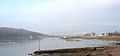
Hestan Island is a small coastal island at the southern foot of the River Urr estuary in the Solway Firth, in the historical county of Kirkcudbrightshire, Scotland. This small island measures approximately 460 by 270 metres and at its highest elevation sits at just over 50 metres above sea level.

The River Fergus is a river within the Shannon River Basin which flows in County Clare, Ireland. The river begins at Lough Fergus in north Clare and flows into the Shannon Estuary. The source is at Lough Fergus in the townland of Kilmore North.

Haugh of Urr, is a village in the historical county of Kirkcudbrightshire in Dumfries and Galloway, Scotland. It is approximately 4 miles NNW of Dalbeattie, 3 mi (5 km) NE of Castle Douglas, 12+1⁄2 mi (20 km) west of Dumfries and 12+1⁄2 mi (20 km) east of Kirkcudbright.
The Waitakaruru River is a river of the Waikato Region of New Zealand's North Island. It flows initially north before turning northwest across the northwestern corner of the Hauraki Plains, reaching the southwestern corner of the Firth of Thames close to the settlement of Waitakaruru.
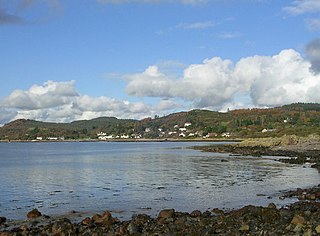
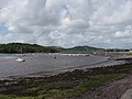
Rough Firth is an inlet on the northern coast of the Solway Firth in the Stewartry area of Dumfries and Galloway, Scotland. The firth lies between Almorness Point and Castlehill Point, and contains Rough Island. The village of Kippford stands near the head of the firth where the Urr Water reaches the sea; the only other coastal settlement of any size is Rockcliffe. The area is designated as the East Stewartry Coast National Scenic Area, one of the forty national scenic areas (NSAs) in Scotland.

Colvend and Southwick is a community council area and civil parish within the Stewartry area of Dumfries and Galloway, Scotland. It is also part of the Church of Scotland parish of Colvend, Southwick and Kirkbean. It is in the historic county of Kirkcudbrightshire.
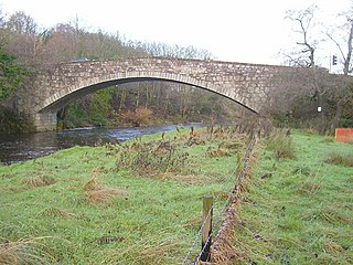
Buittle Bridge, also known as Craignair Bridge is a bridge over the Urr Water just outside Dalbeattie in Dumfries and Galloway, Scotland. Completed in 1797, it replaced and earlier two-span bridge of the same name which was destroyed in a flood a short time after its completion; the remains of this older bridge, comprising the base of its pier and some remnants of its south-west abutment, survive a short distance upstream.
Coordinates: 54°50′N3°50′W / 54.833°N 3.833°W
| | This Dumfries and Galloway location article is a stub. You can help Wikipedia by expanding it. |