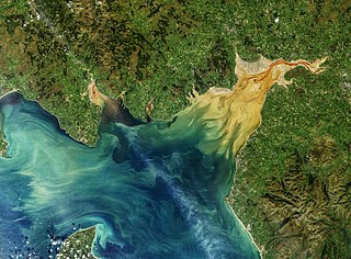
The Solway Firth is a firth that forms part of the border between England and Scotland, between Cumbria and Dumfries and Galloway. It stretches from St Bees Head, just south of Whitehaven in Cumbria, to the Mull of Galloway, on the western end of Dumfries and Galloway. The Isle of Man is also very near to the firth. The firth comprises part of the Irish Sea.

Dumfries is a market town and former royal burgh in Dumfries and Galloway, Scotland, near the mouth of the River Nith on the Solway Firth, 25 miles (40 km) from the Anglo-Scottish border. Dumfries is the county town of the historic county of Dumfriesshire.

Kirkcudbrightshire, or the County of Kirkcudbright or the Stewartry of Kirkcudbright is one of the historic counties of Scotland, covering an area in the south-west of the country. Until 1975, Kirkcudbrightshire was an administrative county used for local government. Since 1975, the area has formed part of Dumfries and Galloway for local government purposes. Kirkcudbrightshire continues to be used as a registration county for land registration. A lower-tier district called Stewartry covered the majority of the historic county from 1975 to 1996. The area of Stewartry district is still used as a lieutenancy area. Dumfries and Galloway Council also has a Stewartry area committee.

Isle of Whithorn is one of the most southerly villages and seaports in Scotland, lying on the coast north east of Burrow Head, about three miles from Whithorn and about thirteen miles south of Wigtown in Dumfries and Galloway. Whithorn,, is a former royal burgh in Wigtownshire, Dumfries and Galloway, with which Isle of Whithorn is frequently incorrectly amalgamated or confused. It is referred to locally as 'The Isle' - never 'the Isle of Whithorn'.

The River Nith is a river in south-west Scotland. The Nith rises in the Carsphairn hills of East Ayrshire, between Prickeny Hill and Enoch Hill, 4.4 miles (7.1 km) east of Dalmellington. For the majority of its 70 miles (110 km) course it flows in a south-easterly direction through Dumfries and Galloway and then into the Solway Firth at Airds Point.

Dalbeattie is a town in the historical county of Kirkcudbrightshire in Dumfries and Galloway, Scotland. Dalbeattie is in a wooded valley on the Urr Water 4 miles (6 km) east of Castle Douglas and 12 miles (19 km) south west of Dumfries. The town is famed for its granite industry and for being the home town of William McMaster Murdoch, the First Officer of the RMS Titanic.

The Southern Uplands are the southernmost and least populous of mainland Scotland's three major geographic areas. The term is used both to describe the geographical region and to collectively denote the various ranges of hills and mountains within this region. An overwhelmingly rural and agricultural region, the Southern Uplands are partly forested and contain many areas of open moorland - the hill names in the area are congruent with these characteristics.
Flounder tramping is a traditional method of catching flounder or other flat fish by wading in shallow water and standing on them.

Buittle is an ecclesiastical and civil parish in Dumfries and Galloway, southwest Scotland, in the traditional county of Kirkcudbrightshire. It lies to the west of the Urr Water, between Dalbeattie and Castle Douglas, and extends from Haugh of Urr in the north to Almorness Point on the Solway Firth in the south. The main settlement is the small village of Palnackie.

Urr Water or River Urr is a river in which flows through the counties of Dumfriesshire and Kirkcudbrightshire in southwest Scotland.

Hestan Island is a small coastal island at the southern foot of the River Urr estuary in the Solway Firth, in the historical county of Kirkcudbrightshire, Scotland. This small island measures approximately 460 by 270 metres and at its highest elevation sits at just over 50 metres above sea level.

Glencaple is a small settlement in the Dumfries and Galloway area of Scotland. Situated on the banks of the River Nith, it once served as a port for nearby Dumfries. Glencaple is a Gaelic name meaning 'horse valley' from the words gleann 'narrow valley' and capall 'horse, mare'.

Haugh of Urr, is a village in the historical county of Kirkcudbrightshire in Dumfries and Galloway, Scotland. It is approximately 4 miles NNW of Dalbeattie, 3 mi (5 km) NE of Castle Douglas, 12+1⁄2 mi (20 km) west of Dumfries and 12+1⁄2 mi (20 km) east of Kirkcudbright.
Mochrum is a coastal civil and Church of Scotland parish situated to the east of Luce Bay on the Machars peninsula and 8 miles (13 km) southwest of Wigtown and in the historical county of Wigtownshire in Galloway, Scotland. It covers 22,000 acres (8,900 ha) and is approximately 10 miles (16 km) in length and 5 miles (8.0 km) in breadth. The parish contains the eponymous village of Mochrum, as well as Port William and the clachan of Elrig.
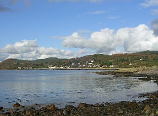
Rockcliffe is a small, coastal village in Kirkcudbrightshire, Dumfries and Galloway in Scotland, with a view of Rough Island, Hestan Island, the Solway Firth and sometimes the Cumbrian coast.

The River Cree is a river in Dumfries and Galloway, Scotland which runs through Newton Stewart and into the Solway Firth. It forms part of the boundary between the counties of Wigtownshire and Kirkcudbrightshire. The tributaries of the Cree are the Minnoch, Trool, Penkiln and Palnure which drain from the Range of the Awful Hand, the labyrinthine range of mountains and lochs, bogs, burns and crags, rising at its highest to The Merrick, Galloway, 12 miles north and visible from Newton Stewart.
Rough Firth is an inlet on the northern coast of the Solway Firth in the Stewartry area of Dumfries and Galloway, Scotland. The firth lies between Almorness Point and Castlehill Point, and contains Rough Island. The village of Kippford stands near the head of the firth where the Urr Water reaches the sea; the only other coastal settlement of any size is Rockcliffe. The area is designated as the East Stewartry Coast National Scenic Area, one of the forty national scenic areas (NSAs) in Scotland.

Colvend and Southwick is a community council area and civil parish within the Stewartry area of Dumfries and Galloway, Scotland. It is also part of the Church of Scotland parish of Colvend, Southwick and Kirkbean. It is in the historic county of Kirkcudbrightshire.


