
Kincardineshire, also known as the Mearns, is a historic county, registration county and lieutenancy area on the coast of northeast Scotland. It is bounded by Aberdeenshire on the north and west, and by Angus on the south.
Peterculter, also known as Culter, is a suburb of Aberdeen, Scotland, about eight miles (13 km) inland from Aberdeen city centre. Peterculter is on the northern banks of the River Dee, near the confluences with Crynoch Burn and Leuchar Burn. Following the 1996 Scottish council boundary changes it became part of the Lower Deeside ward in the Aberdeen City council area.
Maryculter or Kirkton of Maryculter is a village in the Lower Deeside area of Aberdeenshire, Scotland. The River Dee separates it from the town of Peterculter, and the B979 road runs through Maryculter. Maryculter House Hotel lies slightly north of the village along the south bank of the River Dee and to the west of Templars Park. The Old Mill Inn, a former coaching inn dating back to the 18th century lay at the mouth of the Crynoch Burn from 1797 until its demolition in February 2021 after being damaged by an extensive fire. At the edge of the village of Maryculter is a public forest land, known as the Oldman Wood, through which flows the Crynoch Burn. Also the children's theme park, StoryBook Glen, which also consists of a shop and restaurant is located near the old church which is still in use today as a Church of Scotland. Other notable vicinity buildings include the former Lairhillock Inn which closed in March 2020 and Muchalls Castle. Maryculter also has an animal sanctuary, Blaikiewell Animal Sanctuary.
Red Moss is a wetland bog in Aberdeenshire, Scotland, located at the northwestern edge of the village of Netherley. The moss is designated a national Site of Special Scientific Interest by Scottish Natural Heritage, due to its biodiversity and undisturbed character. The elevation of Red Moss is 113 metres above mean sea level. The upland areas above Red Moss are characterised as agricultural and woodland parcels which are generally attractive and separated by ancient drystone walls or hedgerows.
Netherley, Scotland is a village in Aberdeenshire, situated approximately five miles northwest of Stonehaven. Netherley is located in the Mounth area of the Grampian Highlands. At the eastern edge of Netherley is a significant wetland bog known as Red Moss. To the southwest of Netherley lie Meikle Carewe Hill and Curlethney Hill. At the south edge of Netherley is the peak of Craggie Cat.
The Burn of Muchalls is an easterly flowing stream in Aberdeenshire, Scotland that discharges to the North Sea. Its point of discharge is on a rocky beach set with scenic sea stacks. Flowing principally over agricultural lands, the Burn of Muchalls traverses through the hamlet of the Bridge of Muchalls, flows beneath the A90 road and thence to the rugged shoreline of the North Sea slightly to the south of Doonie Point. Just above the discharge to the North Sea is a scenic pool, used in the drowning scene of Ophelia in the Franco Zeffirelli film Hamlet. A northern fork of the Burn of Muchalls flows over lands of Muchalls Castle prior to the confluence with the mainstem Burn of Muchalls within the Bridge of Muchalls.
Cookney is a hamlet in Aberdeenshire, Scotland in proximity to Netherley in the Mounth of the Grampian Highlands. The community is situated on a hilltop approximately 5 miles (8 km) northwest of Stonehaven, about 3 miles (5 km) northwest of the Bridge of Muchalls, and about 2 miles (3 km) west of Muchalls Castle. From Cookney a portion of the ancient route of the Causey Mounth is visible to the east near Whinward Farm, although the track is not truly recognizable from that distance. The Cookney Church is a prominent historic landmark of Cookney.

Coy Burn is a stream that rises in the hills north of Banchory in Aberdeenshire, Scotland. Coy Burn discharges to the River Dee at Milton of Crathes.
Burn of Monboys is a stream that rises in the Mounth, or eastern range of the Grampian Mountains, northwest of Stonehaven and south of Netherley, Aberdeenshire, Scotland. Monboys Burn is a tributary to the Cowie Water.

Meikle Carewe Hill is a landform in Aberdeenshire, Scotland within the Mounth Range of the Grampian Mountains. The peak elevation of this mountain is 266 metres above mean sea level. Meikle Carewe is a prominent landform visible from a number of coastal hills such as Kempstone Hill and Megray Hill; it also forms a major backdrop to the community of Netherley.
Curlethney Hill is a landform in Aberdeenshire, Scotland within the Mounth Range of the Grampian Mountains. The peak elevation of this mountain is 246 metres above mean sea level. This landform lies slightly southwest of the village of Netherley. The northwest boundary of the moorland atop Curlethney Hill is formed by the southwestern flanks of Craggie Cat, a nearby peak.

The Water of Feugh (pronounced:few-ikh) is a stream in Aberdeenshire that is the largest tributary to the River Dee. This stream rises in the Grampian Mountains of Scotland, in an area known as the Forest of Birse, and has a particularly scenic aspect in a series of cascades at the Bridge of Feugh slightly above its point of discharge to the Dee.

Normandykes is the site of a Roman marching camp 1 mile (1.6 km) to the southwest of Peterculter, City of Aberdeen, Scotland. The near-rectangular site, measuring approximately 860 by 510 metres, covers about 106 acres (43 ha) of the summit and eastern slopes of a hill overlooking the River Dee and the B9077 road further south. Aerial photographs for Normandykes have been archived between 1947 and 1976. The camp is about 6 miles (10 km), or less than half a day's march, north of the Raedykes camp. It is possible that the actual route taken would have entailed one day's march, over a route likely chosen to avoid the Red Moss, a virtually uncrossable bog near the present day village of Netherley.

Durris Forest is a chiefly coniferous forest south of the River Dee approximately three kilometres west of Netherley in Aberdeenshire, Scotland. The A957 road forms the southwest boundary of Durris Forest, separating it from Fetteresso Forest. The Durris Forest includes several smaller named woodlands. The ancient route of Elsick Mounth crosses the Grampian Mounth within the Durris Forest. Notable natural features in the vicinity include Red Moss and Meikle Carewe Hill. Notable historic features in this area include Raedykes Roman Camp, Muchalls Castle and Maryculter House.
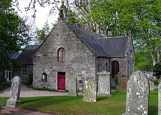
Cookney Parish Church, now business premises within a converted listed building, was a Christian place of worship in the village of Cookney, Aberdeenshire, Scotland.

The Elsick Mounth is an ancient trackway crossing the Grampian Mountains in the vicinity of Netherley, Scotland. This trackway was one of the few means of traversing the Grampian Mounth area in prehistoric and medieval times. The highest pass of the route is attained within the Durris Forest. Notable historical structures in the vicinity are Maryculter House, Lairhillock Inn and Muchalls Castle. Most of the lands through which the Elsick Mounth passes are within the Durris Forest; while this forest would have been a mixed deciduous forest in ancient times, currently it is managed as a coniferous monoculture with extensive amounts of clearfelling and subsequent replanting.
Alexander Silver was a wealthy East India Company trader, who lived in Netherley, Aberdeenshire, Scotland in the late 18th century; he and his son George Silver were noted agricultural innovators of their era. Alexander
The B9077 road is a public highway in Aberdeenshire, Scotland that connects the city of Aberdeen to the southern part of Banchory. The road crosses River Dee on the King George VI Bridge in Aberdeen. Outside the city the road has two traffic lanes and runs along the south bank of the River Dee, and in many places provides good views of the river. The road provides access to several historic and prehistoric features in south Deeside including Balbridie, Bucharn and Maryculter House. The highway numbering has been changed since 1985. Other historic features in the general vicinity are Crathes Castle, Milton of Crathes, and Netherley House.

Balfour, Aberdeenshire is a settlement on Royal Deeside in Aberdeenshire, Scotland. Balfour lies south of the River Dee.

Sindphana is a minor tributary of Godavari river that originates around the Chincholi hill in Patoda Taluka, Beed District, Maharashtra, in India. Crossing west to east its drainage basin covers nearly 80% of Beed District, making it the most important river within the district. The Majalgaon Dam, constructed across the river, irrigates 93885 hectares of land in Beed, Parbhani & Nanded districts.
