
The River Avon is a river in the Strathspey area of the Scottish Highlands, and a tributary of the River Spey. It drains the north-eastern area of the Cairngorm Mountains and is largely contained within the Cairngorms National Park
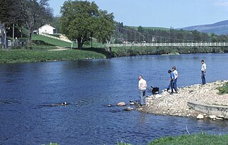
The River Spey is a river in the northeast of Scotland. At 98 mi (158 km) it is the ninth longest river in the United Kingdom, as well as the third longest and fastest-flowing river in Scotland. It is important for salmon fishing and whisky production.

Glenlivet is the glen in the Scottish Highlands through which the River Livet flows.

Strathspey is the region around the strath of the River Spey, Scotland, split between the Moray council area and the Badenoch and Strathspey committee area of Highland.
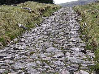
The Corrieyairack Pass is a 770 m (2526 ft) high pass in the Scottish Highlands at grid reference NN417986. It is notable for the presence of one of General Wade's military roads, built at the time of the Jacobite risings in the eighteenth century.
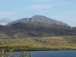
Ben Hope is a mountain in northern Scotland. It is the most northerly Munro, standing alone in the Flow Country south-east of Loch Hope in Sutherland. The mountain is a roughly triangular wedge, with a great crag on the west, with two lower shoulders to the south and northeast. Alpine flowers are abundant in season, although the ground is very rocky.

The Allt Graad or River Glass is a river in Easter Ross, Highland, Scotland. It is named on Ordnance Survey maps variously as Allt Graad and River Glass. It has also been known as the "Allt Grande", and the archaic Anglicization, "Aultgraad".

Slioch is a mountain in the Scottish Highlands situated in Wester Ross, eight kilometres north of the village of Kinlochewe. Slioch reaches a height of 981 metres (3218 feet) and towers above the south east end of Loch Maree to give one of the best known and most photographed sights in the Highlands. VisitScotland, the Scottish national tourist agency, has used video footage of Slioch in its television advertisements.

Aberchalder is a small settlement and estate at the northern end of Loch Oich in the Scottish Highlands and is in the Highland council area of Scotland. It lies on the A82 road and is situated in two parishes, Boleskine and Kilmonivaig. Fort Augustus is within 5 mi (8.0 km).

The River Truim is a right bank tributary of the River Spey in the Scottish Highlands. Its headwaters meet to the north of the Pass of Drumochter and flow northwards as the Truim past the dam at the northern end of Loch Ericht and through the village of Dalwhinnie, highest village in the Scottish Highlands. The distillery at Dalwhinnie producing Dalwhinnie Single Malt is also the highest in Scotland. The waters of its most significant tributary, the Allt Cuaich, are diverted in part along an aqueduct to Loch Ericht. The river continues north-northeastwards down Glen Truim, over the Falls of Truim and on to meet the Spey 2.5 miles (4 km) southwest of Newtonmore. It is closely followed for almost its entire length by both the A9 road and the mainline railway from Perth to Inverness.

Plodda Falls is a waterfall, situated 5 km south-west of the village of Tomich, near Glen Affric, in the Highlands of Scotland. The falls are 46 m high, and are on the Allt na Bodachan, near where it flows into the Abhainn Deabhag, which in turn joins with the River Affric to form the River Glass.

The River Garry is a major tributary of the River Tummel, itself a tributary of the River Tay, in the traditional county of Perthshire in the Scottish Highlands. It emerges from the northeastern end of Loch Garry (56.8193°N 4.2311°W), just to the southeast of the Pass of Drumochter, and flows southeastwards and eastwards down Glen Garry to the narrow Pass of Killiecrankie beyond which it joins the Tummel (56.7182°N 3.7790°W).

The River Fiddich is a right bank tributary of the River Spey in northeast Scotland. It rises on the eastern slopes of Corriehabbie Hill in Glenfiddich Forest and flows northeastwards beneath the A941 road, past Auchindoun Castle to a sharp bend adjacent to the A920 road where it turns westwards to flow to Dufftown. The Fiddich is joined on the eastern edge of the town by the Dullan Water which drains Glen Rinnes. Their combined waters then flow generally northwestwards, passing beneath the B9014 road near Balvenie Castle and then the A95 at Craigellachie immediately before meeting the Spey.

The River Dulnain is a major left bank tributary of the River Spey in northeast Scotland. It rises in the eastern part of the Monadhliath Mountains and flows in a generally northeastward direction through uninhabited country to Sluggan, where it is crossed by Sluggan Bridge, constructed by General Wade to carry a military road. Turning more easterly, the Dulnain passes beneath the modern A9 road which bypasses Carrbridge, the mainline railway and, in Carrbridge itself, the Carrbridge Packhorse Bridge that gives the village its name and the bridge carrying the B9153 road. The final section flowing east-northeast to the village of Dulnain Bridge is accompanied by the A938 road. The river empties into the Spey after passing beneath the A95 road and the disused bridge of the former Strathspey railway.
The River Nethy is a right bank tributary of the River Spey in northeast Scotland. It rises as the Garbh Allt between Cairn Gorm and A' Chòinneach on the northern slopes of the Cairngorms and flows northwards through Strath Nethy and into Abernethy Forest. Passing through Nethy Bridge where the B970 road crosses the river and gives its name to the village, the Nethy turns northwestward before entering the Spey at Broomhill. Numerous burns feed the Nethy, the most significant of which is the Dorback Burn which enters from its right bank a mile above Nethy Bridge.

The River Feshie is a major right bank tributary of the River Spey in north-east Scotland. It rises in the remote countryside of the Glenfeshie Forest, flowing initially eastwards before turning sharply to the northwest as a result of the capture of the waters of Geldie Burn. After gaining the waters of the River Eidart on its right bank and dropping down into Glen Feshie, it flows northwards through the wooded glen and is often braided in nature. It is joined by several burns which descend steeply from the Cairngorm plateau to the east and, on its left bank, by the Allt Chomhraig near Balachroick. The river passes beneath the B970 road at Feshiebridge and after a further 1.5 miles (2.5 km) it joins the Spey near the village of Kincraig.

The River Tromie is a right bank tributary of the River Spey in northeast Scotland. It emerges from the northern end of Loch an t-Seilich within the Gaick Forest and flows northwards, then northwestwards down through Glen Tromie to Bhran Cottage where it turns to the north-northeast. It is bridged by the B970 road at Tromie Bridge near Drumguish and flows a further 1.25 miles (2 km) northwest to meet the Spey near Lynchat.

The River Nairn is a 35 mile long river in the Scottish Highlands.

Dùn dà Làmh is a Pictish now ruined hill fort near Laggan in the Scottish Highlands. It became a scheduled monument in 1986, with an extension to the protected area realized in 2001.

The Lairig an Laoigh is a mountain pass through the Highlands of Scotland. In speech and sometimes in writing the name is reduced to "Lairig Laoigh". It is of glacial origin, dissecting the Cairngorm plateau, and it runs roughly north–south from Speyside to Deeside at one time being used as a drove road. Between the public road in the Abernethy Forest and the one at Linn of Dee the trekking distance is 31 kilometres (19 mi).
