Related Research Articles
Firth is a word in the English and Scots languages used to denote various coastal waters in the United Kingdom, predominantly within Scotland. In the Northern Isles, it more often refers to a smaller inlet. It is linguistically cognate to fjord, which has a more constrained sense in English. Bodies of water named "firths" tend to be more common on the Scottish east coast, or in the southwest of the country, although the Firth of Clyde is an exception to this. The Highland coast contains numerous estuaries, straits, and inlets of a similar kind, but not called "firth" ; instead, these are often called sea lochs. Before about 1850, the spelling "Frith" was more common.
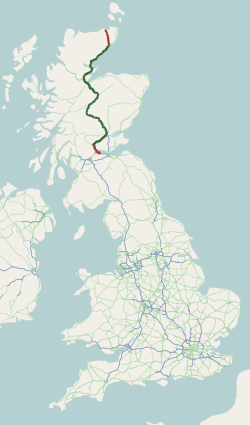
The A9 is a major road in Scotland running from the Falkirk council area in central Scotland to Scrabster Harbour, Thurso in the far north, via Stirling, Bridge of Allan, Perth and Inverness. At 273 mi (439 km), it is the longest road in Scotland and the fifth-longest A-road in the United Kingdom. Historically it was the main road between Edinburgh and John o' Groats, and has been called the spine of Scotland. It is one of the three major north–south trunk routes linking the Central Belt to the Highlands - the others being the A82 and the A90.

Thurso is a town and former burgh on the north coast of the Highland council area of Scotland. Situated in the historical County of Caithness, it is the northernmost town on the island of Great Britain. From a latitudinal standpoint, Thurso is located further north than the southernmost point of Norway and in addition lies more than 500 miles (800 km) north of London.

Halkirk is a village on the River Thurso in Caithness, in the Highland council area of Scotland. From Halkirk the B874 road runs towards Thurso in the north and towards Georgemas in the east. The village is within the parish of Halkirk, and is said by locals to be Scotland's first planned village.

Caithness is a historic county, registration county and lieutenancy area of Scotland.

Dunnet Head is a peninsula in Caithness, on the north coast of Scotland. Dunnet Head includes the most northerly point of both mainland Scotland and the island of Great Britain.
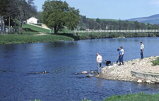
The River Spey is a river in the northeast of Scotland. At 98 mi (158 km) it is the eighth longest river in the United Kingdom, as well as the second longest and fastest-flowing river in Scotland. It is important for salmon fishing and whisky production.

Wick River, known also as River Wick, is a river in Caithness in Highland, Scotland. It has its source at the confluence of Scouthal Burn and Strath Burn near Achingale Mill at the northern end of Bardarclay Moss in the Flow Country. The river estuary, is in the North Sea bay of Wick and is straddled by the town of Wick. The source is at a height of about 25 metres, about 11 kilometres west and 2 kilometres north of the estuary.
Achairn Burn, known also as Haster Burn, is one of the major tributaries of Wick River, in Caithness, in the Highland area of Scotland. The burn's source is in headwaters flowing from the northern slope of the Hill of Toftgunn, which rises to over 170 metres, and in Camster Loch, which is at nearly 120 metres, between the Hill of Toftgunn and Ballharn Hill. The same area feeds also another major tributary of Wick River, the Camster/Rowans-Strath Burn. Achairn Burn enters Wick River at Mary Ford, about 10 kilometres to the northeast of the burn's source. Its entire course is within Caithness, as is the whole of the catchment basin of Wick River.

The River Thurso has Loch Rumsdale in Caithness as its source, about 26 kilometres south and 14 kilometres west of the burgh of Thurso, Caithness, and about 2 kilometres south of the railway line linking the burghs of Thurso and Wick with Inverness. At its source and until it reaches Loch More the river is known also as Strathmore Water. Caithness is in the Highland area of Scotland.
Dunnet is a village in Caithness, in the Highland area of Scotland. It is within the Parish of Dunnet.

Burnside is a predominantly residential area of Thurso, Caithness, in the Highland council area of Scotland.
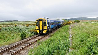
The Far North Line is a rural railway line entirely within the Highland area of Scotland, extending from Inverness to Thurso and Wick. As the name suggests, it is the northernmost railway in the United Kingdom. The line is entirely single-track, with only passing loops at some intermediate stations allowing trains to pass each other. In common with other railway lines in the Highlands and northern Lowlands, it is not electrified and all trains are diesel-powered.

The River Shin is a river in the Scottish North West Highlands.

The River Garry in Inverness-shire is a Scottish river punctuated by two long Lochs, in the region of Lochaber. It flows broadly west to east through Glen Garry, starting in a wilderness to the east of Knoydart and ending at Loch Oich in the Great Glen, which forms part of the Caledonian Canal. There are a few tiny settlements within Glen Garry, but the only village of any size near to the river is Invergarry, at its mouth. Loch Quoich at the western end of the watercourse is dammed by the largest mass earth fill dam in Scotland, and supplies water to Quoich hydroelectric power station. Loch Garry is dammed by a much smaller dam in the gorge where the river begins its descent to Invergarry, and supplies water to Invergarry hydroelectric power station, close to the mouth of the river. Both hydroelectric schemes were built in the 1950s, with the aim of stimulating economic regeneration in the area. They have altered the ecology of the river, as both lochs were made considerably bigger as a result of constructing the dams.
Crosskirk is a small remote hamlet, overlooking Crosskirk Bay, in Caithness, Scottish Highlands and is in the Scottish council area of Highland.
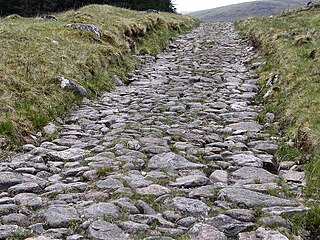
A network of military roads, sometimes called General Wade's Military Roads, was constructed in the Scottish Highlands during the middle part of the 18th century as part of an attempt by the British Government to bring order to a part of the country which had risen up in the Jacobite rebellion of 1715.

The Luggie Water is one of two streams which flow out of Cumbernauld. The Scottish New Town’s name derives from the Gaelic for "the meeting of the waters", which possibly refers to the Luggie Water and the Red Burn, both of which run through Cumbernauld but which never meet.

Loch Shurrery is a small, shallow, lowland freshwater loch lying approximately 8 mi (13 km) south west of Thurso in the Scottish Highlands. The loch has a somewhat elliptical shape with a perimeter of 7.4 km (4.6 mi). It is approximately 1.25 mi (2.01 km) long, has an average depth of 4.5 ft (1.4 m) and is 7 ft (2.1 m) at its deepest. The loch was surveyed on 6 October 1902 by John Parsons and T.R.H. Garrett and later charted as part of Sir John Murray's Bathymetrical Survey of Fresh-Water Lochs of Scotland 1897-1909. A dam lies to the north end of the loch.
References
- ↑ Ordnance Survey: Landranger map sheet 12 Thurso & Wick (John O’Groats) (Map). Ordnance Survey. 2014. ISBN 9780319226124.