Related Research Articles

Kincardineshire, also known as the Mearns, is a historic county, registration county and lieutenancy area on the coast of northeast Scotland. It is bounded by Aberdeenshire on the north and west, and by Angus on the south.

Findon or Finnan is a fishing village eight miles south of Aberdeen, famous for originating the smoked haddock known as Finnan haddie. The Findon moor has a number of paths through it, many of which run along the cliffs. Deer can often be seen there. Nearby features include the Portlethen Moss Nature Reserve.

Newtonhill is a commuter town in Kincardineshire, Scotland. It is popular due to its location, just six miles south of Aberdeen with easy reach of Stonehaven and with views over the North Sea.

Portlethen Village is a settlement along the North Sea coast in Aberdeenshire, Scotland. The village is also known as Old Portlethen. The skerry of Craigmaroinn is situated just off the coastline near Portlethen Village.

Muchalls is a small coastal ex-fishing village in Kincardineshire, Scotland, south of Newtonhill and north of Stonehaven. Muchalls is situated slightly north of a smaller hamlet known as the Bridge of Muchalls. At the western edge of Muchalls is the historic Saint Ternan's Church. The rugged North Sea coastline near Muchalls features numerous cliffs, sea stacks and headlands, not infrequently in haar. The Grim Brigs headland is situated at Muchalls southern edge and Doonie Point headland is approximately 1.5 kilometres south.
The Burn of Pheppie is an easterly flowing coastal stream in Aberdeenshire, Scotland that discharges to the North Sea immediately north of the village of Muchalls. Draining chiefly agricultural lands, this stream has a notable lack of turbidity and a pH level of approximately 8.02. Armouring of the stream bottom consists of pebbles, many of which are quartzite in composition, leading to a golden-green effect in some locations. Other nearby watercourses discharging to the North Sea include Burn of Elsick to the north and Burn of Muchalls to the south.
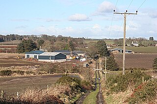
The Causey Mounth is an ancient drovers' road over the coastal fringe of the Grampian Mountains in Aberdeenshire, Scotland. This route was developed as the main highway between Stonehaven and Aberdeen around the 12th century AD and it continued to function as the principal route connecting these two cities until the mid 20th century, when modern highway construction of the A90 road occurred in this area. There are extant paved and usable sections of this road over part of the alignment; however, many parts of the ancient route are no more than footpaths, and in some cases the road has vanished into agricultural fields. Constructed in the Middle Ages, the Causey Mounth was created as an elevated rock causeway to span many of the boggy areas such as the Portlethen Moss. A considerable portion of the alignment of the Causey Mounth is illustrated on the UK Ordnance Survey Map, although a large fraction of the route cannot be navigated by a conventional passenger vehicle.

Elsick House is a historic house in Kincardineshire, northeast Scotland.
Cammachmore is a hamlet in the coastal region near the North Sea in Aberdeenshire. It lies slightly west of the A92 road and the ancient Causey Mounth passes through the community. Historic Elsick House is situated due west of Cammachmore. Other nearby historic features include Gillybrands, Saint Ternan's Church, Muchalls Castle and the Lairhillock Inn.
Cowie Castle is a ruined fortress in Aberdeenshire, Scotland. The site lies at the northern end of Stonehaven on the North Sea coast. To the immediate south is the Cowie Bridge crossing of the Cowie Water. Evidence of prehistoric man exists in the vicinity dating to the Iron Age in the form of ring cairns.
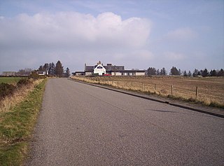
Cookney is a hamlet in Aberdeenshire, Scotland in proximity to Netherley in the Mounth of the Grampian Highlands. The community is situated on a hilltop approximately 5 miles (8 km) northwest of Stonehaven, about 3 miles (5 km) northwest of the Bridge of Muchalls, and about 2 miles (3 km) west of Muchalls Castle. From Cookney a portion of the ancient route of the Causey Mounth is visible to the east near Whinward Farm, although the track is not truly recognizable from that distance. The Cookney Church is a prominent historic landmark of Cookney.

Banchory-Devenick is a village approximately two kilometres south of the city of Aberdeen, Scotland in the Lower Deeside area of Aberdeenshire. The village should not be confused with the historic civil parish of the same name which spanned the River Dee until 1891, its northern part lying in Aberdeenshire and its southern part in Kincardineshire. In that year the northern part became part of the neighbouring parish of Peterculter, the southern part remaining as the parish of Banchory-Devenick. The village of Banchory-Devenick is on the B9077 road, and the ancient Causey Mounth passes directly through the village. An historic graveyard dating to 1157 AD is present at the village of Banchory-Devenick. Other historic features in the vicinity include Saint Ternan's Church, Muchalls Castle and the Lairhillock Inn.

Saint Ternan's Church is an Episcopal church in the Diocese of Brechin, near Muchalls in Aberdeenshire, Scotland.

The Chapel of St. Mary and St. Nathalan is a ruined chapel overlooking the North Sea immediately north of Stonehaven, in the Mearns of Scotland, along the northern shoreline of Stonehaven Bay. The founding of this Christian place of worship is associated with St. Nathalan. who lived circa 650 AD. The structure is alternatively known as Cowie Chapel. The chapel is at the point where the Highland Boundary Fault meets the sea and so is on the dividing line between the highlands and lowlands of Scotland.
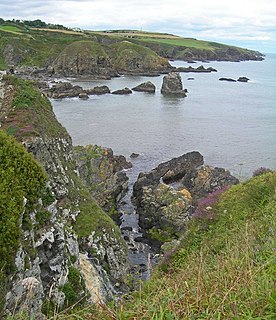
Doonie Point is a rocky headland situated approximately 1.5 kilometres south of the village of Muchalls in Aberdeenshire, Scotland. The clifftop of Doonie Point yields views to the north of Grim Brigs, Brown Jewel and the coast of Newtonhill. To the south are views of the Castle Rock of Muchalls and the rugged North Sea coastline toward Stonehaven. Notable historic structures in the vicinity of Doonie Point are the Chapel of St. Mary and St. Nathalan, Muchalls Castle and the Mill of Muchalls. This site is a recognised rock climbing venue. Doonie Point is catalogued within the marine rescue activities for this part of the coast of northeast Scotland.
Grim Brigs is a rocky headland on the North Sea at Muchalls, Scotland. Notable historic features in this vicinity include St. Ternan's Church, Muchalls Castle and Elsick House. Approximately one kilometre inland is the noted medieval drovers' road known as the Causey Mounth. The geology of Grim Brigs is associated with the harder rock formations north of the Highland Boundary Fault, which forms the boundary between the Scottish Highlands and Lowlands. This Highland Boundary Fault emerges at the North Sea approximately four kilometres south of Grim Brigs near the Chapel of St. Mary and St. Nathalan.
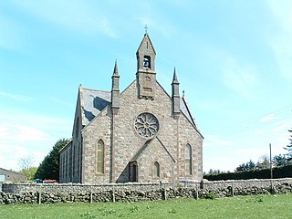
Cookney Parish Church, now business premises within a converted listed building, was a Christian place of worship in the village of Cookney, Aberdeenshire, Scotland.
May Craig is a rocky island situated along the North Sea coast of Aberdeenshire, Scotland. May Craig lies about one half mile south of Newtonhill and a mile northeast of the village of Muchalls. A small islet of the same name lies three miles to the north-northeast.
Craigmaroinn is a skerry in the North Sea near the Aberdeenshire coastline in Scotland. Craigmaroinn is situated midway between the coastal villages of Portlethen Village and Downies. Historical points of interest in the local area are Elsick House, Gillybrands and Muchalls Castle.
The Brown Jewel is a sea stack on the North Sea coast of Scotland, north of the village of Muchalls in Aberdeenshire.
References
- ↑ United Kingdom Ordnance Survey Map Landranger 45, Stonehaven and Banchory, 1:50,000 scale, 2004
- 1 2 3 C.Michael Hogan, Causey Mounth, Megalithic Portal, ed. by A Burnham, Nov 3, 2007
- ↑ Archibald Watt, Highways and Byways around Kincardineshire, Stonehaven Heritage Society (1985)
- ↑ Brian H. Watt, Old Newtonhill and Muchalls, Stenlake Publishing, Glasgow (2005)
| | This Aberdeenshire location article is a stub. You can help Wikipedia by expanding it. |