Portlethen Moss

Last updated

The Portlethen Moss 57°03′27″N02°08′51″W / 57.05750°N 2.14750°W / 57.05750; -2.14750 is an acidic bog nature reserve located to the west of the town of Portlethen, Aberdeenshire in Scotland. Like other mosses, this wetland area supports a variety of plant and animal species, even though it has been subject to certain development and agricultural degradation pressures. For example, the Great Crested Newt was found here prior to the expansion of the town of Portlethen. Many acid-loving vegetative species occur in Portlethen Moss, and the habitat is monitored by the Scottish Wildlife Trust.

Contents

Portlethen Moss is the location of considerable prehistoric, Middle Ages and seventeenth century history, largely due to a ridge near the bog which was the route of early travellers. By at least the Middle Ages, this trackway was more formally constructed with raised stonework and called the Causey Mounth. Without this drovers' road, travel through the Portlethen Moss and several nearby bogs would have been impossible between Aberdeen and coastal points to the south.

History

True heather, a common plant on the Portlethen Moss Calluna vulgaris 1.jpg
True heather, a common plant on the Portlethen Moss

Prehistoric man inhabited the Portlethen Moss area as evidenced by well-preserved Iron Age stone circles and other excavated artifacts nearby. [1] Only the outcrops and ridge areas would have been habitable, but the desirability of primitive habitation would have been enhanced by proximity to the sea and natural defensive protection of the moss to impede intruders. From Tacitus accounts [2] of the Roman general Agricola, it is known that the Romans were daunted by Portlethen Moss, Netherley Red Moss, Cookney Moss and other local bogs that hindered travel. This is also evidenced by the Roman Camp of Raedykes having been established immediately south of this cluster of mosses; the Romans, not being able to progress further north, turned inland toward Netherley. The Portlethen Moss is near the Grampian Mountains.

The ancient Causey Mounth passage specifically connected the Bridge of Dee to the town of Stonehaven. This route was used to access the historic meeting of the Covenanters at Muchalls Castle in the year 1638 AD as they opposed the Bishops of Aberdeen. The route was also that taken by William Keith, 7th Earl Marischal and James Graham, 1st Marquess of Montrose when they led a Covenanter army of 9000 men in the biggest battle of the Bishops' Wars in 1639 [3]

Further to the east of Portlethen Moss lie three original coastal fishing villages: Findon, Portlethen Village and Downies. In the period from 1960 to 2005, Portlethen has developed as a dormitory town to Aberdeen and a location for retail superstores.

Conservation status

The Portlethen Moss is a recognised nature preserve by the Scottish Wildlife Trust (with designation PLM076) and the Aberdeenshire Council. While peat cutting was conducted in prehistoric and Middle Ages times, there has been no harvesting of peat in the modern era. There is some ongoing loss of moss habitat from cattle grazing, but the most significant threat is from ongoing land development pressure; [4] in fact, half of the Portlethen Moss has been lost to urban (low-density) land development by the town of Portlethen during the period 1985 to 2005. Trampling is considered an insignificant threat due to the small animal or human presence in the existing nature reserve area; furthermore, cattle grazing, while ongoing, is deemed a much lesser current threat than population expansion pressure. Enrichment (addition of grazing animal manure) is not a major issue due to the low density of animals. As a net result, damage to the primordial moss is considered extensive and widespread by the Scottish Wildlife Trust. The raised bog habitat of the Portlethen Moss is also protected by the United Kingdom Biodiversity Action Plan.

Topography and meteorology

Ruined Episcopal chapel from 18th century south of the Portlethen Moss along the Causey Mounth Ruinedchapel.jpg
Ruined Episcopal chapel from 18th century south of the Portlethen Moss along the Causey Mounth

Portlethen Moss is considered a raised bog, because its general situation is on higher ground, at the edge of the Mounth, a coastal mountain spur of the Grampian Mountains overlooking the North Sea. There are rock outcrops and strewn boulders relict from the glacial age at this site. Elevations within the Portlethen Moss range from approximately 35 to 60 metres above sea level. Formation of this moss has occurred due to extensive sets of depressions in the underlying rock formations of Old Red Sandstone. The entire water composition of the bog thus has been provided by precipitation with no source of surface runoff, since the topography reduces to lower elevations in every direction. Due to the high winds, moderate precipitation and cool temperatures that generally prevail, conditions are favourable for the formation of an acid bog, since water stagnates, but eventually evaporates with ensuing acidity enhancement of decaying organic matter. There was virtually no drainage outlet in prehistoric times, and little drainage even in modern times.

Evolution of Portlethen Moss

Many coastal mosses were initiated by the process of glaciation, which sheared rock formations to a generally level terrain, while also gouging moderate-sized craters that would pond. This description fits the fundamental situation of Portlethen Moss, where sphagnum would have flourished over millennia of evaporation, further intensifying the soil acidity, fueled by organic matter decaying, with little drainage outlet. A layer of sphagnum moss would have developed at the benthic level of the bog, and additional sphagnum layers floated in mats atop the bog.

At an intermediate level of evolution, thick peat layers formed from the decay and carbonisation of the rotting sphagnum. Generations of Carex and Juncus flourished, leading to further decay of these materials and eventual heightening of the organic mass. Finally, secondary vegetation took root in the spongy sphagnum mats, adding greater biomass to the bog. In some cases, the heavily saturated organic layers could rupture, spilling large volumes of mud and organic debris into surrounding fields, thus enabling a bed for further spatial expansion of the entire bog. Ultimately, the colour of the moss waters became blood red from the successive organic decay and stagnation. Only in times associated with cattle grazing and significant human presence (probably the late Iron Age) would this process reverse and the bog reduce in size.

Vegetation

A wide variety of sphagnum, sedges, rushes and other characteristic bog species inhabit Portlethen Moss. Sometimes, insectivorous plants reside in mosses, since the soils are generally nutrient-poor. The heath also serves as a food source for the area roe deer, while Corydalis claviculata is an attractive host for numerous butterfly larvae. Representative plant species found in this nature reserve include:

Erica tetralix, a wildflower found on the Portlethen Moss Erica tetralix 2B.jpg
Erica tetralix , a wildflower found on the Portlethen Moss
Insectivorous sundew plants are found at Portlethen Moss Drosera-rotundifolia.jpg
Insectivorous sundew plants are found at Portlethen Moss

Relation to other mosses

There are numerous mosses or bog habitats in Scotland, many of them situated also in Aberdeenshire, including the Cookney Moss, Leuchar Moss and Red Moss of Netherley nearby. Many other shires within Scotland that contain mosses such as Fife, Angus, Morayshire and Lanarkshire. Some of these are lowland bogs and others, like Portlethen Moss, are raised bogs. There are other similar acidic peat bogs in the northern part of North America, Russia and northern Europe, but in those locations, they are usually called "bogs".

See also

Related Research Articles

<span class="mw-page-title-main">Bog</span> Type of wetland with peat-rich soil

A bog or bogland is a wetland that accumulates peat as a deposit of dead plant materials – often mosses, typically sphagnum moss. It is one of the four main types of wetlands. Other names for bogs include mire, mosses, quagmire, and muskeg; alkaline mires are called fens. A bayhead is another type of bog found in the forest of the Gulf Coast states in the United States. They are often covered in heath or heather shrubs rooted in the sphagnum moss and peat. The gradual accumulation of decayed plant material in a bog functions as a carbon sink.

<span class="mw-page-title-main">Askham Bog</span> Protected site and nature reserve in York, England

Askham Bog is small area of peat bog and Site of Special Scientific Interest situated within the Vale of York in North Yorkshire, England. It lies to the south-west of York, north of Copmanthorpe and near Askham Richard and Askham Bryan. It is regarded as one of the most ecologically diverse sites in Northern England.

<i>Sphagnum</i> Genus of mosses, peat moss

Sphagnum is a genus of approximately 380 accepted species of mosses, commonly known as sphagnum moss, also bog moss and quacker moss. Accumulations of Sphagnum can store water, since both living and dead plants can hold large quantities of water inside their cells; plants may hold 16 to 26 times as much water as their dry weight, depending on the species. The empty cells help retain water in drier conditions.

<span class="mw-page-title-main">Mer Bleue Bog</span> National park in Ontario,canada

Mer Bleue Bog is a 33.43 km2 (12.91 sq mi) protected area in Gloucester, Ontario, an eastern suburb of Ottawa in Eastern Ontario, Canada. Its main feature is a sphagnum bog that is situated in an ancient channel of the Ottawa River and is a remarkable boreal-like ecosystem normally not found this far south. Stunted black spruce, tamarack, bog rosemary, blueberry, and cottongrass are some of the unusual species that have adapted to the acidic waters of the bog.

<span class="mw-page-title-main">Findon, Aberdeenshire</span> Fishing village eight miles south of Aberdeen, Scotland

Findon or Finnan is a fishing village eight miles south of Aberdeen, famous for originating the smoked haddock known as Finnan haddie. The Findon moor has a number of paths through it, many of which run along the cliffs. Deer can often be seen there. Nearby features include the Portlethen Moss Nature Reserve.

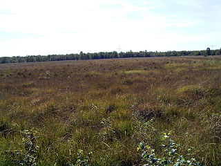
Red Moss is a wetland bog in Aberdeenshire, Scotland, located at the northwestern edge of the village of Netherley. The moss is designated a national Site of Special Scientific Interest by Scottish Natural Heritage, due to its biodiversity and undisturbed character. The elevation of Red Moss is 113 metres above mean sea level. The upland areas above Red Moss are characterised as agricultural and woodland parcels which are generally attractive and separated by ancient drystone walls or hedgerows.

<span class="mw-page-title-main">Netherley, Aberdeenshire</span>

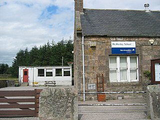
Netherley, Scotland is a village in Aberdeenshire, situated approximately five miles northwest of Stonehaven. Netherley is located in the Mounth area of the Grampian Highlands. At the eastern edge of Netherley is a significant wetland bog known as Red Moss. To the southwest of Netherley lie Meikle Carewe Hill and Curlethney Hill. At the south edge of Netherley is the peak of Craggie Cat.

The Burn of Elsick is a coastal stream in Aberdeenshire, Scotland that discharges to the North Sea. This watercourse drains primarily agricultural lands and enters the North Sea at Newtonhill.

<span class="mw-page-title-main">Causey Mounth</span> Ancient drovers road in Aberdeenshire, Scotland

The Causey Mounth is an ancient drovers' road over the coastal fringe of the Grampian Mountains in Aberdeenshire, Scotland. This route was developed as the main highway between Stonehaven and Aberdeen around the 12th century AD and it continued to function as the principal route connecting these two cities until the mid 20th century, when modern highway construction of the A90 road occurred in this area. There are extant paved and usable sections of this road over part of the alignment; however, many parts of the ancient route are no more than footpaths, and in some cases the road has vanished into agricultural fields. Constructed in the Middle Ages, the Causey Mounth was created as an elevated rock causeway to span many of the boggy areas such as the Portlethen Moss. A considerable portion of the alignment of the Causey Mounth is illustrated on the UK Ordnance Survey Map, although a large fraction of the route cannot be navigated by a conventional passenger vehicle.

<span class="mw-page-title-main">Cookney</span>

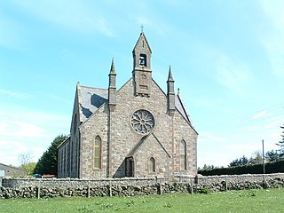
Cookney is a hamlet in Aberdeenshire, Scotland in proximity to Netherley in the Mounth of the Grampian Highlands. The community is situated on a hilltop approximately 5 miles (8 km) northwest of Stonehaven, about 3 miles (5 km) northwest of the Bridge of Muchalls, and about 2 miles (3 km) west of Muchalls Castle. From Cookney a portion of the ancient route of the Causey Mounth is visible to the east near Whinward Farm, although the track is not truly recognizable from that distance. The Cookney Church is a prominent historic landmark of Cookney.

<span class="mw-page-title-main">Cors Caron</span> Raised bog in Ceredigion, Wales

Cors Caron is a raised bog in Ceredigion, Wales. Cors is the Welsh word for "bog". Cors Caron covers an area of approximately 349 hectares. Cors Caron represents the most intact surviving example of a raised bog landscape in the United Kingdom. About 44 different species groups inhabit the area including various land and aquatic plants, fish, insects, crustaceans, lichen, fungi, terrestrial mammals and birds.

<span class="mw-page-title-main">Doonie Point</span> Location in Scotland

Doonie Point is a rocky headland situated approximately 1.5 kilometres south of the village of Muchalls in Aberdeenshire, Scotland. The clifftop of Doonie Point yields views to the north of Grim Brigs, Brown Jewel and the coast of Newtonhill. To the south are views of the Castle Rock of Muchalls and the rugged North Sea coastline toward Stonehaven. Notable historic structures in the vicinity of Doonie Point are the Chapel of St. Mary and St. Nathalan, Muchalls Castle and the Mill of Muchalls. This site is a recognised rock climbing venue. Doonie Point is catalogued within the marine rescue activities for this part of the coast of northeast Scotland.

<span class="mw-page-title-main">Elsick Mounth</span>

The Elsick Mounth is an ancient trackway crossing the Grampian Mountains in the vicinity of Netherley, Scotland. This trackway was one of the few means of traversing the Grampian Mounth area in prehistoric and medieval times. The highest pass of the route is attained within the Durris Forest. Notable historical structures in the vicinity are Maryculter House, Lairhillock Inn and Muchalls Castle. Most of the lands through which the Elsick Mounth passes are within the Durris Forest; while this forest would have been a mixed deciduous forest in ancient times, currently it is managed as a coniferous monoculture with extensive amounts of clearfelling and subsequent replanting.

<i>Aulacomnium palustre</i> Species of moss

Aulacomnium palustre, the bog groove-moss or ribbed bog moss, is a moss that is nearly cosmopolitan in distribution. It occurs in North America, Hispaniola, Venezuela, Eurasia, and New Zealand. In North America, it occurs across southern arctic, subboreal, and boreal regions from Alaska and British Columbia to Greenland and Quebec. Documentation of ribbed bog moss's distribution in the contiguous United States is probably incomplete. It is reported sporadically south to Washington, Wyoming, Georgia, and Virginia.

<span class="mw-page-title-main">Purple moor grass and rush pastures</span> One of UKs natural habitats

Purple moor grass and rush pastures is a type of Biodiversity Action Plan habitat in the UK. It occurs on poorly drained neutral and acidic soils of the lowlands and upland fringe. It is found in the South West of England, especially in Devon.

<span class="mw-page-title-main">Chyenhal Moor</span> Site of Special Interest in Cornwall

Chyenhal Moor is a poorly drained shallow valley, 2 miles (3.2 km) to the south-west of Penzance, Cornwall. Due to several rare plants in a diverse range of habitats, it was notified as a Site of Special Scientific Interest (SSSI) in 1951.

<span class="mw-page-title-main">Bewick and Beanley Moors</span>

Bewick and Beanley Moors is the name given to a Site of Special Scientific Interest (SSSI) in north Northumberland, in the north-east of England. The moors are asserted to be of national importance by Natural England for the extent, quality and diversity of upland types including heaths, fens, wet grassland, flushes, mires and blanket bogs, together creating an extensive mosaic habitat supporting an exceptional community of amphibians. The moors are important, too, for their relict juniper woodland and scrub.

<span class="mw-page-title-main">Floating mat</span>

A floating mat is a layer of mosses and other, especially stoloniferous, plants that grows out from the shore across the surface of a lake or pond. This type of habitat is protected and is designated in the European Habitats Directive as "LRT No. 7140 Transition and Floating Mat Bogs".

<span class="mw-page-title-main">Moine Mhòr</span> Area of raised bog in Argyll and Bute, Scotland

Moine Mhòr encompasses a large area of raised bog in the Kilmartin Glen area of Argyll and Bute, Scotland. As well as raised bog there are areas of saltmarsh, brackish grassland, alder carr, fen and woodland, and the variety of habitats at Moine Mhòr provide important habitats for a variety of animal and plant species. The area was declared a national nature reserve (NNR) in 1987, and is now owned and managed by NatureScot. According to NatureScot lowland raised bogs like Moine Mhòr are some of the rarest and most threatened natural wildlife habitats in Europe, due to removal of peat, afforestation and reclamation of farmland.

References

  1. Duffy, A 1998 'Charcoal samples', in Rees, T 'Excavation of Cairnwell Ring-Cairn, Portlethen', Proc Soc Antiq Scot, 127, 255-280
  2. Tacitus, Accounts of Agricola in Caledonia, ca 42AD
  3. Archibald Watt, Highways and Biways around Kincardineshire , Stonehaven Heritage Society (1985)
  4. Fiona Everingham, Portlethen Moss Survey, Scottish Wildlife Trust, 1994