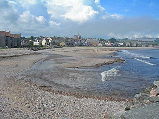
Stonehaven is a town in Aberdeenshire, Scotland. It lies on Scotland's northeast coast and had a population of 11,602 at the 2011 Census. After the demise of the town of Kincardine, which was gradually abandoned after the destruction of its royal castle in the Wars of Independence, the Scottish Parliament made Stonehaven the successor county town of Kincardineshire. Stonehaven had grown around an Iron Age fishing village, now the "Auld Toon", and expanded inland from the seaside. As late as the 16th century, old maps indicate the town was called Stonehyve,Stonehive, Pont also adding the alternative Duniness. It is known informally to locals as Stoney.

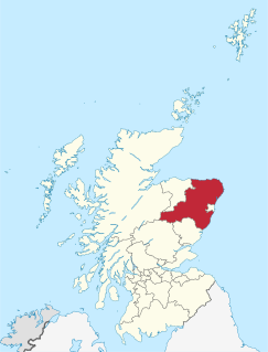
Kincardineshire, also known as the Mearns, is a historic county, registration county and lieutenancy area on the coast of northeast Scotland. It is bounded by Aberdeenshire on the north and west, and by Angus on the south.

Kincardine and Mearns is one of six area committees of the Aberdeenshire council area in Scotland. It has a population 38,506. There are significant natural features in this district including rivers, forests, mountains and bogs.

Johnshaven is a coastal village along the North Sea located in Aberdeenshire, Scotland. It is accessed off the A92 coast road that connects Fife and Stonehaven, where it joins the A90 and continues northward to Aberdeen and beyond. About two miles southwest of Johnshaven lies Milton Ness, which includes a red sandstone cliff landform.

Catterline is a coastal village on the North Sea in Aberdeenshire, Scotland. It is situated about 5 miles (8.0 km) south of Stonehaven; nearby to the north are Dunnottar Castle and Fowlsheugh Nature Reserve. Other noted architectural or historic features in the general area include Fetteresso Castle, Fiddes Castle, Chapel of St. Mary and St. Nathalan and Muchalls Castle.
The Stonehaven Tolbooth is a late 16th-century stone building originally used as a courthouse and a prison in the town of Stonehaven, Aberdeenshire, Scotland. Constructed of local Old Red Sandstone, the prison probably attained its greatest note, when three local Episcopalian clergymen were imprisoned for holding services for more than nine people. Lying midway along the old north quay of the Stonehaven Harbour, the present day Tolbooth serves as a history museum with a restaurant on the floor above the ground floor. It is a category A listed building.

Ury House is a large ruined mansion in Aberdeenshire, Scotland, built in the Elizabethan style in 1885 by Sir Alexander Baird, 1st Baronet. It is situated on the north-east coast about 1 mile (1.6 km) north of Stonehaven in the former county of Kincardineshire.
Carron Water is a river in Kincardineshire, Scotland.

The Cowie Water is a river rising in the Grampian Mountains in Aberdeenshire, Scotland that discharges to the North Sea in the northern part of Stonehaven. south of the ruined Cowie Castle. Tributaries of the Cowie Water include the Burn of Monboys, which drains the area to the north, in which the archaeological site Raedykes Roman Camp is situated; and Cowton Burn.
Crawton is a former fishing community on the southeast Aberdeenshire coast in Scotland, deserted since 1927.
The Fetteresso Forest is a woodland that is principally coniferous situated in the Mounth range of the Grampian Mountains in Aberdeenshire, Scotland. The forest has a number of prominent mountain peaks including the Hill of Blacklodge and Craiginour peak. A good overlook for viewing the forest from the north side lies on an unnamed tarmack road which leads north from the Slug Road to the Raedykes Roman site. The Cowie Water flows through and drains much of the forest. To the north of the easternmost part of the forest is the archaeological site Raedykes Roman Camp, as well as Cowton Burn. The Slug Road runs along much of the northeast perimeter of Fetteresso Forest.

The Kirktown of Fetteresso is a well-preserved village near Stonehaven, Scotland. In the planning area of Kincardine and Mearns, Aberdeenshire, this village contains many very old stone residential structures as well as the Church of St. Ciarans and its associated graveyard. The Carron Water winds through the Kirktown of Fetteresso, and Fetteresso Castle, a listed building, lies at the northwestern verge. Other notable area historic structures are the Ury House, Stonehaven Tolbooth, Muchalls Castle and the Chapel of St. Mary and St. Nathalan. Some of the earliest area prehistory has been found nearby on the Fetteresso Estate grounds, where there have been archaeological finds from the Bronze Age.

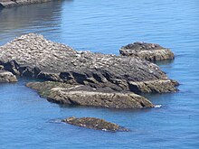
Bowdun Head is a headland landform on the North Sea coast approximately one kilometre south of Stonehaven, Scotland.(Ordnance Survey, 2004) Slightly to the north is another headland, Downie Point. Somewhat to the south along the coast is Dunnottar Castle on the far side of the bay of Castle Haven. Other historic structures in the general vicinity include the Stonehaven Tolbooth, Fetteresso Castle, the Chapel of St. Mary and St. Nathalan and Muchalls Castle. There is considerable prehistory associated with the local area including a Pictish hill fort on the sea stack of Dunnicaer immediately to the north, and Bronze Age archaeological sites at Fetteresso and Spurryhillock, both somewhat inland of Bowdun Head.

Downie Point is a prominent headland located at the southern edge of Stonehaven Bay in Aberdeenshire, Scotland. From the Stonehaven Harbour, there is a panoramic view of this cliff landform, especially from the tip of Bellman's Head.
Bellman's Head is a headland point comprising the northern boundary of Stonehaven Bay in Stonehaven, Scotland. The corresponding headland at the south of the bay is Downie Point. Notable historic features in the general vicinity include the Tolbooth, Fetteresso Castle and Muchalls Castle.
Red Cloak is an industrial area of Stonehaven, Aberdeenshire, Scotland. The site's settlement history is associated with events at the nearby Chapel of St. Mary and St. Nathalan. In current times Red Cloak is primarily an industrial dominated land use that includes Aberdeenshire Council recycling and refuse disposal functions. Earliest area prehistory is evidenced by Bronze Age finds at Fetteresso Castle and Ury House.
Thornyhive Bay is an embayment along the North Sea coast in Aberdeenshire, Scotland. This bay is situated approximately 2.5 miles south of the town of Stonehaven and approximately 2.5 miles north of the Fowlsheugh Nature Reserve. The steep cliffs afford sightings of certain seabirds.
Bogjurgan Hill is an elevated landform at the southern verge of the Fetteresso Forest in Aberdeenshire, Scotland. Its top is at an elevation of 299 metres (981 ft) above sea level. Historical features in this region of Kincardineshire include Fetteresso Castle, Drumtochty Castle and Muchalls Castle.
Stonehaven Bay is a natural harbour in Aberdeenshire, Scotland. The town of Stonehaven is built along the shore of Stonehaven Bay. Nearby historical features include Fetteresso Castle, Stonehaven Tolbooth, Dunottar Castle and Muchalls Castle.