Marykirk

Last updated
Marykirk High Street after floods, November 2009 Marykirk High Street after Floods.JPG
Marykirk High Street after floods, November 2009
Marykirk Church Marykirk Church.JPG
Marykirk Church
Marykirk ancient kirk and kirkyard Marykirk Old Kirk and Kirkyard.JPG
Marykirk ancient kirk and kirkyard

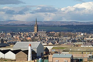
Marykirk (Scottish Gaelic : Obar Luathnait) is a village in the Kincardine and Mearns area of Aberdeenshire, Scotland, next to the border with Angus at the River North Esk.

Contents

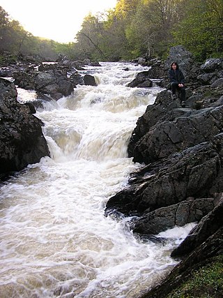
The village is approximately 6 miles ENE of Montrose at the southern end of the Howe of the Mearns. The road bridge carrying the A937 over the River North Esk is a substantial structure with four arches. It was designed by Robert Stevenson and completed in 1815 at the cost of £1,000 replacing the previous route to the village, an ancient ford. There is a rail bridge across the same river some 600 m north of the road bridge and the village once had a rail station to the north east.

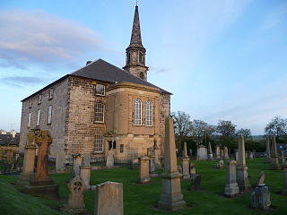
The present parish church was rebuilt in 1806 replacing the previous church, the remains of which can be found in the adjacent kirkyard. The older church was dedicated to St Mary and consecrated in 1242 by the Bishop de Bernham. The settlement and parish were called Aberluthnot before being renamed after the church. The village was made a burgh of barony in 1540 in favour of David Barclay of Mathers by Cardinal David Beaton in 1540, confirmed in 1543 by Queen Mary. [1] The centre of the village has an ancient market cross. The grand gates to the now demolished mansion Kirktonhill House, built in 1799 for the Taylor family, once the home of oil merchant R W Adamson, can be found still in position. [2] Once boasting many small businesses supporting the surrounding agricultural lands, including a part time post office and newsagents the village now has no shops and only the hotel. The nearest shop is a short drive to Montrose or Laurencekirk in the other direction.

The village also has a small primary school of three teachers with between 30 and 40 pupils. [3] as well as a hotel, the 19th-century coaching house, the Marykirk Hotel. [4]

A rare example of a morthouse is located in the churchyard, built to frustrate the activities of bodysnatchers in the 19th century. [5]

From 1996-2002, and then 2009-2019 the village has held an annual raft race in the River North Esk. It could not restart after some preventative work was done on the railway bridge, making it too dangerous for the raft race to proceed.

Marykirk was also the site of the world's first electricity-generating wind turbine, built by James Blyth in 1887 to light his summer residence in the village. [6]

Up until the end of July 2010, the village also had its own amateur weather station.

Notable people

Related Research Articles

<span class="mw-page-title-main">South Queensferry</span> Human settlement in Scotland

Queensferry, also called South Queensferry or simply "The Ferry", is a town to the west of Edinburgh, Scotland. Traditionally a royal burgh of West Lothian, it is now administered by the City of Edinburgh Council. It lies ten miles to the north-west of Edinburgh city centre, on the shore of the Firth of Forth between the Forth Bridge, Forth Road Bridge and the Queensferry Crossing. The prefix South serves to distinguish it from North Queensferry, on the opposite shore of the Forth. Both towns derive their name from the ferry service established by Queen Margaret in the 11th century, which continued to operate at the town until 1964, when the Road Bridge was opened.

<span class="mw-page-title-main">Montrose, Angus</span> Town and former Royal burgh in Scotland

Montrose is a town and former royal burgh in Angus, Scotland. Situated 28 miles north of Dundee and 37 miles south of Aberdeen, Montrose lies between the mouths of the North and South Esk rivers. It is the northernmost coastal town in Angus and developed as a natural harbour that traded in skins, hides, and cured salmon in medieval times.

<span class="mw-page-title-main">Kincardineshire</span> Historic county in Scotland

Kincardineshire, also known as the Mearns, is a historic county, registration county and lieutenancy area on the coast of northeast Scotland. It is bounded by Aberdeenshire on the north and west, and by Angus on the south.

<span class="mw-page-title-main">Musselburgh</span> Town in East Lothian, Scotland

Musselburgh is the largest settlement in East Lothian, Scotland, on the coast of the Firth of Forth, 5 miles (8 km) east of Edinburgh city centre. It has a population of 21,100.

<span class="mw-page-title-main">River Esk, Lothian</span> River in Midlothian and East Lothian, Scotland

The River Esk, also called the Lothian Esk, is a river that flows through Midlothian and East Lothian, Scotland.

<span class="mw-page-title-main">Inveresk</span> Conservation village in East Lothian, Scotland

Inveresk is a village in East Lothian, Scotland situated 58 mi (1 km) to the south of Musselburgh. It has been designated a conservation area since 1969. It is situated on slightly elevated ground on the north bank of a loop of the River Esk. This ridge of ground, 20 to 25 metres above sea level, was used by the Romans as the location for Inveresk Roman Fort in the 2nd century AD.

<span class="mw-page-title-main">Laurencekirk</span> Human settlement in Scotland

Laurencekirk, locally known as Lournie, is a small town in the historic county of Kincardineshire, Scotland, just off the A90 Dundee to Aberdeen main road. It is administered as part of Aberdeenshire. It is the largest settlement in the Howe o' the Mearns area and houses the local secondary school; Mearns Academy, which was established in 1895 and awarded the Charter Mark in 2003.

<span class="mw-page-title-main">Inverbervie</span> Human settlement in Scotland

Inverbervie is a small town on the north-east coast of Scotland, south of Stonehaven.

<span class="mw-page-title-main">Lasswade</span> Human settlement in Scotland

Lasswade is a village and civil parish in Midlothian, Scotland, on the River North Esk, nine miles south of Edinburgh city centre, contiguous with Bonnyrigg and between Dalkeith to the east and Loanhead to the west. Melville Castle lies to the north east. The Gaelic form is Leas Bhaid, meaning the "clump at the fort."

<span class="mw-page-title-main">St Cyrus</span> Human settlement in Scotland

St Cyrus or Saint Cyrus, formerly Ecclesgreig is a village in the far south of Aberdeenshire, Scotland.

<span class="mw-page-title-main">Drumlithie</span>

Drumlithie is a village in the Howe of the Mearns in southern Aberdeenshire, Scotland. Situated seven miles south of Stonehaven in the parish of Glenbervie, it is affectionately known by locals as "Skite", although the origin of this name remains disputed. The name "Drumlithie" may incorporate the Gaelic word druim, meaning "ridge".

<span class="mw-page-title-main">Glenbervie</span>

Glenbervie is located in the north east of Scotland in the Howe o' the Mearns, one mile from the village of Drumlithie and eight miles south of Stonehaven in Aberdeenshire. The river Bervie runs through the village. The rural area is the location of Glenbervie House and estate. The parish was formerly named Overbervie.

<span class="mw-page-title-main">Auchenblae</span> Human settlement in Scotland

Auchenblae is a village in the Kincardine and Mearns area of Aberdeenshire, formerly in Kincardineshire, Scotland. The village was known for its weavers, a whisky distillery and the annual Paldie's Fair horse market.

<span class="mw-page-title-main">River North Esk, Angus</span> River in Angus and Aberdeenshire, Scotland

The North Esk is a river in Angus and Aberdeenshire, Scotland. It is formed by the meeting of the Water of Mark and the Water of Lee, and enters the North Sea four miles north of Montrose. It forms the boundary between Angus and Aberdeenshire at certain stages in its course. It was also noted in the 19th century as a good point for fishing.

<span class="mw-page-title-main">John Henderson (architect)</span> Scottish architect (1804-1862)

John Henderson was a Scottish architect operational in the mid-19th century. He is chiefly remembered as a church architect, with his early work being in the Gothic revival and tractarian style, before developing his own distinct style.

Craigo is a village in Angus, Scotland. It lies about 5 miles (8.0 km) northwest of Montrose, and 1 mile (1.6 km) south of Marykirk, which is across the River North Esk in Aberdeenshire. Craigo developed in the 19th century as a textile village.

The Brechin and Edzell District Railway was a local line in Scotland connecting Edzell, then a developing tourist centre, to the nearby main population centre of Brechin, where there was a branch of the Caledonian Railway. The short line opened in 1896, and it was worked by the Caledonian Railway.

<span class="mw-page-title-main">Ferryden</span> Human settlement in Scotland

Ferryden is a village in Angus, Scotland in the community council area of Ferryden & Craig. It lies southerly adjacent to the town of Montrose on the south bank of the South Esk and is considered a fringe locality of Montrose, being connected to the latter by the former Rossie Island, now home to shipping facilities and Montrose Port Authority.

References

  1. Bute, Marquess of, John Patrick Crichton-Stuart; Stevenson, John Horne; Lonsdale, H. W. (1903). "Aberluthnot". The arms of the baronial and police burghs of Scotland. Edinburgh: Blackwood. p. 8.
  2. "Google Street View".
  3. "Mary Kirk School".
  4. "Google Street View".
  5. "Marykirk mort house". www.abdn.ac.uk. Retrieved 2021-02-22.
  6. Price, Trevor J. (2004). "Blyth, James (1839–1906)". Oxford Dictionary of National Biography (online ed.). Oxford University Press. doi:10.1093/ref:odnb/100957.(Subscription or UK public library membership required.)

Sources

56°46′54″N2°30′56″W / 56.7816°N 2.5155°W / 56.7816; -2.5155