
Stonehaven is a town in Scotland. It lies on Scotland's northeast coast and had a population of 11,602 at the 2011 Census. After the demise of the town of Kincardine, which was gradually abandoned after the destruction of its royal castle in the Wars of Independence, the Scottish Parliament made Stonehaven the successor county town of Kincardineshire. It is currently administered as part of the Aberdeenshire Council Area. Stonehaven had grown around an Iron Age fishing village, now the "Auld Toon", and expanded inland from the seaside. As late as the 16th century, old maps indicate the town was called Stonehyve, Stonehive, Timothy Pont also adding the alternative Duniness. It is known informally to locals as Stoney.

Kincardineshire, also known as the Mearns, is a historic county, registration county and lieutenancy area on the coast of northeast Scotland. It is bounded by Aberdeenshire on the north and west, and by Angus on the south.

The Grampian Mountains is one of the three major mountain ranges in Scotland, that together occupy about half of Scotland. The other two ranges are the Northwest Highlands and the Southern Uplands. The Grampian range extends southwest to northeast between the Highland Boundary Fault and the Great Glen. The range includes many of the highest mountains in the British Isles, including Ben Nevis and Ben Macdui.

Laurencekirk, locally known as Lournie, is a small town in the historic county of Kincardineshire, Scotland, just off the A90 Dundee to Aberdeen main road. It is administered as part of Aberdeenshire. It is the largest settlement in the Howe o' the Mearns area and houses the local secondary school; Mearns Academy, which was established in 1895 and awarded the Charter Mark in 2003.

Inverbervie is a small town on the north-east coast of Scotland, south of Stonehaven.

Catterline is a coastal village on the North Sea in Aberdeenshire, Scotland. It is situated about 5 miles (8.0 km) south of Stonehaven; nearby to the north are Dunnottar Castle and Fowlsheugh Nature Reserve. Other noted architectural or historic features in the general area include Fetteresso Castle, Fiddes Castle, Chapel of St. Mary and St. Nathalan and Muchalls Castle.

St Cyrus or Saint Cyrus, formerly Ecclesgreig is a village in the far south of Aberdeenshire, Scotland.

Glenbervie is located in the north east of Scotland in the Howe o' the Mearns, one mile from the village of Drumlithie and eight miles south of Stonehaven in Aberdeenshire. The river Bervie runs through the village. The rural area is the location of Glenbervie House and estate. The parish was formerly named Overbervie.
Kinneff is a roadside hamlet in Aberdeenshire, Scotland, just north of Inverbervie. To the north lies another hamlet, Catterline. Kinneff also has a primary school.

Auchenblae is a village in the Kincardine and Mearns area of Aberdeenshire, formerly in Kincardineshire, Scotland. The village was known for its weavers, a whisky distillery and the annual Paldie's Fair horse market.

The Chapel of St. Mary and St. Nathalan is a ruined chapel overlooking the North Sea immediately north of Stonehaven, in the Mearns of Scotland, along the northern shoreline of Stonehaven Bay. The founding of this Christian place of worship is associated with St. Nathalan. who lived circa 650 AD. The structure is alternatively known as Cowie Chapel. The chapel is at the point where the Highland Boundary Fault meets the sea and so is on the dividing line between the highlands and lowlands of Scotland.

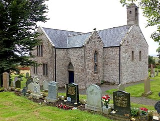
The Kirktown of Fetteresso is a well-preserved village near Stonehaven, Scotland. In the planning area of Kincardine and Mearns, Aberdeenshire, this village contains many very old stone residential structures as well as the Church of St. Ciarans and its associated graveyard. The Carron Water winds through the Kirktown of Fetteresso, and Fetteresso Castle, a listed building, lies at the northwestern verge. Some of the earliest area prehistory has been found nearby on the Fetteresso Estate grounds, where there have been archaeological finds from the Bronze Age.

Marykirk is a village in the Kincardine and Mearns area of Aberdeenshire, Scotland, next to the border with Angus at the River North Esk.

Droop Hill is a mountain landform in the Kincardine and Mearns region of Aberdeenshire, Scotland. The locale had been featured in a windfarm proposal submitted to the Aberdeenshire Council.

Mearns FM is a community run radio station based in the North East of Scotland. There are transmitters in Laurencekirk, Inverbervie, Stonehaven and Portlethen leading to a coverage area stretching from St Cyrus to Aberdeen. The studio is located in Stonehaven.

The Colmeallie stone circle is a recumbent stone circle in Glen Esk, Angus, Scotland. It is located 8 km north of Edzell at Colmeallie Farm, adjacent to the unclassified road leading from the B966 to Tarfside and Loch Lee.

Luthermuir is a village in Aberdeenshire, Scotland, UK.

Lathallan School is a co-educational all-through independent school at Brotherton Castle in Scotland, UK. It also offers outdoor learning programs on its 60-acre campus and an on-site farm.


