Related Research Articles

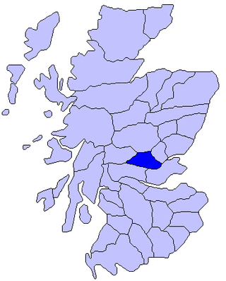
Perthshire, officially the County of Perth, is a historic county and registration county in central Scotland. Geographically it extends from Strathmore in the east, to the Pass of Drumochter in the north, Rannoch Moor and Ben Lui in the west, and Aberfoyle in the south; it borders the counties of Inverness-shire and Aberdeenshire to the north, Angus to the east, Fife, Kinross-shire, Clackmannanshire, Stirlingshire and Dunbartonshire to the south and Argyllshire to the west.
Strathearn or Strath Earn, also the Earn Valley, is the strath of the River Earn, which flows from Loch Earn to meet the River Tay in the east of Scotland.

Aberfeldy is a burgh in Perth and Kinross, Scotland, on the River Tay. A small market town, Aberfeldy is located in Highland Perthshire. It was mentioned by Robert Burns in the poem The Birks Of Aberfeldy and in the Ed Sheeran song The Hills of Aberfeldy.

Crianlarich is a village in Stirling council area and in the registration county of Perthshire, Scotland, around 6 miles (10 km) north-east of the head of Loch Lomond. The village bills itself as "the gateway to the Highlands".
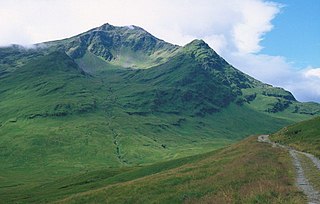
Ben Lui is a mountain in the southern Highlands of Scotland. It is a Munro with a height of 1,130 metres (3,710 ft). Ben Lui is in northeast Argyll and is the highest peak of a mountain chain that includes three other Munros. It has five well-defined ridges radiating out from the summit. Four corries lie between the ridges, including Coirre Gaothaich on the northeast side of the mountain.
Saint Fillan, Filan, Phillan, Fáelán or Faolán is the name of an eighth century monk from Munster, who having studied at Taghmon Abbey, traveled to Scotland and settled at Strath Fillan.

Saint Fillan was a sixth-century Scottish monk active in Fife. His feast day is 20 June.

Strathmore is a broad valley or strath in east-central Scotland, lying between the Grampian mountains and the Sidlaws. It is approximately 50 mi (80 km) long and 10 mi (16 km) wide. Strathmore is underlain by Old Red Sandstone but this is largely obscured by glacial till, sands and gravels deposited during the ice age. Its northeast to southwest alignment is influenced by the underlying geological structure of the area which reflects the dominant Caledonian trend of both the central lowlands and the Highlands of Scotland; its northern margin reflects the presence of the Highland Boundary Fault. Strathmore is fertile and has some of Scotland's best arable farmland, producing soft fruits and cereals.

Strathdon is an area in Aberdeenshire, Scotland. It is situated in the strath of the River Don, 45 miles west of Aberdeen in the Highlands. The main village in the strath is Bellabeg, although it was originally called Invernochty due to its location at the confluence of the River Don and the Water of Nochty. Bellabeg has many of the local community's main facilities.

Strath Fillan Priory was a small Augustinian Priory based at Strath Fillan in Argyll. It seems to have been founded in 1318 by Robert I, King of Scots, and given to the canons of Inchaffray Abbey in order to properly celebrate St Fillan, a saint popular with the 14th century kings of Scotland. It had royal patronage after the Scottish Reformation.

The River Oykel is a major river in northern Scotland that is famous for its salmon fishing. It rises on Ben More Assynt, a few miles from Ullapool on the west coast of Scotland, and drains into the North Sea via the Kyle of Sutherland. Traditionally it has marked the boundary between Ross to the south and Sutherland to the north.
Beinn Chùirn is a hill five kilometres west-south-west of Tyndrum, Scotland, standing on the border of Stirlingshire and Perthshire at the northern extremity of the Loch Lomond and The Trossachs National Park.

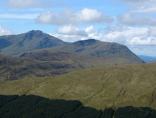
Beinn Challuim is a mountain in the Breadalbane region of the Scottish Highlands. It is east of the village of Tyndrum, in the Forest of Mamlorn, an ancient deer forest at the northern edge of Loch Lomond and the Trossachs National Park. It is a Munro with a height of 1,025 metres (3,363 ft).

Beinn Odhar is a Scottish mountain situated at the northern extremity of the Loch Lomond and the Trossachs National Park. It stands four km (2.5 mi) north of Tyndrum, a location with which it has strong ties, being well seen from the village. The mountain lies on the border between Argyll and Bute and Stirling council areas within the Auch and Invermeran estate.

Breadalbane is a region of the southern/central Scottish Highlands, within the Grampian Mountains range. It is a mountainous region comprising the watershed of Loch Tay; its boundaries are roughly the West Highland Way in the west, Rannoch Moor in the northwest, Loch Rannoch in the north, the River Tummel in the east, the Highland boundary in the southeast, and Loch Earn and Loch Voil-Loch Doine in the south. The former Breadalbane district was surrounded by the districts of Atholl, Strathearn, Menteith, The Lennox, Argyll and Lochaber. The Breadalbane Hydro-Electric Scheme lies within the region.
The Tyndrum Hills are a mountain range located to the south-west of Tyndrum in the Scottish Highlands, within the Strath Fillan and Breadalbane area. They are also within Loch Lomond and the Trossachs National Park and are also known for the famous mountain Ben Lui.
The Crianlarich Hills are a large group of mountains in Scotland, running east of Crianlarich and Loch Lomond, south of Strath Fillan and north of Loch Doine. The range is within the Breadalbane section of Loch Lomond and the Trossachs National Park and contains the highest mountains in the park. The mountains also are located in an area where the landscape becomes ever more remote and mountainous as landscapes go further into a wilderness starting from Tarbet on Loch Lomond. The highest mountain in the range is Ben More, which is also the highest in the national park and is one of the highest in Scotland.

The Skye Marble Railway was a 3 ft narrow gauge industrial railway on the Isle of Skye, Scotland which operated from 1910 to 1912.

The East Highland Way is a long-distance walking route in Scotland that connects Fort William (56.8178°N 5.1109°W) with the ski and mountain resort of Aviemore (57.1899°N 3.8292°W). The route was described by Kevin Langan in 2007. The name is derived from the fact that the route terminates in Aviemore at the eastern edge of Highland region. The EHW route takes in a varied and wild landscape through deep forest plantations, passing many highland lochs and negotiating unspoilt marshlands. The route also explores the ancient Caledonian forests of Inshriach. The walk is 82 miles (132 km) long.
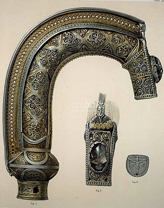
St. Fillan's Crozier is an 8th century Insular crozier crook traditionally associated with the Irish monk St. Fillan, who lived in the eighth century at Glendochart in Perthshire, central Scotland. Only the crook survives; the staff was lost at an unknown date. Sometime around the late 13th century it was encased in the Coigreach, a crosier-shrine of similar size and form built as a protective case, made from silver, gold and rock crystal and dating from the late 13th century, with additions c. the 14th or 15th centuries. The Coigreach was rediscovered in the mid-19th century by the archaeologist Daniel Wilson, who opened it and found St. Fillan's Crozier inside.
References
- ↑ Google Maps, accessed on 3 October 2024
| | This Argyll and Bute location article is a stub. You can help Wikipedia by expanding it. |
| | This Stirling location article is a stub. You can help Wikipedia by expanding it. |