Inverclyde Council

Last updated

Inverclyde Council
Full council election every 4 years.
Coat of Arms Inverclyde.svg
Coat of arms
Inverclyde Council.svg
Council logo
Type
Type
History
Preceded byInverclyde District Council
Leadership
Drew McKenzie,
Independent
since 5 May 2022 [1]
Stephen McCabe,
Labour
since 18 August 2011
Chief Executive
Louise Long
since September 2021 [2]
Structure
Seats22
Political groups
Administration
  Labour (9)
Other parties
  SNP (8)
  Independent (3)
  Conservative (2)
Elections
Single transferable vote
Last election
5 May 2022
Next election
5 May 2027
Meeting place
Town Hall and Municipal Buildings - geograph.org.uk - 323687.jpg
Municipal Buildings, Clyde Square, Greenock, PA15 1LX
Website
www.inverclyde.gov.uk

Inverclyde Council is one of the 32 local authorities of Scotland, covering the Inverclyde council area. In its current form the council was created in 1996, replacing the previous Inverclyde District Council which existed from 1975 to 1996.

Contents

The council has been under no overall control since 2007, being led by a Labour minority administration. The council is based at the Municipal Buildings in Greenock, the area's largest town.

History

Prior to 1975 the area was the western part of the historic county of Renfrewshire. The Local Government (Scotland) Act 1973 replaced Scotland's counties, burghs and districts with a two-tier system comprising upper-tier regions and lower-tier districts. Inverclyde was created as one of nineteen districts within the Strathclyde region. Further reforms in 1996 under the Local Government etc. (Scotland) Act 1994 saw the Strathclyde Regional Council abolished and Inverclyde become a council area, taking over the former regional council's roles in the area. [3]

In 2005, the council was criticised by the Accounts Commission for poor leadership and accountability. [4] The chief executive resigned and various changes to the council's internal structures were made in response. [5] [6]

Until 2007, Inverclyde was the last authority in the United Kingdom not to have named its wards; whilst the local authority reserved its right to name wards, it did not to supply any names to the Local Government Boundary Commission. This was rectified in the 2006 review leading to the new wards used for the 2007 election, although the six multi-member wards created then used only vague geographical descriptions ('Inverclyde North', 'Inverclyde East', 'Inverclyde South West' etc.), in contrast to the majority of wards in Scotland.

Political control

The first election to Inverclyde District Council was held in 1974, initially operating as a shadow authority alongside the outgoing authorities until the new system came into force on 16 May 1975. A shadow authority was again elected in 1995 ahead of the reforms which came into force on 1 April 1996. Political control of the council since 1975 has been as follows: [7]

Inverclyde District Council

Party in controlYears
Labour 1975–1977
Liberal 1977–1980
Labour 1980–1996

Inverclyde Council

Party in controlYears
Labour 1996–2000
No overall control 2000–2003
Liberal Democrats 2003–2007
No overall control 2007–

Leadership

The leaders of the council since 1996 have been: [8]

CouncillorPartyFromTo
Harry Mulholland Labour 1 Apr 19966 May 1999
Robert Jackson Labour 20 May 19991 May 2003
Alan Blair Liberal Democrats 15 May 20033 May 2007
Stephen McCabe Labour 24 May 2007Feb 2011
Iain McKenzie Labour 24 Feb 2011Aug 2011
Stephen McCabe Labour 18 Aug 2011

Composition

Following the Council elections of 2022, the current composition of Inverclyde Council is:

PartyMembers
Labour 9
SNP 8
Independent 3
Conservative 2

The election resulted in no overall control of the council.

Premises

The council is based at the Municipal Buildings on Clyde Square in Greenock. The main building was built in 1886 for the former Greenock Town Council, although the complex also incorporates the earlier Greenock Town Hall of 1765. [9] The buildings passed to Inverclyde District Council at the local government reorganisation in 1975, and then to Inverclyde Council when local government was reorganised again in 1996. [10]

Elections

Since 2007 elections have been held every five years under the single transferable vote system, introduced by the Local Governance (Scotland) Act 2004. Election results since 1995 have been as follows: [7]

YearSeats Labour SNP Conservative Liberal Democrats Independent / Other Notes
1995 20140150Labour majority
1999 20110180New ward boundaries. [11] Labour majority
2003 20600131Lib Dem majority
2007 2095141New ward boundaries. [12]
2012 20106121
2017 2287214New ward boundaries. [13]
2022 2298203

Wards

Map of the council's ward boundaries as of 2017 Inverclyde UK ward map 2017 (blank).svg
Map of the council's ward boundaries as of 2017

Six multi-member wards (20 seats) were created for the 2007 election, replacing 20 single-member wards which had been in place since the 1980s. The representation was increased to 22 councillors across 7 seats for the 2017 election: [14]

Ward
number
Ward nameLocationSeatsPopulation
(2019)
1 Inverclyde East [lower-alpha 1] Inverclyde East.svg 311,340 [15]
2 Inverclyde East Central [lower-alpha 2] Inverclyde East Central.svg 39,512 [16]
3 Inverclyde Central [lower-alpha 3] Inverclyde Central.svg 311,926 [17]
4 Inverclyde North [lower-alpha 4] Inverclyde North.svg 413,759 [18]
5 Inverclyde West [lower-alpha 5] Inverclyde West.svg 310,411 [19]
6 Inverclyde South West [lower-alpha 6] Inverclyde South West.svg 311,649 [20]
7 Inverclyde South [lower-alpha 7] Inverclyde South.svg 39,203 [21]
Total2277,800
  1. Inverclyde East is primarily Kilmacolm plus eastern Port Glasgow (Park Farm etc) and an extensive rural hinterland at Strathgryffe.
  2. Inverclyde East Central covers the majority of Port Glasgow plus Gibshill.
  3. Inverclyde Central covers eastern Greenock and a rural hinterland at Gryffe Reservoirs; created for the 2017 election.
  4. Inverclyde North covers northern and central Greenock.
  5. Inverclyde West covers Gourock.
  6. Inverclyde South West is primarily Inverkip and Wemyss Bay plus south-western Greenock (Larkfield etc) and a rural hinterland at Loch Thom.
  7. Inverclyde South covers southern Greenock.

Related Research Articles

<span class="mw-page-title-main">West Dunbartonshire</span> Council area of Scotland

West Dunbartonshire is one of the 32 local government council areas of Scotland. The area lies to the north-west of the City of Glasgow and contains many of Glasgow's commuter towns and villages. West Dunbartonshire also borders Argyll and Bute, East Dunbartonshire, Renfrewshire and Stirling.

<span class="mw-page-title-main">North Ayrshire</span> Council area of Scotland

North Ayrshire is one of 32 council areas in Scotland. The council area borders Inverclyde to the north, Renfrewshire and East Renfrewshire to the northeast, and East Ayrshire and South Ayrshire to the east and south respectively. The local authority is North Ayrshire Council, formed in 1996 with the same boundaries as the district of Cunninghame which existed from 1975 to 1996.

<span class="mw-page-title-main">East Ayrshire</span> Council area of Scotland

East Ayrshire is one of thirty-two council areas of Scotland. It shares borders with Dumfries and Galloway, East Renfrewshire, North Ayrshire, South Ayrshire and South Lanarkshire. The headquarters of the council are located on London Road, Kilmarnock. With South Ayrshire and the mainland areas of North Ayrshire, it formed the former county of Ayrshire.

<span class="mw-page-title-main">East Renfrewshire</span> Council area of Scotland

East Renfrewshire is one of 32 council areas of Scotland. Until 1975, it formed part of the county of Renfrewshire for local government purposes along with the modern council areas of Renfrewshire and Inverclyde. These three council areas together still form a single lieutenancy area called Renfrewshire.

<span class="mw-page-title-main">Inverclyde</span> Council area of Scotland

Inverclyde is one of 32 council areas used for local government in Scotland. Together with the East Renfrewshire and Renfrewshire council areas, Inverclyde forms part of the historic county of Renfrewshire, which currently exists as a registration county and lieutenancy area. Inverclyde is located in the west central Lowlands. It borders the North Ayrshire and Renfrewshire council areas, and is otherwise surrounded by the Firth of Clyde.

<span class="mw-page-title-main">East Dunbartonshire</span> Council area of Scotland

East Dunbartonshire is one of the 32 council areas of Scotland. It borders the north of Glasgow and contains many of the affluent areas to the north of the city, including Bearsden, Milngavie, Milton of Campsie, Balmore and Torrance, as well as many of the city's commuter towns and villages. East Dunbartonshire also shares borders with North Lanarkshire, Stirling and West Dunbartonshire. The council area covers parts of the historic counties of Dunbartonshire, Lanarkshire and Stirlingshire.

<span class="mw-page-title-main">North Lanarkshire</span> Council area of Scotland

North Lanarkshire is one of 32 council areas of Scotland. It borders the north-east of the City of Glasgow and contains many of Glasgow's suburbs and commuter towns and villages. It also borders East Dunbartonshire, Falkirk, Stirling, South Lanarkshire and West Lothian. The council area covers parts of the historic counties of Dunbartonshire, Lanarkshire and Stirlingshire. The council is based in Motherwell.

<span class="mw-page-title-main">Renfrewshire</span> Council area of Scotland

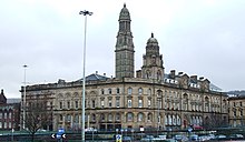
Renfrewshire is one of the 32 council areas of Scotland.

<span class="mw-page-title-main">Glasgow City Council</span> Scottish unitary authority council in Glasgow, Scotland, UK

Glasgow City Council is the local government authority for the city of Glasgow, Scotland. In its modern form it was created in 1996. Glasgow was formerly governed by a corporation, also known as the town council, from the granting of its first burgh charter in the 1170s until 1975. From 1975 until 1996 the city was governed by City of Glasgow District Council, a lower-tier authority within the Strathclyde region.

<span class="mw-page-title-main">Strathclyde</span> Former local government region of Scotland

Strathclyde was one of nine former local government regions of Scotland created in 1975 by the Local Government (Scotland) Act 1973 and abolished in 1996 by the Local Government etc. (Scotland) Act 1994. The Strathclyde region had 19 districts. The region was named after the medieval Kingdom of Strathclyde but covered a broader geographic area than its namesake.

<span class="mw-page-title-main">Cumbernauld and Kilsyth (district)</span>

<span class="mw-page-title-main">Clydesdale (district)</span>

<span class="mw-page-title-main">Renfrew (district)</span>

<span class="mw-page-title-main">Renfrewshire (historic)</span> Historic county and lieutenancy area of western Scotland

Renfrewshire or the County of Renfrew is a historic county, registration county and lieutenancy area in the west central Lowlands of Scotland. The lieutenancy area covers the three modern council areas of Inverclyde, Renfrewshire and East Renfrewshire, and this area is occasionally termed Greater Renfrewshire to distinguish it from the modern council area called Renfrewshire. The historic county additionally included territory on the south-western edge of Glasgow which was gradually transferred to the administrative area of the city as it grew.

Greenock and Port Glasgow was a burgh constituency of the House of Commons of the Parliament of the United Kingdom from 1974 until 1997, electing one Member of Parliament (MP) by the first past the post system of election.

<span class="mw-page-title-main">Dumbarton (district)</span> Former local government district in Scotland

<span class="mw-page-title-main">Motherwell (district)</span> Former local government district in Strathclyde, Scotland

<span class="mw-page-title-main">Hamilton (district)</span>

<span class="mw-page-title-main">East Kilbride (district)</span>

<span class="mw-page-title-main">City of Edinburgh Council</span> Local government body in Scotland

The City of Edinburgh Council is the local government authority covering the City of Edinburgh council area. The majority of the council area is the area of Edinburgh, capital of Scotland. With a population of 518,500 in mid-2019, it is the second most populous local authority area in Scotland.

References

  1. "Provost appointed".
  2. "Louise is new chief". Inverclyde Council. Retrieved 14 February 2023.
  3. "Local Government etc. (Scotland) Act 1994", legislation.gov.uk , The National Archives, 1994 c. 39, retrieved 14 February 2023
  4. "Council urged to tackle failings". BBC News. 2 June 2005. Retrieved 8 July 2006.
  5. "Council given deadline to improve". BBC News. 30 November 2005. Retrieved 8 July 2006.
  6. "Inverclyde starts big changes at the top". The Herald. 23 June 2006. Archived from the original on 1 July 2013. Retrieved 8 July 2006.
  7. 1 2 "Compositions calculator". The Elections Centre. Retrieved 14 February 2023.
  8. "Council minutes". Inverclyde Council. Retrieved 14 February 2023.
  9. Historic Environment Scotland. "Municipal Buildings, Clyde Square (Wallace Place / Dalrymple Street) (LB34122)" . Retrieved 14 February 2023.
  10. "Contact us". Inverclyde Council. Retrieved 14 February 2023.
  11. "The Inverclyde (Electoral Arrangements) Order 1998", legislation.gov.uk , The National Archives, SI 1998/3074, retrieved 14 February 2023
  12. Scottish Parliament. The Inverclyde (Electoral Arrangements) Order 2006 as made, from legislation.gov.uk .
  13. Scottish Parliament. The Inverclyde (Electoral Arrangements) Order 2016 as made, from legislation.gov.uk .
  14. "United Kingdom: Scotland | Council Areas and Electoral Wards". City Population. 30 June 2019. Retrieved 28 March 2021.
  15. Electoral Ward: Inverclyde East, Scottish Government Statistics
  16. Electoral Ward: Inverclyde East Central, Scottish Government Statistics
  17. Electoral Ward: Inverclyde Central, Scottish Government Statistics
  18. Electoral Ward: Inverclyde North, Scottish Government Statistics
  19. Electoral Ward: Inverclyde West, Scottish Government Statistics
  20. Electoral Ward: Inverclyde South West, Scottish Government Statistics
  21. Electoral Ward: Inverclyde South, Scottish Government Statistics