Queen Elizabeth Forest Park | |
---|---|
![]() A map showing the location of the Queen Elizabeth Forest Park (in red) in central Scotland, alongside the location of other forest parks (in green) | |
Map | |
Geography | |
Location | Highlands,Scotland |
Coordinates | 56°10′N4°27′W / 56.17°N 4.45°W |
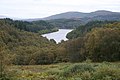
Queen Elizabeth Forest Park is a 19,665-hectare (48,590-acre) [1] forest park in the Scottish Highlands which extends from the eastern shores of Loch Lomond to the mountains of Strathyre. The forest park is one of six such parks in Scotland, and was established in 1953, [2] the year of the coronation of Elizabeth II. It is owned and managed by Forestry and Land Scotland.
The park is part of Loch Lomond and The Trossachs National Park and is a sparsely-populated region of mountains, hills, lochs and valleys. Most of the upland areas are bare and uncultivated, while much of the lowland is densely forested.
Within the park are several mountains including Ben Lomond, which at 974 m (3,196 ft) is the highest point, Ben Venue (727 m; 2,385 ft) and Ben Ledi (879 m; 2,884 ft). Its lakes and reservoirs include Loch Ard, Loch Chon, Loch Venachar, Loch Arklet, Loch Katrine, Loch Achray and Loch Drunkie. Its forests include Achray Forest, Buchanan Forest, Strathyre Forest and Loch Ard Forest.
The main visitor centre for the area is The Lodge Forest Visitor Centre at Aberfoyle on the edge of the highlands on the eastern hillside of Craigmore (354 m; 1,161 ft). There are marked hiking trails and a car trail, the Three Lochs Forest Drive.
Aberfoyle is a village in the historic county and registration county of Perthshire and the council area of Stirling, Scotland. The settlement lies 27 miles northwest of Glasgow.
The West Highland Way is a linear long-distance route in Scotland. It is 154 km long, running from Milngavie north of Glasgow to Fort William in the Scottish Highlands, with an element of hill walking in the route. The trail, which opened in 1980, was Scotland's first officially designated Long Distance Route, and is now designated by NatureScot as one of Scotland's Great Trails. It is primarily intended as a long distance walking route, and whilst many sections are suitable for mountain biking and horseriding there are obstacles and surfaces that will require these users to dismount in places.
The Stirling council area is one of the 32 council areas of Scotland, and has an estimated population of 92,530 (2022). It was created in 1975 as a lower-tier district within the Central region. The district covered parts of the historic counties of Stirlingshire and Perthshire, which were abolished for local government purposes. In 1996 the Central region was abolished and Stirling Council took over all local government functions within the area.
Loch Lomond and The Trossachs National Park is a national park in Scotland centred on Loch Lomond and the hills and glens of the Trossachs, along with several other ranges of hills. It was the first of the two national parks established by the Scottish Parliament in 2002, the second being the Cairngorms National Park. The park extends to cover much of the western part of the southern highlands, lying to the north of the Glasgow conurbation, and contains many mountains and lochs. It is the fourth-largest national park in the British Isles, with a total area of 1,865 km2 (720 sq mi) and a boundary of some 350 km (220 mi) in length. It features 21 Munros and 20 Corbetts.
Ben Lomond, 974 metres (3,196 ft), is a mountain in the Scottish Highlands. Situated on the eastern shore of Loch Lomond, it is the most southerly of the Munros. Ben Lomond lies within the Ben Lomond National Memorial Park and the Loch Lomond and The Trossachs National Park, property of the National Trust for Scotland.
The Trossachs generally refers to an area of wooded glens, braes, and lochs lying to the east of Ben Lomond in the Stirling council area of Scotland. The name is taken from that of a small woodland glen that lies at the centre of the area, but is now generally applied to the wider region.
The Arrochar Alps are a group of mountains located around the heads of Loch Long, Loch Fyne, and Loch Goil. They are part of the Grampian mountains range, which stretch across Scotland. The villages of Arrochar and Lochgoilhead are the nearest settlements. Many of the mountains are located on the Cowal Peninsula in Argyll and Bute, west of Scotland.
Loch Ard is a loch, located in Loch Lomond and the Trossachs National Park, Stirling council area, Scotland.
Ben Ledi is a mountain in Stirling, Scotland. It is 879 metres high, and is therefore classified as a Corbett. It lies about six kilometres northwest of Callander, near the village of Kilmahog. It is situated in the Trossachs, an area often regarded as having some of the most romantic scenery in the Highlands.
Beinn an Lochain is a mountain in the Arrochar Alps in western Scotland. A Corbett, reaching 901.7 metres (2,958 ft), Beinn an Lochain is situated within the Argyll Forest Park, which is itself within the Loch Lomond and the Trossachs National Park.
Loch Venachar is a freshwater loch in Stirling district, Scotland.
Loch Achray is a small freshwater loch 11 km (6.8 mi) west of Callander in Stirling district, Scotland.
Glen Croe is a glen in the heart of the Arrochar Alps on the Cowal Peninsula, in Argyll and Bute, west of Scotland. The glen is surrounded by large and rugged mountains characterised by huge boulders. The Croe Water flows through the glen and into Loch Long.
Strathyre is a district and settlement in the Stirling local government district of Scotland. It forms the south-eastern part of the parish of Balquhidder and was, prior to the 1973 reorganisation of local government, part of Perthshire. It is within the bounds of the Loch Lomond and the Trossachs National Park. In Gaelic, the district is Srath Eadhair and the village is An t-Iomaire Riabhach or an t-Iomaire Fada.
Benvane is a mountain in the Trossachs, in Stirling council area, Scotland. It lies within Loch Lomond and The Trossachs National Park and the Queen Elizabeth Forest Park, and the summit is on the western boundary of the Trossachs National Nature Reserve. It is 821 metres (2,694 ft) high, and is classified as a Corbett, being joined by a ridge to the neighbouring Corbett of Ben Ledi.
Ben A'an is a hill in the Trossachs in Scotland. The pointed peak of its west top resembles a small mountain.
Duchray Water, also called Dachray Water, is a 14-mile-long (23 km) headstream of the River Forth in the Trossachs region of Scotland.
Beinn an Fhogharaidh is a mountain ridge, 616 metres (2,021 ft) high, in the southern Scottish Highlands near the village of Aberfoyle in Stirling council area, Scotland.
The Great Trossachs Path is a 48-kilometre (30 mi) long-distance footpath through the Trossachs, in the Stirling council area of Scotland. It runs between Callander in the east and Inversnaid on the banks of Loch Lomond in the west, passing along the northern shores of Loch Katrine and Loch Arklet. The path is suitable for walkers and cyclists; much of the route is also suitable for experience horse riders, although the middle section along the shoreline of Loch Katrine is tarmacked and so may not be ideal for horses.
Glen Mhor is a short glen located in the Arrochar Alps, within the Cowal Peninsula, Argyll and Bute, west of Scotland. The B828 goes through the glen, linking the top of Glen Croe (A83) at the Rest & be Thankful viewpoint in the east, in the west with the Hell's Glen (B839).