
Aberfoyle is a village in the historic county and registration county of Perthshire and the council area of Stirling, Scotland. The settlement lies 27 miles northwest of Glasgow.

The River Forth is a major river in central Scotland, 47 km (29 mi) long, which drains into the North Sea on the east coast of the country. Its drainage basin covers much of Stirlingshire in Scotland's Central Belt. The Gaelic name for the upper reach of the river, above Stirling, is Abhainn Dubh, meaning "black river". The name for the river below the tidal reach is Uisge For.

Loch Katrine is a freshwater loch in the Trossachs area of the Scottish Highlands, east of Loch Lomond within the Stirling council area. It mostly lies within the historic and registration county of Perthshire, with Glengyle Water and the northern part of the loch's mid-line forming part of the boundary with historic Stirlingshire. The loch is about 8 miles (13 km) long and 1 mile (1.6 km) wide at its widest point, and runs the length of Strath Gartney. It is within the drainage basins of the River Teith and River Forth.
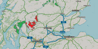
Loch Lomond and The Trossachs National Park is a national park in Scotland centred on Loch Lomond and the hills and glens of the Trossachs, along with several other ranges of hills. It was the first of the two national parks established by the Scottish Parliament in 2002, the second being the Cairngorms National Park. The park extends to cover much of the western part of the southern highlands, lying to the north of the Glasgow conurbation, and contains many mountains and lochs. It is the fourth-largest national park in the British Isles, with a total area of 1,865 km2 (720 sq mi) and a boundary of some 350 km (220 mi) in length. It features 21 Munros and 20 Corbetts.

Ben Lomond, 974 metres (3,196 ft), is a mountain in the Scottish Highlands. Situated on the eastern shore of Loch Lomond, it is the most southerly of the Munros. Ben Lomond lies within the Ben Lomond National Memorial Park and the Loch Lomond and The Trossachs National Park, property of the National Trust for Scotland.
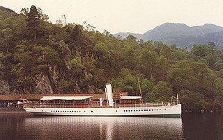
SS Sir Walter Scott is a small steamship that has provided pleasure cruises and a ferry service on Loch Katrine in the scenic Trossachs of Scotland for more than a century, and is the only surviving screw steamer in regular passenger service in Scotland. She is named after the writer Walter Scott, who set his 1810 poem Lady of the Lake, and his 1818 novel Rob Roy around Loch Katrine.

The Trossachs generally refers to an area of wooded glens, braes, and lochs lying to the east of Ben Lomond in the Stirling council area of Scotland. The name is taken from that of a small woodland glen that lies at the centre of the area, but is now generally applied to the wider region.

The Cobbler is an 884 metres (2,900 ft) mountain located near the head of Loch Long in Argyll and Bute, Scotland. It is a Corbett, and is an important site for rock climbing in the Southern Highlands. Many maps include the name Ben Arthur, but the name The Cobbler is more widely used. In the 19th century it was referred to as The Cobbler and his Wife.

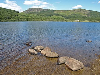
Loch Ard is a loch, located in Loch Lomond and the Trossachs National Park, Stirling council area, Scotland.
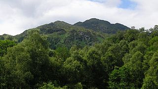
Ben Venue is a mountain in the Trossachs area of Scotland. The name Ben Venue is derived from the Scottish Gaelic words meaning "the miniature mountain". The summit lies approximately 2 kilometres south-west of the pier at the southern end of Loch Katrine. At the foot of the mountain close to the shore of Loch Katrine is Bealach nam Bò meaning the "pass of the cattle", a reference to the lawless days when Highland cattle "lifters" used the pass to drive stolen herds to their land.

Ben Vane is a mountain in the Arrochar Alps of Argyll, in the Southern Highlands of Scotland. It reaches 915 metres (3,002 ft), making it a Munro. It lies between Beinn Ìme and Ben Vorlich.

Beinn Dubhchraig is a mountain in the Scottish Highlands, west of Crianlarich in the northern part of Loch Lomond and the Trossachs National Park. It is a Munro with a height of 978 metres (3,209 ft). It is overshadowed by its neighbour Ben Lui, although it is well seen from the main A82 road. Its name means "mountain of the black rock", referring to the steep and rocky face on the southwest slopes above Loch Oss, which offer scrambling routes to the summit.
The Glasgow to Aberfoyle Line was a railway line in Scotland, built in stages, leaving the Edinburgh and Glasgow Railway near Lenzie. Tourist traffic was a dominant part of the motivation for building the line, and road tours to the Trossachs from Aberfoyle formed a significant part of the traffic.
National Cycle Route 7 is a route of the United Kingdom National Cycle Network, running from Sunderland to Inverness.

Inversnaid is a small rural community on the east bank of Loch Lomond in Scotland, near the north end of the loch. It has a pier and a hotel, and the West Highland Way passes through the area. A small passenger ferry runs from Inversnaid to Inveruglas on the opposite shore of the loch, and also to Tarbet. There is a seasonal ferry that also operates between Ardlui and Ardleish as well, which is a walkable distance from Inversnaid. To reach Inversnaid by road involves a 15-mile (24-kilometre) route from Aberfoyle. Nearby is an alleged hideout of Rob Roy MacGregor known as Rob Roy's Cave. The cave is difficult to access, and is best seen from Loch Lomond, where there is white paint indicating the location of the hideout.
Loch Chon is a freshwater loch situated west of the village of Aberfoyle, near the small village of Kinlochard, Stirling, Scotland, UK. Loch Chon lies upstream of Loch Ard and to the south of Loch Katrine.

Beinn Mhòr is the highest mountain on the Cowal Peninsula, west of Loch Eck in Argyll and Bute, west of Scotland. It has a high topographic prominence to height ratio and consequently commands a good all round view.
The Strathendrick and Aberfoyle Railway was a railway line in Scotland.

Beinn an Fhogharaidh is a mountain ridge, 616 metres (2,021 ft) high, in the southern Scottish Highlands near the village of Aberfoyle in Stirling council area, Scotland.
Queen Elizabeth Forest Park is a 19,665-hectare (48,590-acre) forest park in the Scottish Highlands which extends from the eastern shores of Loch Lomond to the mountains of Strathyre. The forest park is one of six such parks in Scotland, and was established in 1953, the year of the coronation of Elizabeth II. It is owned and managed by Forestry and Land Scotland.

