Old Aberdeen

Last updated

Old Aberdeen
Coat of Arms of Old Aberdeen.jpg
Arms of Old Aberdeen
Aberdeen UK location map.svg
Red pog.svg
Old Aberdeen
Location within the Aberdeen City council area
Scotland location map.svg
Red pog.svg
Old Aberdeen
Location within Scotland
OS grid reference NJ939082
Council area
Lieutenancy area
  • Aberdeen
Country Scotland
Sovereign state United Kingdom
Post town ABERDEEN
Postcode district AB24
Dialling code 01224
Police Scotland
Fire Scottish
Ambulance Scottish
UK Parliament
Scottish Parliament
Website oldaberdeen.org.uk
List of places
UK
Scotland
57°09′53″N2°06′09″W / 57.1648°N 2.1024°W / 57.1648; -2.1024

Old Aberdeen is part of Aberdeen in Scotland. Old Aberdeen was originally a separate burgh, which was erected into a burgh of barony on 26 December 1489. It was incorporated into adjacent Aberdeen by Act of Parliament in 1891. It retains the status of a community council area. [1]

Contents

The town's motto is "concordia res parvae crescunt" ("through harmony, small things increase").

Location

The Old Town House The Town House, Old Aberdeen - geograph.org.uk - 3417187.jpg
The Old Town House
College Bounds, Old Aberdeen Old Aberdeen High Street.jpg
College Bounds, Old Aberdeen
King's College, High Street, Old Aberdeen Oldkingsaberdeen.jpg
King's College, High Street, Old Aberdeen
Powis Gates Aberdeen gates.jpg
Powis Gates

Located to the north of Aberdeen city centre, Old Aberdeen was for a long time fairly isolated at the edge of the city, being followed to the north by the River Don, Seaton Park and the small Brig o' Balgownie hamlet. Since the 1960s, and the North Sea oil boom of the 1970s, however, housing development has surrounded the area, in particular with the nearby Tillydrone development.

History

Old Aberdeen was an important political, ecclesiastical and cultural centre since the Late Middle Ages. It was distinct from the more commercial New Aberdeen and they remained separate cities until 1891. [2] In the 1630s the Covenanters challenged the Doctors of Aberdeen by holding a meeting in Muchalls Castle and responding to certain letters issued by the doctors, thus setting the stage for the first battle of the Bishops' Wars, when William Keith, 7th Earl Marischal and the Marquess of Montrose led a Covenanter army of 9,000 men over the Causey Mounth to attack forces at the Bridge of Dee, [3] effectively gaining control of Old Aberdeen.

Character and land use

The central part of the old town is a conservation area rich in historical buildings, some dating to the Middle Ages, and many vernacular buildings of the 17th-early 19th centuries built in the locally ubiquitous grey granite. A notable feature of the later buildings is the early use of hand-made bricks to build up gables, top garden walls, etc.; this use of brick being rare elsewhere in Scotland before the late 19th century. A number of the streets remain paved with stone setts. There are also several university buildings from the late 20th century.

Old Aberdeen is effectively the main campus of the University of Aberdeen. There are also residential and commercial properties, but many of these are owned by the university or owned by the staff and students of the university. Additionally the area includes a small police station, a pub, a bakery, and until recently its own Post Office. To the north of the university lies St Machar's Cathedral, whose medieval ecclesiastical buildings formed the original Old Aberdeen before the University arrived in 1495.

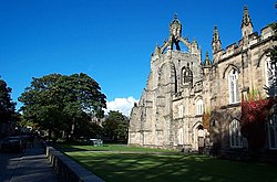
Major historic buildings in Old Aberdeen include: the late 15th Century King's College Chapel, one of two surviving Scottish medieval churches with open "crown" spires, and which has the largest surviving collection of medieval woodcarving in any Scottish building; St Machar's Cathedral itself; the recently restored Old Town House (early 18th century); and the Brig o' Balgownie (14th Century), now pedestrianised, and which is a contender for the title of Scotland's oldest surviving bridge.

Governance

Old Aberdeen is now fully incorporated into the Aberdeen City council area, with its local authority as Aberdeen City Council. Old Aberdeen remains a community council area within the city. [4] For elections to Aberdeen City Council, Old Aberdeen forms part of the 'Tillydrone/ Seaton/Old Aberdeen' electoral ward, which elects three councillors. These are currently Jim Noble, Alex McLellan (both SNP), and Ross Grant (Labour) [5]

For elections to the House of Commons in the Parliament of the United Kingdom, Old Aberdeen forms part of the Aberdeen North constituency. The current Member of Parliament (MP) for Aberdeen North is Kirsty Blackman. For elections to the Scottish Parliament, it elects a constituency member as part of the Aberdeen Central constituency. The current Member of the Scottish Parliament for Aberdeen Central is Kevin Stewart. [6]

Landmarks

King's College and Old Aberdeen campus

The iconic and renowned buildings of King's College are perhaps the dominant structures of Old Aberdeen. The College itself now finds itself surrounded by the wider Old Aberdeen campus of the University of Aberdeen which, since the decline of Marischal College, is now the main focal point of the university. The area boasts two museums, King's Museum, which features changing exhibitions from the stores of the University and the Zoology Museum, home to the natural history collection belonging to the University.

The Old Town House

The Old Town House was the original home of the Burgh's local government, completed in 1789. It was originally the centrepoint for trading in Old Aberdeen (still discernible in the widening of the street to accommodate trading booths), and the mercat cross (head late medieval, shaft more recent) stands outside it. The building is built of granite and is of restrained but elegant early Georgian design, with a fine cupola above the façade. It was acquired by the university in recent years, and was renovated in 2005. The Old Town House now houses King's Museum. [7]

St Machar's Cathedral

St Machar's Cathedral St. Machar's Cathedral tower, Aberdeen.jpg
St Machar's Cathedral

The Cathedral Church of St Machar is the high kirk of Aberdeen and following the Reformation lies in the hands of the Church of Scotland.

Cruickshank Botanic Gardens

The Cruickshank Botanic Gardens were gifted to the University of Aberdeen and opened in 1898. The gardens are set over 11 acres (45,000 m2) and are accessible to the public for no charge.

The Powis Gates

Just south of King's College and across the High Street lie the Powis Gates, an impressive and imposing archway with a Near Eastern influence demonstrated in its 'minaret' towers. These were erected in 1834 by Hugh Fraser Leslie of Powis, the owner of an estate which formerly lay behind them. The Fraser Leslie Arms are visible on the obverse of the arch, with a shield on the reverse showing the bust of three black men - a link to the family's involvement in a grant of freedom made to their slaves in Jamaica (or possibly impaled arms celebrating a marriage between a member of the Leslie family and a member of the Moir of Scotstoun family). The entrance now leads to the University's Crombie-Johnston and King's Postgraduate Halls of Residence. [8]

Seaton Park

To the north boundary of Old Aberdeen lies Seaton Park, one of the city's largest open spaces. The park itself lies on the banks of the River Don. It is set over twenty-seven hectares and was purchased by the city for public use in 1947.

Related Research Articles

<span class="mw-page-title-main">University of Aberdeen</span> Public research university in Scotland

The University of Aberdeen is a public research university in Aberdeen, Scotland. It was founded in 1495 when William Elphinstone, Bishop of Aberdeen and Chancellor of Scotland, petitioned Pope Alexander VI on behalf of James IV, King of Scots to establish King's College, making it one of Scotland's four ancient universities and the fifth-oldest university in the English-speaking world. Along with the universities of St Andrews, Glasgow, and Edinburgh, the university was part of the Scottish Enlightenment during the 18th century.

<span class="mw-page-title-main">Kincardineshire</span> Historic county in Scotland

Kincardineshire, also known as the Mearns, is a historic county, registration county and lieutenancy area on the coast of northeast Scotland. It is bounded by Aberdeenshire on the north and west, and by Angus on the south.

<span class="mw-page-title-main">Brig o' Balgownie</span> 13th century bridge in Aberdeen, Scotland

The Brig o' Balgownie is a 13th-century bridge spanning the River Don in Old Aberdeen, Scotland.

<span class="mw-page-title-main">Marischal College</span> Civic Building in Aberdeen, Scotland

Marischal College is a large granite building on Broad Street in the centre of Aberdeen in north-east Scotland, and since 2011 has acted as the headquarters of Aberdeen City Council. However, the building was constructed for and is on long-term lease from the University of Aberdeen, which still uses parts of the building to store its museum collections. Today, it provides corporate office space and public access to council services, adjacent to the Town House, the city's historic seat of local government. Many Aberdonians consider Marischal College to be an icon of the "Granite City" and to symbolise the zenith of Aberdeen's granite-working industry.

<span class="mw-page-title-main">Kintore, Aberdeenshire</span> Human settlement in Scotland

Kintore is a town and former royal burgh near Inverurie in Aberdeenshire, Scotland, now bypassed by the A96 road between Aberdeen and Inverness. It is situated on the banks of the River Don.

<span class="mw-page-title-main">Aberdeen North (UK Parliament constituency)</span> Parliamentary constituency in the United Kingdom, 1885 onwards

Aberdeen North is a burgh constituency of the House of Commons of the Parliament of the United Kingdom and it elects one Member of Parliament (MP) by the first past the post system of election. It was first used in the 1885 general election, but has undergone various boundary changes since that date.

<span class="mw-page-title-main">Findon, Aberdeenshire</span>

Findon is a fishing village eight miles south of Aberdeen, famous for originating the smoked haddock known as Finnan haddie. The Findon moor has a number of paths through it, many of which run along the cliffs. Deer can often be seen there. Nearby features include the Portlethen Moss Nature Reserve.

Portlethen is a town located approximately 7 miles south of Aberdeen, Scotland along the A92. The population according to the 2011 census was 7,130 making it the seventh most populous settlement within Aberdeenshire.

<span class="mw-page-title-main">Tillydrone</span> Human settlement in Scotland

Tillydrone is an area of Aberdeen, Scotland. Lying north of the city centre and slightly north-west of Old Aberdeen, it is roughly bounded by the River Don, St Machar Drive, and the main Aberdeen-Inverness railway line.

<span class="mw-page-title-main">Portlethen Village</span>

Portlethen Village is a settlement located to the east of Portlethen along the North Sea coast in Aberdeenshire, Scotland. The village is also known as Old Portlethen. The skerry of Craigmaroinn is situated just off the coastline near Portlethen Village.

<span class="mw-page-title-main">Downies</span>

Downies is a cliff-top village in Aberdeenshire, Scotland situated on Cammachmore Bay. Historically Downies was a fishing village, until much of the local North Sea fishery collapsed from overfishing; presently Downies is chiefly a residential dormitory adjunct to the city of Aberdeen.

<span class="mw-page-title-main">Architecture of Aberdeen</span> Buildings in Aberdeen, Scotland (UK)

The architecture of Aberdeen, Scotland, is known for the use of granite as the principal construction material. The stone, which has been quarried in and around the city, has given Aberdeen the epithet The Granite City, or more romantically, and less commonly used, the Silver City, after the mica in the stone which sparkles in the sun.

<span class="mw-page-title-main">History of Aberdeen</span> Aspect of history

There has been a human presence in the area of Aberdeen since the Stone Age. Aberdeen as a city, grew up as two separate burghs: Old Aberdeen, the university and cathedral settlement, at the mouth of the River Don; and New Aberdeen, a fishing and trading settlement where the Denburn entered the Dee estuary.

<span class="mw-page-title-main">Bridge of Dee</span>

The Bridge of Dee or Brig o Dee is a road bridge over the River Dee in Aberdeen, Scotland. The term is also used for the surrounding area of the city. Dating from 1527, the bridge crosses at what was once the City of Aberdeen's southern boundary.

<span class="mw-page-title-main">Nigg, Aberdeen</span> Human settlement in Scotland

Nigg is an area of Aberdeen, Scotland, south of the River Dee. It has a population of 16,500. The area has a bay known as the Bay of Nigg or Nigg Bay, immediately south of a coastal golf course, and a farm that is also a visitor attraction, known as Doonies Farm.

<span class="mw-page-title-main">Causey Mounth</span>

The Causey Mounth is an ancient drovers' road over the coastal fringe of the Grampian Mountains in Aberdeenshire, Scotland. This route was developed as the main highway between Stonehaven and Aberdeen around the 12th century AD and it continued to function as the principal route connecting these two cities until the mid 20th century, when modern highway construction of the A90 road occurred in this area. There are extant paved and usable sections of this road over part of the alignment; however, many parts of the ancient route are no more than footpaths, and in some cases the road has vanished into agricultural fields. Constructed in the Middle Ages, the Causey Mounth was created as an elevated rock causeway to span many of the boggy areas such as the Portlethen Moss. A considerable portion of the alignment of the Causey Mounth is illustrated on the UK Ordnance Survey Map, although a large fraction of the route cannot be navigated by a conventional passenger vehicle.

<span class="mw-page-title-main">Cammachmore</span>

Cammachmore is a hamlet in the coastal region near the North Sea in Aberdeenshire. It lies slightly west of the A92 road and the ancient Causey Mounth passes through the community. Historic Elsick House is situated due west of Cammachmore. Other nearby historic features include Gillybrands, Saint Ternan's Church, Muchalls Castle and the Lairhillock Inn.

The Bede House in Old Aberdeen, Scotland, is a 17th-century Scottish town house. It was built in 1676 as a residence for Bailie William Logan and his wife Jean Moir of Stoneywood. During the late 18th century, Old Aberdeen Bedesmen moved from their original hospital beside St Machar's Church to the former Logan house in Don Street. In the 19th century the house changed hands. It was first owned by the Burgh of Old Aberdeen, then, by the City of Aberdeen after the merger of the two burghs in 1891. The house was refurbished by the City of Aberdeen Council in 1965. It was divided into two flats or apartments. The flats are now in private ownership. Much of the 17th-century building is in its original form. It is an excellent example of an L-shaped Scottish Town House, built on three floors with an attic. The house is designated as a Category A listed building.

<span class="mw-page-title-main">Mitchell's Hospital Old Aberdeen</span> Hospital in Scotland

Mitchell's Hospital, Old Aberdeen, in Old Aberdeen, Scotland, was founded by the philanthropist David Mitchell in 1801 as follows: " .. from a regard for the inhabitants of the city of Old Aberdeen and its ancient college and a desire in these severe times to provide lodging, maintenance and clothing for a few aged relicks and maiden daughters of decayed gentlemen merchants or trade burgesses of the said city.. ". See the text of the 1801 Mortification or the conditions of the endowment. The Hospital is owned and managed by the University of Aberdeen, Aberdeen City Council and the Cathedral Church of St Machar in Old Aberdeen. The origins of the Hospital are due to various attempts by the Incorporated Trades and Merchants in Old Aberdeen to provide a "care home" for their elderly and infirm members and their "relicks".

References

  1. "OACC - map of the area". Archived from the original on 25 January 2009. Retrieved 20 July 2009.
  2. Hoiberg, Dale H., ed. (2010). "Aberdeen" . Encyclopædia Britannica. Vol. I: A-ak Bayes (15th ed.). Chicago, Illinois: Encyclopædia Britannica Inc. pp.  27–28. ISBN   978-1-59339-837-8.
  3. C.Michael Hogan, Causey Mounth, Megalithic Portal, ed. by Andy Burnham, 3 November 2007
  4. "Old Aberdeen Community Council". oldaberdeen.org.uk.
  5. "Aberdeen Performs". 29 July 2021.
  6. http://www.oldaberdeen.org.uk/page6.html%5B%5D
  7. "The Old Town House". Aberdeen University. Retrieved 28 July 2022.
  8. "Walking with History" (PDF). University of Aberdeen . Retrieved 27 September 2008.