Buchan is a coastal district in the north-east of Scotland, bounded by the Ythan and Deveron rivers. It was one of the original provinces of the Kingdom of Alba. It is now one of the six committee areas of Aberdeenshire.

Banffshire is a historic county in Scotland. The county town is Banff, although the largest settlement is Buckie to the west. The historic county ceased to be used for local government purposes in 1975. Since 1996 the area has been split between the Aberdeenshire and Moray council areas. The historic county boundaries of Banffshire are still used for certain functions, being a registration county and lieutenancy area.

The Loch of Strathbeg is a shallow freshwater loch on the coast of Buchan in Aberdeenshire, Scotland. It lies within the parishes of Lonmay and Crimond. The loch is a designated special protection area because of its importance to birdlife and is managed by the Royal Society for the Protection of Birds, which operates a visitor centre at Starnafin. It is visited in the winter months by at least 20,000 birds, including pink-footed geese, whooper swans, and teals.
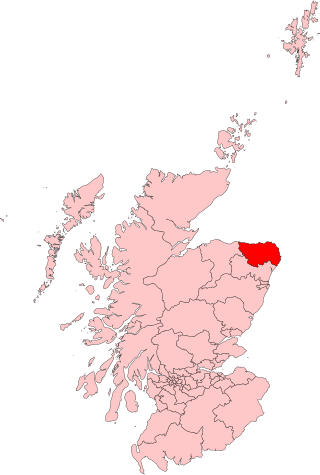
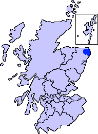
Banff and Buchan was a constituency of the House of Commons, located in the north-east of Scotland within the Aberdeenshire council area. It elected one Member of Parliament at least once every five years using the first-past-the-post system of voting.
EastAberdeenshire was a Scottish county constituency of the House of Commons of the Parliament of the United Kingdom from 1868 to 1918 and from 1950 to 1983. It elected one Member of Parliament (MP) by the first past the post system of election.

King Edward is a small village, parish and former feudal barony near the north coast of Scotland in Buchan midway between Turriff and Banff.

Cairness House, 4.5 miles (7 km) south-east of Fraserburgh in Buchan in the county of Aberdeenshire, is a country house built in the Neoclassical style between 1791 and 1797 to designs by architect James Playfair. It replaced an earlier house of 1781 by Robert Burn, which was in part incorporated into the Playfair scheme. Sir John Soane assisted in the final stages of the construction after Playfair's death in 1794. The park was laid out by Thomas White, a follower of Lancelot 'Capability' Brown.

Auchterless is a village in Aberdeenshire, Scotland; grid reference NJ 713 416, postcode AB53 8BG. The nearest large settlement is Turriff. It is traditionally known as "Kirkton of Auchterless".

New Aberdour is a small planned village in the Aberdour parish of Aberdeenshire, Scotland, situated south of Aberdour Bay on the Moray Firth. It lies 7 miles (11 km) west of Fraserburgh. One of the earliest churches in Scotland is said to have been founded here in 580 AD by Saint Drostan and Saint Columba.

The Formartine and Buchan Way is a long-distance trail in Scotland, extending from Dyce north to Peterhead and Fraserburgh in the Buchan and Formartine districts of Aberdeenshire in Scotland. It follows the track of a former railway line, the Formartine and Buchan Railway, and is open to walkers, cyclists and horse riders. The railway closed in 1979 (Fraserburgh) and 1970 (Maud-Peterhead). The walkway opened in the early 1990s, and is managed by Aberdeenshire Council. It is listed as one of Scotland's Great Trails by NatureScot. Places of interest along the way include Drinnes Wood Observatory, Strichen Stone Circle, Aden Country Park, Deer Abbey and The White Horse at Strichen.

Rattray was a burgh on the coast of Buchan in Aberdeenshire, Scotland, near Rattray Head and the modern village of Crimond. It lay upon a natural harbour in the Loch of Strathbeg, which in former times was an inlet of the sea. Overlooking the harbour entrance was the Castle of Rattray, built by the Comyn family. The burgh may have been laid out by the Comyns in the 13th century. It was made a royal burgh by Mary, Queen of Scots in 1564. The harbour entrance began to silt up in the next century, however, and it was finally closed by a storm in 1720. This caused the burgh, which had never been much larger than a village, to enter a terminal decline. By 1732, "there was hardly a vestige of [it] remaining". All that survives of the burgh today is the ruined Chapel of St Mary and the motte of the old castle, now known as Castle Hill.

Fetterangus is a small village in Aberdeenshire, Scotland, located just to the north of Mintlaw. Fetterangus is often called "Fishie", though the origin of this nickname is unknown.

The Castle of Rattray was a medieval Scottish castle, with multiple variations on its structure over approximately six centuries. Originally built as a "late 12th- or early 13th century defensive motte" it provided protection for Starny Keppie Harbour and Rattray village. Sometime between 1214 and 1233 it was upgraded by William Comyn, jure uxoris Earl of Buchan before being destroyed in the 1308 Harrying of Buchan. After Comyn's timber castle was burned down, it was replaced by a stronger stone castle which was engulfed during a 1720 sand storm along with nearby Rattray village. After the storm, the castle was not dug out and remains covered to this day. The castle was described by W. Douglas Simpson as one of the nine castles of the Knuckle, referring to the rocky headland of north-east Aberdeenshire.

Inverkeithny is a village in the Formartine area of Aberdeenshire, Scotland. The village lies near where the Burn of Forgue flows into the River Deveron, 7 miles (11 km) west of Turriff and 3 miles (5 km) south-east of Aberchirder. In 1990, it was described by Charles McKean as "near-deserted".

Clovenfords is a village in the Scottish Borders area of Scotland, 1 mile north of the hamlet of Caddonfoot and 4 miles west of the town Galashiels. The village sits on undulating grasslands and surrounding rolling hills. The 2011 census gave it a population count of 562 people.

St Combs is a small fishing village in Aberdeenshire, Scotland, immediately southeast of Inverallochy. It has existed since at least the 17th century, and takes its name from a church to St Colm that used to exist in the area and was abandoned in 1607. Only a fragment of it remains. The remains of Lonmay Castle are also in the area. The village sits across Loch Strathbeg from Rattray.

Fordyce is a village in Aberdeenshire, Scotland that is slightly inland from the point where the Burn of Fordyce meets the sea between Cullen and Portsoy. It has existed since at least the 13th century. In 1990, Charles McKean wrote that Fordyce was "a sheer delight to discover, concealed as it is from the passing eye by hills and rolling countryside".

Lonmay railway station was a railway station in Lonmay, Aberdeenshire.

Stirling Village is a settlement in the Buchan area of Aberdeenshire, Scotland, located on the A90 road immediately to the west of Boddam and 3 miles (4.8 km) south of Peterhead.

Rathen is a parish and hamlet near Fraserburgh, Aberdeenshire, Scotland. In Scottish Gaelic, its name means fort on the river.


