
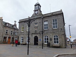
Fraserburgh, locally known as the Broch, is a town in Aberdeenshire, Scotland, with a population recorded in the 2011 Census as 13,100. It lies in Buchan in the northeastern corner of the county, about 40 miles (64 km) north of Aberdeen and 17 miles (27 km) north of Peterhead. It is the biggest shellfish port in Scotland and one of the largest in Europe, landing over 5,450 tonnes in 2016. Fraserburgh is also a major port for white and pelagic fish.

Banffshire is a historic county in Scotland. The county town is Banff, although the largest settlement is Buckie to the west. The historic county ceased to be used for local government purposes in 1975. Since 1996 the area has been split between the Aberdeenshire and Moray council areas. The historic county boundaries of Banffshire are still used for certain functions, being a registration county and lieutenancy area.

Aberdeenshire or the County of Aberdeen is a historic county in Scotland. The county gives its name to the modern Aberdeenshire council area, which covers a larger area than the historic county. The historic county ceased to be used for local government purposes in 1975, but its boundaries are still used for certain functions, being a registration county. The area of the historic county excluding the Aberdeen City council area is also a lieutenancy area.
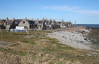
The villages of Inverallochy and Cairnbulg lie some 4 miles (6.4 km) east of Fraserburgh, in North East Scotland. It formerly consisted of the three fishing villages of Brandesburgh, Cairnbulg and Inverallochy, but the former village has since disappeared.
Oldmeldrum is a village and parish in the Formartine area of Aberdeenshire, not far from Inverurie in North East Scotland. With a population of around 2,187, Oldmeldrum falls within Scotland's top 300 centres of population. Oldmeldrum is home to one of the oldest whisky distilleries in Scotland, Glen Garioch, which was built in 1797. Local industries are agriculture and engineering services connected to the oil industry in Aberdeen.
Formartine is a committee area in Aberdeenshire, Scotland. This district extends north from the River Don to the River Ythan. It has a population of 36,478.
Banff is a town in the Banff and Buchan area of Aberdeenshire, Scotland. It is situated on Banff Bay and faces the town of Macduff across the estuary of the River Deveron. It is a former royal burgh, and is the county town of the historic county of Banffshire.

Rattray Head, historically Rattray Point, is a headland in Buchan, Aberdeenshire, on the north-east coast Scotland. To north lies Strathbeg Bay and Rattray Bay is to its south. The dunes at Rattray Head beach can be up to 75 feet (23 m) high and stretch 17 miles (27 km) from St Combs to Peterhead.

Mormond Hill is a broad eminence in Aberdeenshire, Scotland, not far from Fraserburgh. Its twin summits reach heights of 754 feet (230 m) and 767 feet (234 m); the higher of the two is known as Waughton Hill. The hill is surrounded by the low-lying arable region known as Buchan. At its foot are the villages of Strichen and New Leeds.

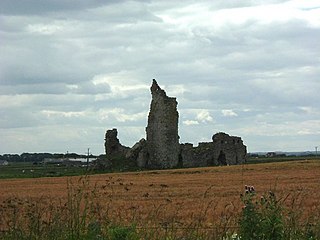
The Castle of Rattray was a medieval Scottish castle, with multiple variations on its structure over approximately six centuries. Originally built as a "late 12th- or early 13th century defensive motte" it provided protection for Starny Keppie Harbour and Rattray village. Sometime between 1214 and 1233 it was upgraded by William Comyn, jure uxoris Earl of Buchan before being destroyed in the 1308 Harrying of Buchan. After Comyn's timber castle was burned down, it was replaced by a stronger stone castle which was engulfed during a 1720 sand storm along with nearby Rattray village. After the storm, the castle was not dug out and remains covered to this day. The castle was described by W. Douglas Simpson as one of the nine castles of the Knuckle, referring to the rocky headland of north-east Aberdeenshire.
The Harrying of Buchan, also known as the Herschip (hardship) or Rape of Buchan, took place in 1308 during the Wars of Scottish Independence. It saw vast areas of Buchan in northeast Scotland, then ruled by Clan Comyn, burned to the ground by Robert the Bruce and his brother Edward, immediately following their success at the Battle of Barra.

St Mary's Chapel is a late 12th/early 13th century chapel found in Rattray, Aberdeenshire, Scotland. It was built by William Comyn, jure uxoris Earl of Buchan during the same period as the Castle of Rattray and was "private chapel for the castle" and its residents. "Dedicated to the Virgin Mary" it was possibly constructed after the "drowning of a"... [unknown] "son of Comyn in the well near by."
The remains of the Castle of Lonmay are found near Netherton of Lonmay, to the north of Loch Strathbeg in Buchan, Scotland. The remains are not located in the modern village of Lonmay which is approximately 6 km to the south-west. It was described by W. Douglas Simpson as one of the nine castles of the Knuckle, referring to the rocky headland of North-East Aberdeenshire.
Dundarg Castle is a ruined castle about 2 kilometres (1.2 mi) north-northeast of New Aberdour, Aberdeenshire, Scotland, built within the ramparts of an earlier Iron Age promontory fort. It was described by W. Douglas Simpson as one of the nine castles of the Knuckle, referring to the rocky headland of North-East Aberdeenshire, and by Charles McKean as "Scotland's answer to Tintagel". It became a small Celtic monastery for a period.
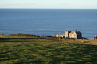
Inverallochy Castle is a ruined courtyard castle, near the village of Inverallochy in the Buchan area of North-East Scotland, dating to 1504. It lies 0.5 miles (0.80 km) south of Cairnbulg Castle, near Fraserburgh, and formerly stood beside the now-drained Loch of Inverallochy. It was described by W. Douglas Simpson as one of the nine castles of the Knuckle, referring to the rocky headland of North-East Aberdeenshire.

Clan Cumming, historically known as Clan Comyn, is a Scottish clan from the central Highlands that played a major role in the history of 13th-century Scotland and in the Wars of Scottish Independence. The Clan Comyn was once the most powerful family in 13th-century Scotland, until they were defeated in civil war by their rival to the Scottish throne, Robert the Bruce.

Barra Castle is an unusual L-plan tower house dating from the early 16th century, about two miles south of Oldmeldrum, above the Lochter Burn, in the parish of Bourtie, Aberdeenshire, Scotland. It occupies the site of the Battle of Inverurie (1308), in which Robert Bruce defeated John Comyn, Earl of Buchan.

Ellon Castle is a scheduled monument within the town of Ellon, Aberdeenshire, Scotland. Only ruins survive of the 16th-century structure that may incorporate sections from the 15th century together with 18th-century renovations. The ruins form a focal point in a formal 6-acre (2.4 ha) garden planted in 1745; an older Category A listed sundial dating from c. 1700 forms the centrepiece to the garden.
The Castle of King Edward is a 13th-century ruined castle near King Edward, Aberdeenshire, Scotland, located 6 kilometres (3.7 mi) north of Turriff, where the A947 crosses the Burn of King Edward, and 2 miles (3.2 km) east of the River Deveron. The castle was the caput of the feudal barony of King Edward.

