Related Research Articles
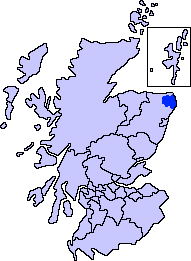
Buchan is one of the six committee areas and administrative areas of Aberdeenshire Council, Scotland. These areas were created by the council in 1996, when the Aberdeenshire council area was created under the Local Government etc (Scotland) Act 1994. The council area was formed by merging three districts of the Grampian Region, Banff and Buchan, Gordon and Kincardine and Deeside. The committee area of Buchan was formed from part of the former district of Banff and Buchan.

Keith Inch is the easternmost point of mainland Scotland. It is located in Peterhead in Aberdeenshire, forming the north point of Peterhead Bay at 57°30′10″N1°45′51″W.

Banff and Buchan is a constituency of the British House of Commons, located in the north-east of Scotland within the Aberdeenshire council area. It elects one Member of Parliament (MP) at least once every five years using the first-past-the-post system of voting.
St Fergus is a village in the Buchan area of Aberdeenshire, Scotland. St Fergus lies a mile from the North Sea coast and three miles north-west of Peterhead. The Parish of St Fergus includes the remains of Inverugie Castle and Ravenscraig Castle. The church in the village was built in 1763. The church for this parish previously stood in the old kirkyard near the shore two miles to the east. This site on the St Fergus Links is still used as a burial ground. Prior to the change in site of the church the parish was known as Longley and at a still more remote period Inverugie.

Peterhead is a town in Aberdeenshire, Scotland. It is Aberdeenshire's biggest settlement, with a population of 18,537 at the 2011 Census.

Maud is a small town in the Buchan area of the Scottish county of Aberdeenshire. Population 780. Located 13 miles west of Peterhead on the South Ugie Water, Maud rose to prosperity in the nineteenth century as a railway junction of the Formartine and Buchan Railway that ran through Maud to Fraserburgh and Peterhead, but has always been the meeting place of six roads. It has had a variety of names:

The Formartine and Buchan Way is a long-distance footpath in Scotland, extending from Dyce north to Peterhead and Fraserburgh in the Buchan and Formartine districts of Aberdeenshire in Scotland. It follows the track of a former railway line, the Formartine and Buchan Railway, and is open to walkers, cyclists and horse riders. The railway closed in 1979 (Fraserburgh) and 1970 (Maud-Peterhead). The walkway opened in the early 1990s, and is managed by Aberdeenshire Council. It is listed as one of Scotland's Great Trails by Scottish Natural Heritage. Places of interest along the way include Drinnes Wood Observatory, Strichen Stone Circle, Aden Country Park, Deer Abbey and The White Horse at Strichen.

Rattray Head, historically Rattray Point, is a headland in Buchan, Aberdeenshire, on the north-east coast Scotland. To north lies Strathbeg Bay and Rattray Bay is to its south. The dunes at Rattray Head beach can be up to 75 feet (23 m) high and stretch 17 miles (27 km) from St Combs to Peterhead.
Lonmay is a village and parish in the Buchan area of Aberdeenshire, Scotland. It lies along the A90 road, between Peterhead and Fraserburgh, near to the junction with the A952 road at Cortes. The parish, formerly known as St Colms, encompasses the villages of St Combs and Crimond, as well as the village of Lonmay. It had a station on the Formartine and Buchan Railway, but this closed in 1965. The present Lonmay Kirk dates from 1786.

Strichen is a village in Aberdeenshire, Scotland. It sits on the A981, connecting it to New Deer 7.2 miles (12 km) to the southwest and Fraserburgh 8 miles (13 km) to the north-northeast, and the B9093, connecting it to New Pitsligo about four miles due west. The village got its name from Lord Strichen. It is situated on the River Ugie at the foothills of Mormond Hill. The Strichen White Horse is constructed of quartz on Mormond Hill, some 1500 m Northeast of Strichen.

New Pitsligo, also known as Cavoch, is a village in Aberdeenshire, Scotland, quite near Peterhead.

HMP Peterhead was a prison in the town of Peterhead in Aberdeenshire, Scotland, operating from 1888 to 2013. Since June 2016 the former grounds operate as the Peterhead Prison Museum.

Hatton is a village in Aberdeenshire, Scotland that lies on the A90 road, approximately equidistant from both Ellon and Peterhead.

Inverugie is a small village in Aberdeenshire, Scotland that lies on the entrance to the River Ugie just north of Peterhead.
Mintlaw railway station was a railway station in Mintlaw, Aberdeenshire.
For the railway station in Adelaide, Australia, see Peterhead railway station, Adelaide.

Cairn Catto is a Neolithic long cairn near Longside, Aberdeenshire, Scotland. The extant monument measures 47.18 by 18.28 metres. The Arbuthnot Museum in Peterhead houses two stone axes that were found at Cairn Catto in 1885.
North East Scotland College was formed on 1 November 2013 from the merger of Aberdeen College and Banff & Buchan College. The regional college serves an extensive geographical area with its main centres in Aberdeen and Fraserburgh.

Stirling Village is a settlement in the Buchan area of Aberdeenshire, Scotland, located on the A90 road immediately to the west of Boddam and 3 miles (4.8 km) south of Peterhead.
Kirktown of St Fergus, often just called Kirktown is an area of the village of St Fergus in Buchan, Aberdeenshire, Scotland. It should not be confused with an area of Peterhead.
References
- ↑ "Downiehills; Peterhead; ABERDEENSHIRE; Scotland". NCAP.org.uk. Retrieved 2020-06-22.
Settlements and places of interest in Buchan, Aberdeenshire | ||
|---|---|---|
| Primary settlements |  | |
| Other settlements | ||
| Places of interest | ||
Coordinates: 57°30′27.9″N1°51′37.5″W / 57.507750°N 1.860417°W
| This Aberdeenshire location article is a stub. You can help Wikipedia by expanding it. |