
Perthshire, officially the County of Perth, is a historic county and registration county in central Scotland. Geographically it extends from Strathmore in the east, to the Pass of Drumochter in the north, Rannoch Moor and Ben Lui in the west, and Aberfoyle in the south; it borders the counties of Inverness-shire and Aberdeenshire to the north, Angus to the east, Fife, Kinross-shire, Clackmannanshire, Stirlingshire and Dunbartonshire to the south and Argyllshire to the west. It was a local government county from 1890 to 1930.
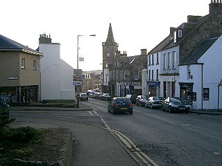
Kinross is a burgh in Perth and Kinross, Scotland, around 13 miles south of Perth and around 20 miles northwest of Edinburgh. It is the traditional county town of the historic county of Kinross-shire.

The County of Kinross or Kinross-shire is a historic county and registration county in eastern Scotland, administered as part of Perth and Kinross since 1930. Surrounding its largest settlement and county town of Kinross, the county borders Perthshire to the north and Fife to the east, south and west.

Loch Leven is a fresh water loch located immediately to the east of the burgh of Kinross in Perth and Kinross council area, central Scotland. Roughly triangular, the loch is about 6 km (3.7 mi) at its longest. Prior to the canalisation of the River Leven, and the partial draining of the loch in 1826–36, Loch Leven was considerably larger. The drop in water level by 1.4 m reduced to the loch to 75% of its former size, and exposed several small islands, as well as greatly increasing the size of the existing ones.

Ben Lomond, 974 metres (3,196 ft), is a mountain in the Scottish Highlands. Situated on the eastern shore of Loch Lomond, it is the most southerly of the Munros. Ben Lomond lies within the Ben Lomond National Memorial Park and the Loch Lomond and The Trossachs National Park, property of the National Trust for Scotland.
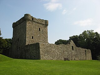
Loch Leven Castle is a ruined castle on an island in Loch Leven, in the Perth and Kinross local authority area of Scotland. Possibly built around 1300, the castle was the location of military action during the Wars of Scottish Independence (1296–1357). In the latter part of the 14th century, the castle was granted by his uncle to William Douglas, 1st Earl of Douglas, and remained in the Douglases' hands for the next 300 years. Mary, Queen of Scots was imprisoned here in 1567–68, and forced to abdicate as queen, before escaping with the help of her gaoler's family. In 1588, the Queen's gaoler inherited the title Earl of Morton, and moved away from the castle. It was bought, in 1675, by Sir William Bruce, who used the castle as a focal point in his garden; it was never again used as a residence.

Milnathort is a small town in the parish of Orwell in the historic county of Kinross-shire, Scotland and the local government (Council) area of Perth and Kinross. The smaller neighbour of nearby Kinross, Milnathort has a population of around 2,000 people. It is situated amidst picturesque countryside at the foot of the Ochil Hills, and near the north shore of Loch Leven. From 1977 it became more easily accessible due to the development of the M90 motorway. The name comes from the Gaelic maol coirthe meaning "bare hill of the standing stones".
Leven is a seaside town in Fife, set in the east Central Lowlands of Scotland. It lies on the coast of the Firth of Forth at the mouth of the River Leven, 8.1 miles (13.0 km) north-east of the town of Kirkcaldy and 6.4 miles (10.3 km) east of Glenrothes.

Schiehallion is a prominent mountain in Perth and Kinross, Scotland. Schiehallion has a rich botanical life, interesting archaeology, and a unique place in scientific history for an 18th-century experiment in "weighing the world". The mountain's popularity amongst walkers led to erosion on its footpath and extensive repairs were undertaken in 2001.

Markinch (, is both a village and a parish in the heart of Fife, Scotland. According to an estimate taken in 2008, the village has a population of 2,420. The civil parish had a population of 16,530. Markinch is east of Fife's administrative centre, Glenrothes and preceded Cupar as Fife's place of warranty and justice prior to the 13th century.

The Kingdom Caledonian Amateur Football Association (KCAFA) was a football (soccer) league competition for amateur clubs in the Fife area of Scotland. It was formed in 1984 when the top sides from the East Fife A.F.A. and the Kirkcaldy & District A. F. L. broke away and amalgamated with the aim of creating a highly competitive league with fewer games in an effort to raise the quality and the profile of amateur football in Fife. The association was affiliated to the Scottish Amateur Football Association.
Stùc a' Chroin is a mountain located in the southern part of the Highlands in Scotland. It lies to the south of Ben Vorlich, which is itself bounded to the north by Loch Earn, and to the west by Loch Lubnaig. The boundary between the council areas of Perth and Kinross and Stirling passes through the summit of the peak, and the town of Callander lies to the south.

The Lomond Hills, also known outwith the locality as the Paps of Fife, are a range of hills in central Scotland. They lie in western central Fife and Perth and Kinross, Scotland. At 522 metres (1,713 ft) West Lomond is the highest point in the county of Fife.
Ballingry ; Scots: Ballingry, Bingry, Scottish Gaelic: Baile Iongrach) is a small town in Fife, Scotland. It is near the boundary with Perth and Kinross, north of Lochgelly. It has an estimated population (2016) of 5,740. The once separate villages of Ballingry, Lochore, Crosshill, and Glencraig are now somewhat joined together as the part of the Benarty area. Ballingry, along with its neighbour Lochgelly, is one of Fife's 'regeneration areas' and is classed as in need of regeneration economically and socially.

The Cateran Trail is a 103-kilometre (64 mi) circular long-distance walking route in central Scotland. The trail has no official beginning or end and can be joined at any stage. The route was established, way-marked and is now maintained by, the Perth & Kinross Countryside Trust. A variety of terrain is covered by the trail including farmland, mountains and forest. The path itself follows old drovers' roads, minor paved roads and farm tracks and can be walked in 4 or 5 days. It is now designated as one of Scotland's Great Trails by NatureScot. As of 2018 it was estimated that around 8,000 people were using the trail each year.

Portmoak is a parish in Kinross-shire, Scotland. It consists of a group of settlements running north to south they are Glenlomond, Wester Balgedie, Easter Balgedie, Kinnesswood, Kilmagadwood and Scotlandwell.

Kinnesswood, possibly from the Scottish Gaelic: Ceann eas ciad is a village in Perth and Kinross, Scotland. It lies to the east of Loch Leven, on the A911 road, below Bishop Hill in the Lomond Hills. It is approximately 4 miles west of Glenrothes and 4 miles east of Kinross.
The Railways of Kinross were a local network of three rural railways which made the town of Kinross in Scotland their objective in the 1859s.


