
Inchcruin is an island in Loch Lomond in Scotland. It is not to be confused with Creinch, which has occasionally been referred to as "Inchcroin".
Inchcruin is an island in Loch Lomond in Scotland. It is not to be confused with Creinch, which has occasionally been referred to as "Inchcroin".
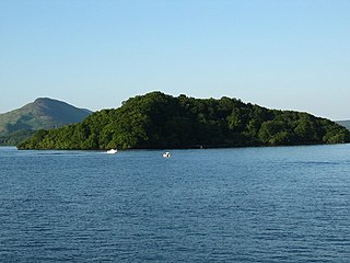
Inchcruin is one of an island group just south of Luss. It is 3⁄4 mile (1.2 kilometres) long, and 50 feet (15 metres) in elevation at its highest point. [1] Its name means "round island" in the Scottish Gaelic language, although it is not round, but a rather jagged shape. [2] It has a couple of beaches, and is wooded, with some open fields. [1]
Only a very narrow channel, called the Geggles separates Inchcruin from Inchmoan. At only 3–4 ft (90–120 cm) deep, it is sometimes possible to wade between the islands. [3] [4]
The travel writer, H.V. Morton visited Loch Lomond in the 1930s, and mentions Inchcruin briefly and wrongly as "Inchcruim". [5]
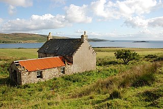
In the 18th century it was used as an asylum for the insane. [6] It contains one house, around 200 years old, which was inhabited in the past by people who farmed on the island. It is now a holiday retreat.
The island is classified by the National Records of Scotland as an inhabited island that "had no usual residents at the time of either the 2001 or 2011 censuses." [7] [8]

Loch Lomond is a freshwater Scottish loch which crosses the Highland Boundary Fault, often considered the boundary between the lowlands of Central Scotland and the Highlands. Traditionally forming part of the boundary between the counties of Stirlingshire and Dunbartonshire, Loch Lomond is split between the council areas of Stirling, Argyll and Bute and West Dunbartonshire. Its southern shores are about 23 kilometres (14 mi) northwest of the centre of Glasgow, Scotland's largest city. The Loch forms part of the Loch Lomond and The Trossachs National Park which was established in 2002.

Inch Kenneth is a small grassy island off the west coast of the Isle of Mull, in Scotland. It is at the entrance of Loch na Keal, to the south of Ulva. It is part of the Loch na Keal National Scenic Area, one of 40 in Scotland. It is within the parish of Kilfinichen and Kilvickeon, in Argyll and Bute.
Inchmurrin is an island in Loch Lomond in Scotland. It is the largest fresh water island in the British Isles.

Inchconnachan is an island in Loch Lomond in Scotland, in the Trossachs National Park. It is accessible by boat from the village of Luss on the south side of the Loch.

Inchcailloch is an islet on Loch Lomond in Scotland. It is 85 metres (279 ft) at its highest point. It is also known to some as Inchebroida.

Oronsay is an uninhabited island in Loch Sunart, Scotland.
The Island of Danna or Danna, is an inhabited tidal island in Argyll and Bute.

Inchfad is an island in the south east of Loch Lomond in Scotland.

Soay Mòr is an island in West Loch Tarbert, between the northern and southern parts of Harris. The uninhabited island is separated from the southwest coast of North Harris by the Soay Sound. The adjacent Soay Beag is accessible on foot at low tide.

Inchmoan is an island in Loch Lomond, Scotland.

Inchlonaig is an island in Loch Lomond in Scotland.
Inchtavannach, is one of the larger islands in Loch Lomond.

Moncreiffe Island, also known as Friarton Island, is an island in Perth, Scotland. It divides the River Tay into two channels as it flows through Perth, and is crossed by the single-track Tay Viaduct, carrying the Scottish Central Railway.
Creinch is an island on the Highland boundary fault in Loch Lomond.

Bucinch or Buc-Innis is a small island in Loch Lomond, in west central Scotland.

Clairinsh or Clairinch is an island in Loch Lomond, central Scotland.

Eilean Loain is a small island in Loch Sween and one of the Inner Hebrides of Scotland.

Eilean dà Mhèinn, is a small inhabited island in Loch Crinan and one of the Inner Hebrides of Scotland.
| Wikimedia Commons has media related to Inchcruin . |
Coordinates: 56°5′11″N4°35′44″W / 56.08639°N 4.59556°W
| | This Stirling location article is a stub. You can help Wikipedia by expanding it. |