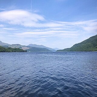
Inchmurrin is the largest and most southerly of the islands in Loch Lomond. It reaches a height of 89 metres (292ft) towards the north and is largely wooded.[6] There is an excellent view of the north end of the loch.[7]
Inchmurrin was the site of a 7th-century monastery, with a chapel dedicated to Saint Mirin, after whom it was named.
The island was formerly a deer park of the Dukes of Montrose, who had a hunting lodge built in 1793 and maintained a gamekeeper and his family there.[8] 200 deer are recorded in 1800.[9] There are ruins of a castle, probably built for Duncan, 8th Earl of Lennox whose seat was Balloch Castle at the south end of Loch Lomond.[5] The castle was probably a hunting lodge for the deer park established on the island by King Robert I of Scotland in the early 14th century.[10] After her husband Murdoch Stewart, Duke of Albany, father Donnchadh, Earl of Lennox, and two sons were executed by James I in 1425, Isabella Countess of Lennox retired to the castle on Inchmurrin with her grandchildren.[7]
A map from the 1800s showing the islands of Loch Lomond.
A French ambassador, Monsieur de Béthune, brother of the Duke of Sully, came in July 1599 and went on a hunting progress with James VI from Falkland Palace to Inchmurrin and Hamilton Palace.[13] In 1617 King James made his only return visit to Scotland, and included Inchmurrin in his itinerary to go hunting. The Duke of Lennox wrote to the custodian of the island on 23 July 1617, asking for food to be prepared for "a good nombre of sharpe stomaches", probably a reference to the hunting trip.[7]
Rob Roy raided the island. At one point, his men came to control all the boats on the River Endrick and Loch Lomond, which were later used to remove cattle from Inchmurrin.[5]
Inchmurrin was used as a mental asylum, and also unmarried pregnant women were sent here to give birth.[5]
The English travel writer, H.V. Morton visited Inchmurrin in the 1930s and described it as "the grassy isle, an island packed with memories."[7]
The island has been owned by the Scott family for over 70 years. They farm it and run self-catering apartments, a cottage, and restaurant.[14] They used to have a sign at the jetty saying, "You are now entering Scott Country".[5]
The World Record for haggis hurling was held by Alan Pettigrew for over 20 years. He threw a 1lb 8oz (680g)haggis180ft 10in (55.12m) on Inchmurrin in August 1984. However this was beaten when a new record was set at 217ft (66m) by Lorne Coltart at the Milngavie Highland Games on 11 June 2011.[15]
Facilities
As well as offering self catered accommodation in the form of 3 flats and an 8-person cottage, the island has its own bar and restaurant, open from Easter to October. Inchmurrin is licensed to hold civil ceremonies.
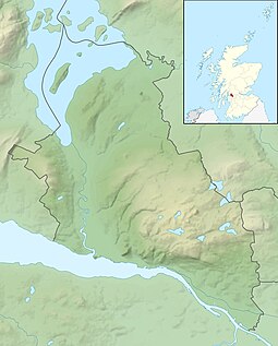
Loch Lomond is a freshwater Scottish loch which crosses the Highland Boundary Fault, often considered the boundary between the lowlands of Central Scotland and the Highlands. Traditionally forming part of the boundary between the counties of Stirlingshire and Dunbartonshire, Loch Lomond is split between the council areas of Stirling, Argyll and Bute and West Dunbartonshire. Its southern shores are about 23 kilometres (14 mi) northwest of the centre of Glasgow, Scotland's largest city. The Loch forms part of the Loch Lomond and The Trossachs National Park which was established in 2002.
Dunbartonshire or the County of Dumbarton is a historic county, lieutenancy area and registration county in the west central Lowlands of Scotland lying to the north of the River Clyde. Dunbartonshire borders Perthshire to the north, Stirlingshire to the east, Lanarkshire and Renfrewshire to the south, and Argyllshire to the west.
Loch Lomond and The Trossachs National Park is a national park in Scotland centred on Loch Lomond and the hills and glens of the Trossachs, along with several other ranges of hills. It was the first of the two national parks established by the Scottish Parliament in 2002, the second being the Cairngorms National Park. The park extends to cover much of the western part of the southern highlands, lying to the north of the Glasgow conurbation, and contains many mountains and lochs. It is the fourth-largest national park in the British Isles, with a total area of 1,865 km2 (720 sq mi) and a boundary of some 350 km (220 mi) in length. It features 21 Munros and 20 Corbetts.
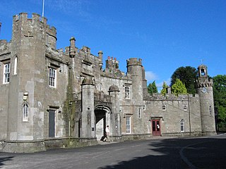
Balloch Castle is an early 19th-century country house situated at the southern tip of Loch Lomond, in West Dunbartonshire, Scotland. Balloch was a property of the Lennox family from the 11th century, and the old castle was built in the 13th century. In the 19th century the estate was purchased by John Buchanan of Ardoch, who demolished the ruins of the old castle and erected the present building. The Tudor Gothic architecture is the work of Robert Lugar. In 1915 Balloch was bought by Glasgow City Corporation, and has been leased by West Dunbartonshire Council since 1975. The estate was designated as a country park in 1980, and since 2002 has been part of Loch Lomond and The Trossachs National Park. Although the house has been periodically used for visitor facilities and council offices, it is now included on the Buildings at Risk Register. Balloch Castle is a category A listed building, and the estate is included on the Inventory of Gardens and Designed Landscapes in Scotland.
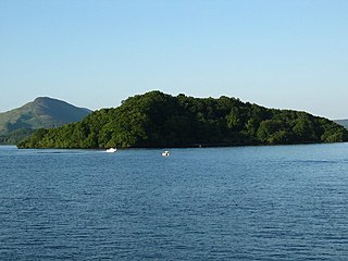
Inchconnachan is an island in Loch Lomond in Scotland, in the Trossachs National Park. It is accessible by boat from the village of Luss on the south side of the Loch.
Clan Colquhoun is a Highland Scottish clan.
Clan MacFarlane is a Highland Scottish clan. Descended from the medieval Earls of Lennox, the MacFarlanes occupied the land forming the western shore of Loch Lomond from Tarbet up-wards. From Loch Sloy, a small sheet of water near the foot of Ben Vorlich, they took their war cry of Loch Slòigh.
Clan Galbraith is a Scottish clan. The clan does not have a chief recognised by the Lord Lyon King of Arms. Because of this, the clan is considered an armigerous clan, and as such Clan Galbraith has no standing under Scots Law. The clan-name of Galbraith is of Gaelic origin, however its meaning denotes the bearer as of Brythonic origin, as opposed to Gaelic. The early Galbraiths were centred in the Lennox district, which spans the Highland and Lowland border of Scotland. The 17th chief of the clan brought ruin to the clan in the late 16th and early 17th century, and eventually lost his lands and fled Scotland for Ireland. His grandson, the 19th chief, was the last chief of Clan Galbraith.
Inchcailloch is an islet on Loch Lomond in Scotland. It is 85 metres (279 ft) at its highest point. It is also known to some as Inchebroida.
Inchfad is an island in the south east of Loch Lomond in Scotland.
Inchmoan is an island in Loch Lomond, Scotland.
Inchlonaig is an island in Loch Lomond in Scotland.
Inchtavannach, is one of the larger islands in Loch Lomond.
Loch Lomond Golf Club is located in Luss, Argyll & Bute, Scotland on the shore of Loch Lomond. The course occupies land previously held by Clan Colquhoun and includes the clan's seat of Rossdhu House as its clubhouse.
Inchgalbraith is an islet in Loch Lomond, Scotland, and is the ancestral home of Clan Galbraith.
Creinch is an island on the Highland Boundary Fault in Loch Lomond.
Clairinsh or Clairinch is an island in Loch Lomond, central Scotland.
Fraoch Eilean is a small island in Loch Lomond, Scotland. Its name means "heather island" in Scottish Gaelic.
Pier Road is a street in Luss, Argyll and Bute, Scotland. Located on Loch Lomond's western shore, the road, which is on an east–west alignment, consists of around twenty buildings, many of which are listed cottages dating from the 19th century.
This page is based on this Wikipedia article Text is available under the CC BY-SA 4.0 license; additional terms may apply. Images, videos and audio are available under their respective licenses.