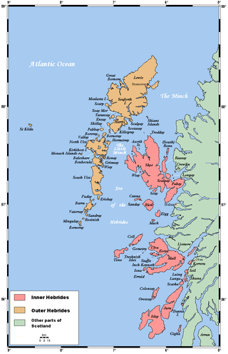
The Hebrides are an archipelago off the west coast of the Scottish mainland. The islands fall into two main groups, based on their proximity to the mainland: the Inner and Outer Hebrides.
The Outer Hebrides or Western Isles, sometimes known as the Long Isle or Long Island, is an island chain off the west coast of mainland Scotland. The islands form part of the archipelago of the Hebrides, separated from the Scottish mainland and from the Inner Hebrides by the waters of the Minch, the Little Minch, and the Sea of the Hebrides. The Outer Hebrides are considered to be the traditional heartland of the Gaelic language. The islands form one of the 32 council areas of Scotland, which since 1998 has used only the Gaelic form of its name, including in English language contexts. The council area is called Na h-Eileanan an Iar and its council is Comhairle nan Eilean Siar.
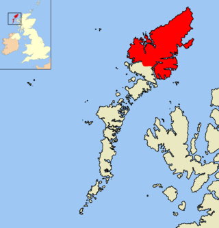
The Isle of Lewis or simply Lewis is the northern part of Lewis and Harris, the largest island of the Western Isles or Outer Hebrides archipelago in Scotland. The two parts are frequently referred to as if they were separate islands. The total area of Lewis is 683 square miles (1,770 km2).

Harris is the southern and more mountainous part of Lewis and Harris, the largest island in the Outer Hebrides, Scotland. Although not an island itself, Harris is often referred to in opposition to the Isle of Lewis as the Isle of Harris, which is the former postal county and the current post town for Royal Mail postcodes starting HS3 or HS5.
Lismore is an island of some 2,351 hectares in the Inner Hebrides of Scotland. The climate is damp and mild, with over 166 centimetres (65 in) of rain recorded annually. This fertile, low-lying island was once a major centre of Celtic Christianity, with a 6th-century monastery associated with Saint Moluag, and later became the seat of the medieval Bishop of Argyll. There are numerous ruined structures, including a broch and two 13th-century castles.
Scalpay is an island in the Outer Hebrides of Scotland.
Great Bernera, often known just as Bernera, is an island and community in the Outer Hebrides of Scotland. With an area of just over 21 square kilometres, it is the thirty-fourth largest Scottish island.
Berneray is an island and community in the Sound of Harris, Scotland. It is one of fifteen inhabited islands in the Outer Hebrides. It is famed for its rich and colourful history which has attracted much tourism. It lies within the South Lewis, Harris and North Uist National Scenic Area, one of 40 such areas in Scotland which are defined so as to identify areas of exceptional scenery and to ensure its protection from inappropriate development.

Clan MacLeod is a Highland Scottish clan associated with the Isle of Skye. There are two main branches of the clan: the MacLeods of Harris and Dunvegan, known in Gaelic as Sìol Tormoid and the Clan MacLeod of Lewis Assynt and Raasay, known in Gaelic as Sìol Torcaill. Both branches claim descent from Leòd, a Norse-Gael who lived in the 13th century.
Loch Morar is a freshwater loch in the Rough Bounds of Lochaber, Highland, Scotland. It is the fifth-largest loch by surface area in Scotland, at 26.7 km2 (10.3 sq mi), and the deepest freshwater body in the British Isles with a maximum depth of 310 m (1,017 ft). The loch was created by glacial action around 10,000 years ago, and has a surface elevation of 9 metres (30 ft) above sea level. It separates the traditional district of North Morar, from Arisaig and Moidart.

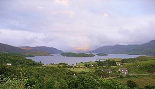
Uig, also known as Sgìr' Ùig, is a civil parish and community in the west of the Isle of Lewis in the Outer Hebrides, Scotland. The Parish of Uig is one of the four civil parishes of the Isle of Lewis. It contains the districts of Carloway, East Uig, Bernera and West Uig. The name derives from the Norse word Vik meaning 'a bay'.

Loch Assynt is a freshwater loch in Sutherland, Scotland, 8 kilometres (5.0 mi) north-east of Lochinver.
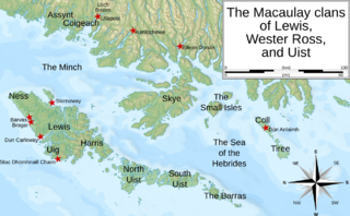
The Macaulay family of Uig in Lewis, known in Scottish Gaelic as Clann mhic Amhlaigh, were a small family located around Uig on the Isle of Lewis in the Outer Hebrides of Scotland. There is no connection between the Macaulays of Lewis and Clan MacAulay which was centred in the Loch Lomond area, bordering the Scottish Highlands and Scottish Lowlands. The Macaulays of Lewis are generally said to be of Norse origin because of the etymology of their surname and also because of the islands' Viking Age past. However, a recent analysis of the Y-DNA of men with Scottish surnames has shown that a large number of Hebridean Macaulays are of Irish origin. In the 17th century, however, tradition gave the Macaulays an Irish origin. By the end of the 16th century the dominant clan on Lewis was Clan Macleod of The Lewes. Other notable Lewis clans were the somewhat smaller Morrisons of Ness and the even less numerous Macaulays of Uig. The Macaulays were centred in the area surrounding Uig on the western coast of Lewis, and had a deadly, long-standing feud with the Morrisons, whose lands were located on the northern coast around Ness. Today the Lewis surname Macaulay is considered to be a sept name of the Macleods of Lewis. There are two other nearby clans of Macaulays who may, or may not, be connected to the Lewis clan—the Wester Ross Macaulays, and the Uist MacAulays.

Lewis and Harris, or Lewis with Harris, is a Scottish island in the Outer Hebrides, around 24 miles (39 km) from the Scottish mainland.
Dùn Anlaimh, also known as Dùn Amhlaidh, and Eilean nan Cinneachan, is a crannog, located within Loch nan Cinneachan on the Inner Hebridean island of Coll. Upon the crannog there are the remains of walls and several buildings. These remains are not unlike those of other fortified islands found throughout the Outer Hebrides, and it is likely that Dùn Anlaimh dates from the late Middle Ages. According to local tradition on Coll, the fort was once the home of a Norse chieftain who was defeated in battle somewhere nearby. The early 20th century antiquary Erskine Beveridge considered it as one of the four most interesting fortifications, on Coll. The site of Dùn Anlaimh is located at grid reference NM18845684. The RCAHMS classifies the site as a 'crannog' and an 'island dwelling'.

Duirinish is a peninsula and civil parish on the island of Skye in Scotland. It is situated in the north west between Loch Dunvegan and Loch Bracadale.

Dùn Beic is a dun located on the Inner Hebridean island of Coll. It is located at grid reference NM15495644 and is thought to date to between 1000 BCE to 1000 CE. The etymology of the dun's name is uncertain; one possibility is that it could be made up of a personal name. The dun appears in local legend as being one of several fortresses held by Norsemen, who were defeated in battle against the ancestor of the Macleans of Coll. There have been several archaeological finds at Dùn Beic; these include pieces of flint, burnt bone, and fragments of incised pottery.

Loch Sgadabhagh or Loch Scadavay is a body of water on the island of North Uist, Scotland. The name may be of Old Norse derivation meaning "lake of tax bay" although if so, the reason is obscure. Loch Sgadabhagh is the largest loch by area on North Uist although Loch Obisary has about twice the volume.
