
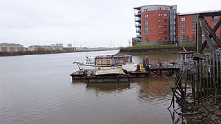
The River Clyde is a river that flows into the Firth of Clyde, in the west of Scotland. It is the ninth-longest river in the United Kingdom, and the third longest in Scotland after the River Tay and the River Spey. It runs through the city of Glasgow. The River Clyde estuary has an upper tidal limit located at the tidal weir next to Glasgow Green.
Govan is a district, parish, and former burgh now part of southwest Glasgow, Scotland. It is situated 2+1⁄2 miles west of Glasgow city centre, on the south bank of the River Clyde, opposite the mouth of the River Kelvin and the district of Partick. Historically it was part of the County of Lanark.

Scotstoun is an area of Glasgow, Scotland, west of Glasgow City Centre. It is bounded by Garscadden and Yoker to the west, Victoria Park, Jordanhill and Whiteinch to the east, Jordanhill to the north and the River Clyde to the south. At the heart of Scotstoun lies Scotstounhill, an enclave of late Victorian and post-war housing centred on Scotstounhill railway station. Scotstoun is home to BAE Systems Surface Ships, and to the Glasgow Warriors rugby team.

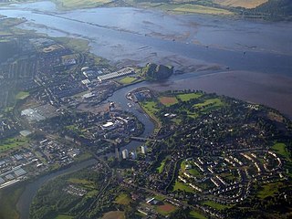
Inchinnan is a small village in Renfrewshire, Scotland. The village is located on the main A8 road between Renfrew and Greenock, just south east of the town of Erskine.

The River Cart is a tributary of the River Clyde, Scotland, which it joins from the west roughly midway between the towns of Erskine and Renfrew and opposite the town of Clydebank.

Whiteinch is an area in the city of Glasgow, Scotland. It is situated directly north of the River Clyde, between the Partick and Scotstoun areas of the city. Whiteinch was at one stage part of the burgh of Partick, until that burgh's absorption into the expanding city of Glasgow in 1912, and part of the Parish of Govan.

Shieldhall is a district in the Scottish city of Glasgow. It is situated directly south of the River Clyde and is part of the wider Govan area.

Renfrewshire or the County of Renfrew is a historic county, registration county and lieutenancy area in the west central Lowlands of Scotland. The lieutenancy area covers the three modern council areas of Inverclyde, Renfrewshire and East Renfrewshire, and this area is occasionally termed Greater Renfrewshire to distinguish it from the modern council area called Renfrewshire. The historic county additionally included territory on the south-western edge of Glasgow which was gradually transferred to the administrative area of the city as it grew.
This article deals with the history of the Partick area of Glasgow in Scotland.

The 1877–78 Scottish Cup – officially the Scottish Football Association Challenge Cup – was the fifth season of Scotland's most prestigious football knockout competition. For the first time, over 100 teams took part in the competition which began with the first round on 22 September 1877. The cup was won by Vale of Leven for a second time after they defeated Glasgow club 3rd Lanark RV 1–0 in the final on 30 March 1878.

Renfrew is a town 6 miles (10 km) west of Glasgow in the west central Lowlands of Scotland. It is the historic county town of Renfrewshire. Called the "Cradle of the Royal Stewarts" for its early link with Scotland's former royal house, Renfrew gained royal burgh status in 1397.

Erskine Ferry sailed across the River Clyde from Erskine to Old Kilpatrick. The ferry was also referred to as East Ferry of Erskine as there was another ferry to Dumbarton a few miles down river, known as West Ferry. It is reputed to be the oldest ferry crossing of the Clyde. The crossing was part of the A740 route from Paisley to Old Kilpatrick. It was established in 1777 and replaced by the Erskine Bridge in 1971.

Bodinbo Island is an islet in the estuarine waters of the River Clyde close to the old ferry slipway at Erskine. Before the dyke or training wall was built the rocky Bodinbo Island was a prominent feature in the river hereabouts and a hazard to shipping, especially sailing craft in the dark, during foggy weather, flood conditions and in high winds. On Ordnance Survey maps the name has been transliterated to Bottombow Island and Boden Boo is the spelling variant used for the nearby woodland plantation.

The disused Park Quay or Fulton's Quay is located on the old Lands of Park, situated on the south bank of the River Clyde in the Parish of Inchinnan, close to Newshot Island and the old Rashielee Quay. A slipway is also part of the infrastructure, giving access to the dock at low tide, both once served by roads running through the Park Estate from the south. It was recorded as Fulton's Quay in 1830, the name of a previous owner of the Park Estate who may have built it prior to 1801. A fixed light was installed at Park Quay in 1869.
Milton Island or Green Inch was an island in the Clyde's estuarine waters close to the old ford across the river at Dumbuck near Dumbarton. The island was once part of the tidal ford supposedly built by the Romans. Industrial activity has changed the river currents and the island has become substantially reduced in size and split into islets.

The old Rashielee Quay or Rashielie Quay (NS471709) was located on the old Lands of North Barr, situated on the south bank of the River Clyde in the Parish of Inchinnan, between Bodinbo Island and Park Quay. It was built to facilitate the loading of boats and barges with whinstone excavated from the nearby Rashielee Quarries that was brought to the quay by a horse drawn wagonway.

Newshot Island or Newshot Isle was an island about 50 acres (20 ha) in extent lying in the estuarine waters of the River Clyde close to Park Quay in the Parish of Inchinnan, Renfrewshire, Scotland. Due to silting, etc. it has become part of the southern, Renfrewshire side, of the river bank and is used for grazing cattle and as a nature reserve.
Inchview was a football ground in the Whiteinch area of Glasgow, Scotland. It was the home ground of Partick from the 1870s until 1885, and of Partick Thistle from 1885 until 1897.
King's Inch and the much smaller Sand Inch were islands lying in the estuarine waters of the River Clyde close to Renfrew in Renfrewshire, Scotland. Due to dredging and a change of the course of the main current of the River Clyde, silting, etc. it has become part of the southern, Renfrewshire side, of the river bank and is now built over.


