Newshot Island

Last updated

Newshot Island
The River Clyde from the air (geograph 5580539).jpg
Newshot Island from the air
Location
Renfrewshire UK relief location map.jpg
Red pog.svg
Newshot Island
Relief maps of Newshot Island
West Dunbartonshire UK relief location map.jpg
Red pog.svg
Newshot Island
Newshot Island (West Dunbartonshire)
Scotland relief location map.jpg
Red pog.svg
Newshot Island
Newshot Island (Scotland)
OS grid reference NS48757011
Coordinates 55°54′01″N4°25′14″W / 55.9003°N 4.42068°W / 55.9003; -4.42068
Physical geography
Island groupIslands of the River Clyde
Areac.3ha
Highest elevation<3 metres (9.8 ft)
Administration
Sovereign state United Kingdom
Country Scotland
Council area Renfrewshire
Demographics
Population0
Lymphad3.svg

Newshot Island or Newshot Isle was an island of circa 50 acres or 20 hectares lying in the estuarine waters of the River Clyde close to Park Quay in the Parish of Inchinnan, Renfrewshire, Scotland. Due to silting, etc. it has become part of the southern, Renfrewshire side, of the river bank and is used for grazing cattle and as a nature reserve.

Contents

The Scots word 'shot' or its spelling variants was an ancient unit for a division of land or alternatively a projecting area of land, a peninsula. [1] A 'Shot' also has the meaning of a place where fishing-nets were generally used and, in salmon fishing terminology, a part of the river from which nets were cast. [1]

Islands in the River Clyde

Islands of the River Clyde, rather than sand or mud banks only exposed at low water, once included in order, working upstream towards Glasgow :- Milton, Bodinbo, Newshot, Ron, Sand Inch, Kings Inch, Buck Inch, White Inch and Water Inch. A Colin's Isle once sat in the waters of the Cart near its confluence with the River Clyde. [2]

The name 'Inch' is Scots deriving from the Gaelic 'Innis', an island. [3] The name 'Ron' in Scots refers to a thicket of hawthorns or rose briers, an area of stunted and crowded woodland. [4]

Newshot Island

Newshot Island from Park Quay Park Quay and Newshot Island, River Clyde, Erskine.jpg
Newshot Island from Park Quay

The Palace or Castle of Inchinnan was built circa 1506 by the Darnley family. Largely still standing in 1710, it had been completely demolished by the end of the 18th century and some of its stones used in the construction of a wall built on Newshot Island. [5] In 1745 the lands of Inchinnan, its mill and the Newshots Isles 'within the Floodmark' were granted to James Campbell of Blythswood. [6]

Reed beds at Newshot Island. Reeds at Newshot Island, River Clyde - geograph.org.uk - 1733842.jpg
Reed beds at Newshot Island.

The farm of Garnieland, now demolished, stood near the old Palace of Inchinnan and included the lands and isles of Newshot. [7] [8]

Timothy Pont's early 17th century map clearly shows a single 'Neushot' island [9] and by the mid-17th century 'New-Shot' is recorded close to Ron island and opposite Inchinnen Castle. [10] In 1800 the island is recorded as 'Nushet'. [11] The name is 'Newshot' is used by 1832. [12]

Newshot Island and Erskine Bridge The River Clyde from the air (geograph 5580538).jpg
Newshot Island and Erskine Bridge
fields beside Newshot Island Erskine from the air (geograph 4542697).jpg
fields beside Newshot Island
Erskine sewage works and Newshot Island Erskine sewage works from the air (geograph 5221058).jpg
Erskine sewage works and Newshot Island

Some maps show an islet lying on the south-western side of the main island. [13] [14] [15] By 1896 this islet had joined with the south bank. [16]

A beacon or marker indicating the southernmost limit of the Clyde's deep-water channel existed in 1846 chart of the river but was absent by 1864. [17]

The OS Name Book of 1856-1857 records Newshot Island as "An extensive and very remarkable tract of land following the course of the River Clyde about 1½ miles. On the south side, it is bounded by the "Old Channel", or former course of the above, tapering at both extremeties. The surface is quite flat, and, excepting the part covered at "High Water," may be regarded as very good pasture land." [18]

A number of maps from 1800 show a small building on the island [8] [19] [20] and at one time apparent cultivation [21] and hedgerows or dykes. [22] A small raised area on the isle may represent the location of the building. The first direct connection to the Garnieland Farm was a causeway or bridge built towards the upstream end of the isle in 1800 [23] [12] and later in the 19th century a second causeway was built, centred at (NS481702). [24]

These causeways may have interfered with the water flow to the extent that silt deposits built up and eventually by 1896 the upstream section of the island became physically land linked to the southern bank. [16] The old river channel thus became silted up whilst the new channel became deep enough for large ships to reach Glasgow. [25] The old river channel also appears to have been used as a site for the mud punts to dispose of the dredgings from the docks at Glasgow. [26]

The island has a possible fishing weir remnant built across the inner lagoon. [27] [28]

A WWII barrage balloon mooring anchor was located on the island. [29]

Ship graveyard

The Newshot Island site is a scheduled monument that includes wrecks of mud punts and a diving support vessel. Twenty-eight punts are located here and a circa 1852 iron hulled dive support vessel. Immediately adjacent to the diving support vessel is a square structure. The surrounding dredged material may contain objects dredged from the River Clyde associated with the maintenance linked to the deepening of the River Clyde's navigation channels. [26]

The Queen Mary

The RMS Queen Mary briefly grounded on Newshot Isle on her journey down the Clyde after her launch on 24 March 1936. [30]

Wildlife

James Watt's 1736 survey of the River Clyde. James Watt's survey of the River Clyde.jpg
James Watt's 1736 survey of the River Clyde.

The Newshot Local Nature Reserve is a 73-hectare site that is valuable for its salt-marshes and as a feeding and nesting site for a migratory birds from North America, Siberia and West Africa.[ citation needed ]

See also

Related Research Articles

Renfrewshire Council area of Scotland

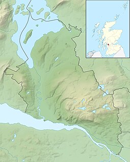
Renfrewshire is one of the 32 council areas of Scotland.

Braehead Shopping mall in Renfrewshire, Scotland

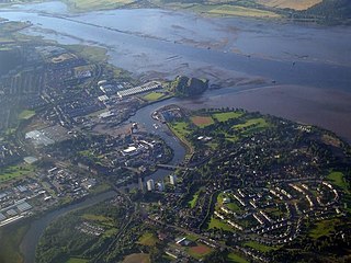
Braehead is a commercial development located at the former site of Braehead Power Station in Renfrew on the south bank of the River Clyde in Renfrew, Renfrewshire. It is particularly notable for its large shopping centre, arena and leisure facilities.

Erskine Post town in Renfrewshire, Scotland

Erskine is a town in the council area of Renfrewshire, and historic county of the same name, situated in the West Central Lowlands of Scotland. It lies on the southern bank of the River Clyde, providing the lowest crossing to the north bank of the river at the Erskine Bridge, connecting the town to Old Kilpatrick in West Dunbartonshire. Erskine is a commuter town at the western extent of the Greater Glasgow conurbation, bordering Bishopton to the west and Renfrew, Inchinnan, Paisley and Glasgow Airport to the south. Originally a small village settlement, the town has expanded since the 1960s as the site of development as an overspill town, boosting the population to over 15,000. In 2014, it was rated one of the most attractive postcode areas to live in Scotland.

Inchinnan Human settlement in Scotland

Inchinnan is a small village in Renfrewshire, Scotland. The village is located on the main A8 road between Renfrew and Greenock, just south east of the town of Erskine.

Wemyss Bay Human settlement in Scotland

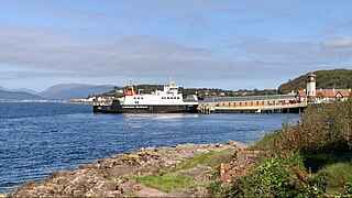
Wemyss Bay is a village on the coast of the Firth of Clyde in Inverclyde in the west central Lowlands of Scotland. It is in the traditional county of Renfrewshire. It is adjacent to Skelmorlie, North Ayrshire. The villages have always been in separate counties, divided by the Kelly Burn.

River Cart

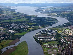
The River Cart is a tributary of the River Clyde, Scotland, which it joins from the west roughly midway between the towns of Erskine and Renfrew and opposite the town of Clydebank.

Lyle Hill Greenock, Inverclyde, Scotland

Lyle Hill at the West End of Greenock, Inverclyde, Scotland, has scenic viewpoints accessible from Lyle Road which was constructed in 1879–1880 and named after Provost Abram Lyle, well known as a sugar refiner. The hill's highest point is Craigs Top at 426 feet above sea level, and before the road was constructed the hill was known as the Craigs, or as the Bingens.

Strathgryffe

Strathgryffe or Gryffe Valley is a strath centred on the River Gryffe in the west central Lowlands of Scotland. The River Gryffe passes through the council areas of Inverclyde and Renfrewshire, rising in Kilmacolm and joining the Black Cart Water between Houston and Inchinnan.

Renfrew Human settlement in Scotland

Renfrew is a town 6 miles (10 km) west of Glasgow in the west central Lowlands of Scotland. It is the historic county town of Renfrewshire. Called the "Cradle of the Royal Stewarts" for its early link with Scotland's former royal house, Renfrew gained royal burgh status in 1397.

Erskine Ferry

Erskine Ferry sailed across the River Clyde from Erskine to Old Kilpatrick. The ferry was also referred to as East Ferry of Erskine as there was another ferry to Dumbarton a few miles down river, known as West Ferry. It is reputed to be the oldest ferry crossing of the Clyde. The crossing was part of the A740 route from Paisley to Old Kilpatrick. It was established in 1777 and replaced by the Erskine Bridge in 1971.

Donalds Quay Human settlement in Scotland

Donald's Quay was once the location of the northern terminus of the Erskine Ferry then run by Lord Blantyre of Erskine House that provided foot passengers with a crossing of the River Clyde, giving direct access between Dunbartonshire and Renfrewshire. At some point in the early 19th century the northern terminus of the Erskine Ferry moved to a site closer to Old Kilpatrick and opposite the Ferry House at Erskine, before closure in 1971 when the Erskine Bridge was completed. Donald's Quay once had an approximately 170-foot-long (52-metre) stone pier that was used by coal boats that transferred their loads into canal barges on the Forth & Clyde Canal at Ferrydyke Wharf and thereby avoided paying fees at the Bowling Basin. The quay was demolished during the construction of the Lanarkshire and Dumbartonshire Railway in 1896.

Bodinbo Island

Bodinbo Island is an islet in the estuarine waters of the River Clyde close to the old ferry slipway at Erskine. Before the dyke or training wall was built the rocky Bodinbo Island was a prominent feature in the river hereabouts and a hazard to shipping, especially sailing craft in the dark, during foggy weather, flood conditions and in high winds. On Ordnance Survey maps the name has been transliterated to Bottombow Island and Boden Boo is the spelling variant used for the nearby woodland plantation.

Park Quay Port in Scotland

The disused Park Quay or Fulton's Quay is located on the old Lands of Park, situated on the south bank of the River Clyde in the Parish of Inchinnan, close to Newshot Island and the old Rashielee Quay. A slipway is also part of the infrastructure, giving access to the dock at low tide, both once served by roads running through the Park Estate from the south. It was recorded as Fulton's Quay in 1830, the name of a previous owner of the Park Estate who may have built it prior to 1801. A fixed light was installed at Park Quay in 1869.

Milton Island

Milton Island or Green Inch was an island in the Clyde's estuarine waters close to the old ford across the river at Dumbuck near Dumbarton. The island was once part of the tidal ford supposedly built by the Romans. Industrial activity has changed the river currents and the island has become substantially reduced in size and split into islets.

Rashielee Quay Port in Scotland

The old Rashielee Quay or Rashielie Quay (NS471709) was located on the old Lands of North Barr, situated on the south bank of the River Clyde in the Parish of Inchinnan, between Bodinbo Island and Park Quay. It was built to facilitate the loading of boats and barges with whinstone excavated from the nearby Rashielee Quarries that was brought to the quay by a horse drawn wagonway.

Kings Inch Small Scottish island

King's Inch and the much smaller Sand Inch were islands lying in the estuarine waters of the River Clyde close to Renfrew in Renfrewshire, Scotland. Due to dredging and a change of the course of the main current of the River Clyde, silting, etc. it has become part of the southern, Renfrewshire side, of the river bank and is now built over.

White Inch was an island lying in the estuarine waters of the River Clyde close to Glasgow in the Parish of Govan, Lanarkshire, Scotland. Due to the deliberate disposal of dredged material from the Clyde, it became physically part of the northern, Lanarkshire side, of the river bank from the 1830s and is now entirely built over. The name lives on in the Whiteinch district of Glasgow, street names, etc., and probably relates to white colored sand deposits.

References

Notes
  1. 1 2 "Dictionary of Scots" . Retrieved 4 July 2018.
  2. "Gazetteer of Scotland - Parish of Inchinnan" . Retrieved 22 July 2018.
  3. "Timothy Pont's map No.33" . Retrieved 24 July 2018.
  4. "Dictionary of Scots" . Retrieved 24 July 2018.
  5. "WoSAS Site ID: 7627 Inchannan Palace" . Retrieved 23 July 2018.
  6. "Selections from the judicial records of Renfrewshire : illustrative of the administration of the laws in the county, and manners and condition of the inhabitants, in the seventeenth and eighteenth centuries ; with notes introductory and explanatory facsimiles of old documents, and plan of Paisley 1490 till about 1545". 1878. Retrieved 24 July 2018.
  7. "Canmore - Garnieland" . Retrieved 24 July 2018.
  8. 1 2 "Ainslie, John, 1745-1828. Map of the County of Renfrew" . Retrieved 25 July 2018.
  9. "Timothy Pont - Renfrewshire" . Retrieved 25 July 2018.
  10. "Robert Gordon - Barony of Renfrew" . Retrieved 25 July 2018.
  11. "Ainslie, John, 1745-1828. Map of the County of Renfrew" . Retrieved 25 July 2018.
  12. 1 2 "John Thomson's Atlas of Scotland, 1832" . Retrieved 25 July 2018.
  13. "1747-55 - William ROY - Military Survey of Scotland" . Retrieved 25 July 2018.
  14. "Taylor and A Skinner's Survey and maps of the roads of North Britain or Scotland, 1776" . Retrieved 25 July 2018.
  15. "Ainslie, John, 1745-1828. Map of the County of Renfrew" . Retrieved 25 July 2018.
  16. 1 2 "Dumbartonshire Sheet XXV.NW, Surveyed: 1896, Published: 1899" . Retrieved 25 July 2018.
  17. "Canmore - River Clyde, Newshot Island Beacon" . Retrieved 24 July 2018.
  18. "Ordnance Survey Name Book - Newshot Island" . Retrieved 24 July 2018.
  19. "1856-1858 - ORDNANCE SURVEY - Six-inch 1st edition maps of Scotland" . Retrieved 25 July 2018.
  20. "Dumbartonshire Sheet XXV.NW, Surveyed: 1896, Published: 1899" . Retrieved 25 July 2018.
  21. "1747-55 - William ROY - Military Survey of Scotland" . Retrieved 25 July 2018.
  22. "1856-1858 - ORDNANCE SURVEY - Six-inch 1st edition maps of Scotland" . Retrieved 25 July 2018.
  23. "Ainslie, John, 1745-1828. Map of the County of Renfrew" . Retrieved 25 July 2018.
  24. "Canmore - Newshot Island Causeway" . Retrieved 24 July 2018.
  25. "1856-1858 - ORDNANCE SURVEY - Six-inch 1st edition maps of Scotland" . Retrieved 25 July 2018.
  26. 1 2 Historic Environment Scotland. "Newshot Island, River Clyde, remains of diving support vessel and dredging barges (SM13692)" . Retrieved 16 April 2019.
  27. "A Wildlife Walk Along the Erskine Shore" . Retrieved 4 July 2018.
  28. "Dumbartonshire Sheet XXV.NW, Surveyed: 1896, Published: 1899" . Retrieved 25 July 2018.
  29. "Newshot Island Barrage Balloon Mooring" . Retrieved 24 July 2018.
  30. "A Wildlife Walk along the Erskine Shore" . Retrieved 23 July 2018.
Sources