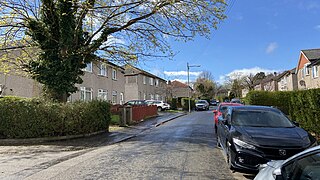
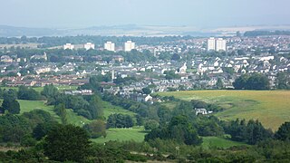
Silverton is a large housing scheme in Dumbarton East, Scotland, located between Dumbarton Rock and Dumbuck Hill and Round Riding Road to the north. It derives its name from the farm upon which it is now located.
It is predominantly a residential area, with both public and private housing stock. Due to its relatively flat geography, the public sector housing was often let to the elderly and infirm of Dumbarton, but now houses a mix of those and commuters to the largest city in Scotland, Glasgow, not far from the town. Dumbarton Academy, the nondenominal public secondary school (though predominantly Protestant) and St. Patrick's Primary School are situated in Silverton, as is the Brock Bowling Club. Dumbarton East railway station is nearby, and so is the East End Park football pitch.
There are three newsagent Shops (one of them has a post office), and a Fish & Chip and Pizzeria take-away shop. There is also a swing park in an area known as The Dam.
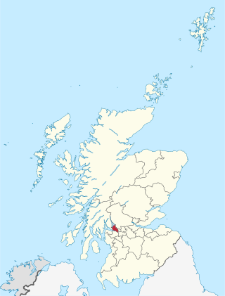
West Dunbartonshire is one of the 32 local government council areas of Scotland. The area lies to the north-west of the City of Glasgow and contains many of Glasgow's commuter towns and villages. West Dunbartonshire also borders Argyll and Bute, East Dunbartonshire, Renfrewshire and Stirling.
Maryhill is an area in the north-west of the City of Glasgow in Scotland. A former independent burgh and the heart of an eponymous local authority ward, its territory is bisected by Maryhill Road, part of the A81 road which runs for a distance of roughly three miles between Glasgow city centre and the suburban town of Bearsden.
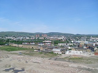
Dumbarton is a town in West Dunbartonshire, Scotland, on the north bank of the River Clyde where the River Leven flows into the Clyde estuary. In 2006, it had an estimated population of 19,990.
Clydebank is a town in West Dunbartonshire, Scotland. Situated on the north bank of the River Clyde, it borders the village of Old Kilpatrick to the west, and the Yoker and Drumchapel areas of the adjacent City of Glasgow immediately to the east. Depending on the definition of the town's boundaries, the suburban areas of Duntocher, Faifley and Hardgate either surround Clydebank to the north, or are its northern outskirts, with the Kilpatrick Hills beyond.
Newton Mearns is a suburban town and the largest settlement in East Renfrewshire, Scotland. It lies 7 miles (11 km) southwest of Glasgow City Centre on the main road to Ayrshire, 410 feet (125 m) above sea level. It has a population of approximately 26,993, stretching from Whitecraigs and Kirkhill in the northeast to Maidenhill in the southeast, to Westacres and Greenlaw in the west and Capelrig/Patterton in the northwest.
Gilesgate is a place in County Durham, England. It is situated east of the centre of Durham. It is also a ward of Durham with a total population taken at the 2011 census was 8,074.
Hillhouse is a council-built housing estate on the western side of the town of Hamilton in South Lanarkshire, Scotland.
Croftfoot is a residential area on the southeastern side of the Scottish city of Glasgow. It is bordered by Castlemilk to the south and King's Park to the west within Glasgow, and by the Rutherglen areas of Spittal to the east and Bankhead to the north. Historically within the civil parish of Cathcart in Renfrewshire, it is within the Linn ward of Glasgow City Council.
Bellsmyre is a large housing estate in the town of Dumbarton in West Dunbartonshire, Scotland. Located on the edge of the Kilpatrick Hills in the northeast of Dumbarton, Bellsmyre is one of five predominantly council housing schemes in Dumbarton, the other four being Westcliff, Silverton, Brucehill and Castlehill.
Broomhill is a district in the West End of the city of Glasgow, Scotland. North of the River Clyde, it is bounded by the districts of Thornwood and Partick to the south, Hyndland to the east, and Jordanhill, Scotstoun and Victoria Park to the west.
Longstone is a suburb of Edinburgh in Scotland. The area is primarily residential in nature, although the area includes several small shops, eateries and supermarkets, as well as one of the main bus depots for the city's buses. The population of Longstone was 4,678 in 2019.
Dumbarton East is an area of the town of Dumbarton, Scotland. It mainly consists of Victorian-era sandstone buildings built by the Denny shipbuilding company to house its workers. Within this area is Dumbarton Castle and the Bet Butler Stadium - home of Dumbarton F.C.
Goldenacre is an area in Edinburgh, Scotland, lying on and to the south of the Ferry Road, and south of Trinity.
Craigievar Estate is a modern housing estate situated in the suburb of East Craigs to the west of Edinburgh, Scotland. The name is comes from Craigievar Castle in Aberdeenshire.
Dalmuir is an area nine miles northwest of Glasgow, Scotland, on the western side of Clydebank, and part of West Dunbartonshire Council Area. The name is a lowland Scots derivation of the Gaelic meaning Big Field. The area was originally two separate villages with Dalmuir Shore joining with Clydebank in 1886 and Dalmuir Village in 1906, during a period of rapid industrialization and expansion. Dalmuir is bounded by the village of Old Kilpatrick to the west, the Mountblow and Parkhall housing schemes to the north, and the Clydebank town centre area to the east. To the south is the River Clyde.
King's Park is a district in the city of Glasgow, Scotland. It is situated south of the River Clyde and borders the Glasgow areas of Croftfoot, Cathcart, Simshill, Mount Florida and Toryglen and the neighbourhood of Bankhead in the adjoining town of Rutherglen.
Woodlands is a large, prosperous central area (ward) of Falkirk, Stirlingshire, Scotland, which is mainly residential. Much of the ward is taken up by leafy streets where property prices are among the highest in Central Scotland and includes Lochgreen, Slamannan, Rosebank, Gartcows and Southern Pleasance areas. Many of the Victorian and Edwardian houses were built by wealthy industrialists who had profited from Falkirk's economic prosperity during the industrial revolution, often without regard to expense.
Moredun is a district in the south-east of Edinburgh, the capital of Scotland. It is east of Liberton, while Craigour is situated just to its north.
Carrick Knowe is a suburb in the west of Edinburgh in Scotland, located approximately 3 miles from the city centre. It is bordered by Tyler's Acre to the north, the Glasgow/Aberdeen railway line to the south, Carrick Knowe Golf Course to the east, and Saughton Road North to the west. The catchment area for the primary school encompasses this entire area. It is often considered part of Corstorphine, however it has its own shopping areas, primary school, parish church and public park.
This page is based on this Wikipedia article Text is available under the CC BY-SA 4.0 license; additional terms may apply. Images, videos and audio are available under their respective licenses.