Forestmill

Last updated

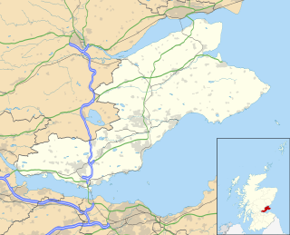
Forestmill (or Forest Mill) is a small hamlet in the county of Clackmannanshire, Scotland. It is situated on the A977 road between Kincardine and Kinross, about 3 miles from the Kincardine end.

Clackmannanshire Council area of Scotland

Clackmannanshire is an historic county and council area in Scotland, bordering the council areas of Stirling, Fife and Perth & Kinross and the historic counties of Perthshire, Stirlingshire and Fife.

Scotland Country in Europe, part of the United Kingdom

Scotland is a country that is part of the United Kingdom. Sharing a border with England to the southeast, Scotland is otherwise surrounded by the Atlantic Ocean to the north and west, the North Sea to the northeast, the Irish Sea to the south, and the North Channel to the southwest. In addition to the mainland, situated on the northern third of the island of Great Britain, Scotland has over 790 islands, including the Northern Isles and the Hebrides.

Kincardine-on-Forth Town in Fife, Scotland

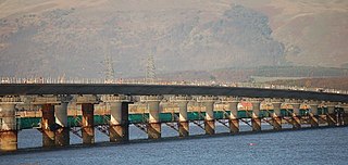
Kincardine or Kincardine-on-Forth is a small town on the north shore of the Firth of Forth, in Fife, Scotland. The town was given the status of a burgh of barony in 1663. It was at one time a reasonably prosperous minor port. The townscape retains many good examples of Scottish vernacular buildings from the 17th, 18th and early 19th centuries, although it was greatly altered during the construction of Kincardine Bridge in 1932–1936.

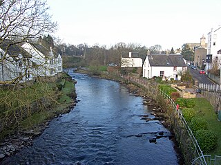
The Black Devon river runs through it towards the town of Clackmannan. [1] A notable feature on the river within Forestmill is a horseshoe weir. This was built in 1711 by George Sorocold to direct water from the river through a sluice into the mill lade that fed the Gartmorn Dam reservoir. [2] [3] The weir was added to the schedule of British listed monuments in 1972.

Black Devon river in the United Kingdom

The Black Devon is a river in Scotland. It rises in the Cleish Hills, specifically the area known as Outh Muir, 1.5 kilometres (0.93 mi) north of Knockhill Racing Circuit, around 9 kilometres (5.6 mi) north-west of Dunfermline, Fife, with the gathering of three small streams in branch formation. The river flows westwards through Balgonar, north of Saline, and then merges with the Saline Burn. The Black Devon flows into Clackmannanshire, through the hamlet of Forestmill and past the town of Clackmannan. The Black Devon enters the River Forth south of Alloa, 1 kilometre (0.62 mi) north of Dunmore Pier.

George Sorocold British engineer

George Sorocold was an engineer in Derby, England, in the eighteenth century.

Mill race channel for water driving a water wheel

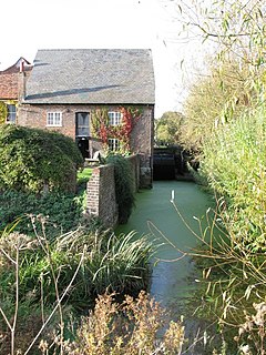
A mill race, millrace or millrun is the current of water that turns a water wheel, or the channel (sluice) conducting water to or from a water wheel. Compared to the broad waters of a mill pond, the narrow current is swift and powerful. The race leading to the water wheel on a wide stream or mill pond is called the head race, and the race leading away from the wheel is called the tail race.

The Scottish poet Michael Bruce taught at the primary school for several months before his death in 1767. [4]

Michael Bruce (poet) Scottish poet and hymnist

Michael Bruce was a Scottish poet and hymnist.

The Clackmannanshire Council website shows the hamlet with a population of 55 in 2009, making it the smallest settlement in the county. However, in 2009, initial planning permission was granted for a significant expansion of the village by the Muir Group. A proposal to build over 1,200 houses, shops, hotel and golf course has been agreed by the council, despite some opposition by local residents. [5]

See also

Related Research Articles

Alloa town in Clackmannanshire, Scotland

Alloa is a town in Clackmannanshire in the Central Lowlands of Scotland. It is on the north bank of the Forth at the spot where some say it ceases to be the River Forth and becomes the Firth of Forth. Geographically, Alloa is south of the Ochil Hills, 5.5 miles (8.9 km) east of Stirling and 7.9 miles (12.7 km) north of Falkirk; by water Alloa is 25 miles (40 km) from Granton.

Stirlingshire Historic county in Scotland

Stirlingshire or the County of Stirling is a historic county and registration county of Scotland. Its county town is Stirling.

Earl of Elgin

Earl of Elgin is a title in the Peerage of Scotland, created in 1633 for Thomas Bruce, 3rd Lord Kinloss. He was later created Baron Bruce, of Whorlton in the County of York, in the Peerage of England on 30 July 1641. The Earl of Elgin is the hereditary Clan Chief of Clan Bruce.

Clackmannan (district) Scottish local government district (1975-1996), part of Central region

From 1975, Clackmannan was the name of a small town and local government district in the Central region of Scotland, corresponding to the traditional county of Clackmannanshire, which was Scotland's smallest. The town of Clackmannan, in which the 'Stone' - a prehistoric monolith of probable cultic significance in the Iron Age - remains, was the chief settlement of its area from the Middle Ages, until supplanted from the second half of the 18th century by the growing manufacturing town of Alloa, on the north shore of the Firth of Forth. The medieval castle of Clackmannan Tower stands above the town and is a landmark visible for many miles around. Dating from the 14th century, though much altered, the Tower is at present not open to the public, having been rendered dangerous by subsidence due to coal-mining.

Allan Water river in United Kingdom

The Allan Water is a river in central Scotland. Rising in the Ochil Hills, it runs through Strathallan to Dunblane and Bridge of Allan before joining the River Forth. It is liable to cause floods in lower Bridge of Allan.

Kincardine Bridge road bridge crossing the Firth of Forth, Scotland

The Kincardine Bridge is a road bridge crossing the Firth of Forth from Falkirk council area to Kincardine, Fife, Scotland.

Dollar, Clackmannanshire small town in Clackmannanshire, Scotland

Dollar is a small town in Clackmannanshire, Scotland. It is one of the Hillfoots Villages, situated between the Ochil Hills range to the north and the River Devon to the south. Dollar is on the A91 road, which runs from Stirling to St Andrews. The town is around 3 miles east of Tillicoultry. The parish of Muckhart extends right up to the eastern edge of Dollar, despite Muckhart's much smaller size. This encompassed Dollar Mine and Pitgober.

Menstrie post town in Clackmannanshire, scottland

Menstrie is a village in the county of Clackmannanshire in Scotland. It is about 5 miles east-north-east of Stirling and is one of a string of towns that, because of their location at the base of the Ochil Hills, are collectively referred to as the Hillfoots Villages or simply The Hillfoots.

Blue Ridge, Alberta Hamlet in Alberta, Canada

Blue Ridge is a hamlet in northwest Alberta, Canada within Woodlands County. It is located on Highway 658, 7 kilometres (4.3 mi) north of Highway 43 and 3 kilometres (1.9 mi) south of the Athabasca River. It is midway between the towns of Whitecourt and Mayerthorpe and approximately 159 kilometres (99 mi) northwest of Edmonton.

The Kincardine Line is a railway in Clackmannanshire and Fife, Scotland. It was originally built to serve settlements along the north shore of the Firth of Forth, between Alloa and Dunfermline.

Clackmannanshire Bridge Road bridge over the River Forth, Scotland

The Clackmannanshire Bridge is a road bridge over the Firth of Forth in Scotland which opened to traffic on 19 November 2008. Prior to 1 October 2008 the bridge was referred to as the upper Forth crossing while the name was chosen.

Sauchie village in Clackmannanshire, Scotland

Sauchie is a village in the Central Lowlands of Scotland. It lies north of the River Forth and south of the Ochil Hills, within the council area of Clackmannanshire. Sauchie has a population of around 6000 and is located 1.0 mile (1.6 km) north-east of Alloa and 2.1 miles (3.4 km) east-southeast of Tullibody.

Sauchie Tower

Sauchie Tower, also known as Devon Tower, is a 15th-century tower house in Clackmannanshire, Scotland. The tower is located by the village of Fishcross, 1 kilometre (0.62 mi) north of Sauchie and 2.5 kilometres (1.6 mi) north of Alloa, close to the River Devon. It is protected as a Scheduled Ancient Monument.

Events from the year 1711 in Scotland.

References

  1. David M. Munro (2006). Scotland: An Encyclopedia of Places & Landscapes. Collins. ISBN   978-0-00-472466-9.
  2. Samuel Lewis (1 January 1989). Topographical Dictionary of Scotland. Genealogical Publishing Com. pp. 39–. ISBN   978-0-8063-1255-2.
  3. Roland Paxton; J. Shipway (1 January 2007). Civil Engineering Heritage Scotland: Lowlands and borders. Thomas Telford for the Institution of Civil Engineers. ISBN   978-0-7277-3487-7.
  4. Scotland; Society for the Benefit of the Sons and Daughters of the Clergy (1845). The New Statistical Account of Scotland: Dunbarton, Stirling, Clackmannan. W. Blackwood and Sons. pp. 2–.
  5. "Forestmill development boost for Clackmannanshire" STV 18 June 2009

Coordinates: 56°7′30″N3°41′12″W / 56.12500°N 3.68667°W / 56.12500; -3.68667

Geographic coordinate system Coordinate system

A geographic coordinate system is a coordinate system that enables every location on Earth to be specified by a set of numbers, letters or symbols. The coordinates are often chosen such that one of the numbers represents a vertical position and two or three of the numbers represent a horizontal position; alternatively, a geographic position may be expressed in a combined three-dimensional Cartesian vector. A common choice of coordinates is latitude, longitude and elevation. To specify a location on a plane requires a map projection.