
A primary school, elementary school, or grade school is a school for primary education of children who are 4 to 10 years of age. Primary schooling follows preschool and precedes secondary schooling.

A school is both the educational institution and building designed to provide learning spaces and learning environments for the teaching of students under the direction of teachers. Most countries have systems of formal education, which is sometimes compulsory. In these systems, students progress through a series of schools that can be built and operated by both government and private organization. The names for these schools vary by country but generally include primary school for young children and secondary school for teenagers who have completed primary education. An institution where higher education is taught is commonly called a university college or university.
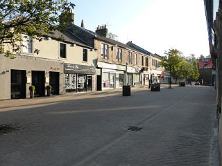
Milngavie is a town in East Dunbartonshire, Scotland and a suburb of Glasgow. It is on the Allander Water, at the northwestern edge of Greater Glasgow, and about ten kilometres from Glasgow city centre. It neighbours Bearsden. Milngavie is a commuter town, with much of its working population travelling to Glasgow to work or study. The town is served by Milngavie railway station on the North Clyde Line of the SPT rail network, which links it to Central Glasgow.

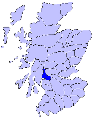
East Dunbartonshire is one of the 32 council areas of Scotland. It borders Glasgow City Council Area to the south, North Lanarkshire to the east, Stirling to the north, and West Dunbartonshire to the west. East Dunbartonshire contains many of the suburbs in the north of Greater Glasgow, including Bearsden, Milngavie, Bishopbriggs, Kirkintilloch, Lenzie, Twechar, Milton of Campsie, Balmore, and Torrance, as well as some other of Glasgow's commuter towns and villages. The council area covers parts of the historic counties of Dunbartonshire, Lanarkshire, and Stirlingshire.

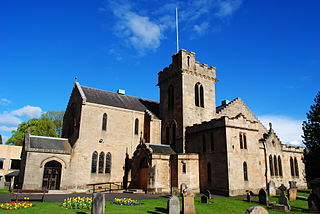
Kirkintilloch is a town and former barony burgh in East Dunbartonshire, Scotland. It lies on the Forth and Clyde Canal and on the south side of Strathkelvin, about 8 miles (13 km) northeast of central Glasgow. Historically part of Dunbartonshire, the town is the administrative home of East Dunbartonshire council area, its population in 2009 was estimated at 19,700 and its population in 2011 was 19,689.

Douglas Academy is a non-denominational, co-educational, comprehensive secondary school in the town of Milngavie, East Dunbartonshire, serving the Milngavie, Craigton and Baldernock areas. In 2007, Douglas Academy was ranked as Scotland's top performing state school, and with every year the school continues to place among the highest in Scotland.

Robroyston is a suburb of Glasgow, Scotland, located around three miles northeast of the city centre.
The Lennox is a region of Scotland centred on The Vale of Leven, including its great loch: Loch Lomond.

Baldernock meaning 'settlement of St Earnaig' is a small parish in East Dunbartonshire, Scotland, ten miles (16 km) to the north of Glasgow's city centre.
New Kilpatrick, is an ecclesiastical Parish and former Civil Parish in Dunbartonshire. It was formed in 1649 from the eastern half of the parish of Kilpatrick, the western half forming Old Kilpatrick. New Kilpatrick is also a disused name for the town of Bearsden.
Campsie is a civil parish in East Dunbartonshire, Scotland. The parish was formerly part of Stirlingshire.

Primary education is typically the first stage of formal education, coming after preschool/kindergarten and before secondary school. Primary education takes place in primary schools, elementary schools, or first schools and middle schools, depending on the location. Hence, in the United Kingdom and some other countries, the term primary is used instead of elementary.

James Couper was a Scottish astronomer. He was Professor of Astronomy at the University of Glasgow from 1803 to 1836.
Bardowie is a hamlet in East Dunbartonshire located within the civil parish of Baldernock. It is two miles from Milngavie and four miles from Strathblane. Along with other settlements in Baldernock, it was part of Stirlingshire until 1975, when Bardowie became part of the Strathclyde region. In 1996 another reorganisation placed Bardowie in East Dunbartonshire. The 1795 Richardson Thomas map of the town of Glasgow & country seven miles around refers to Bardowie as "Barduie".

Torrance railway station was opened in 1879 on the Kelvin Valley Railway and served the area of the village of Torrance in East Dunbartonshire until 1951 for passengers and 1959 for freight.
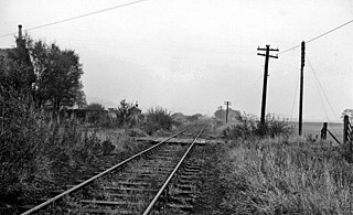
Bardowie railway station was opened in 1905 on the Kelvin Valley Railway, later than most of the other stations which had opened with the line itself in 1879. It served the hamlet of Bardowie and the coal mining area, farms, etc. in East Dunbartonshire until 1931 for passengers and to freight on 31 July 1961.

