Salsburgh

Last updated

Salsburgh
North Lanarkshire UK location map.svg
Red pog.svg
Salsburgh
Location within North Lanarkshire
Population1,330 (mid-2020 est.) [1]
OS grid reference NS825625
Council area
Lieutenancy area
Country Scotland
Sovereign state United Kingdom
Post town SHOTTS
Postcode district ML7
Dialling code 01698 870/1
Police Scotland
Fire Scottish
Ambulance Scottish
UK Parliament
Scottish Parliament
List of places
UK
Scotland
55°50′29″N3°52′41″W / 55.84136°N 3.87795°W / 55.84136; -3.87795

Salsburgh is a semi-rural former coal mining village in greenbelt farmland within the district of North Lanarkshire, Scotland. The closest major towns to the village are Shotts, three miles (five kilometres) southeast, and Airdrie three miles (five kilometres) northwest.

Contents

Salsburgh is perhaps best known for the floodlit Kirk O' Shott's Church, which sits on a hillock and is fairly visible as visitors enter the village from the east on the B7066 Whitburn to Newhouse road. As well as the busy M8 Motorway which runs adjacent to the B7066 and gives the Church the affectionate title 'The M8 Church'. [2]

Founding

There has been a community in the area for over 600 years, although the present village dates back to 1729.[ citation needed ] At that time only a row of four houses existed, named "Muirhall, Girdhimstrait, Merchanthall and Craighead". Craighead was home to a Mr. Young and his wife Sally, [3] and when Young sold some of his land to construct more houses it was decided that it would be named "Sallysburgh". Through time the name was shortened to Salsburgh.

Streets around the village are named after significant natives from its past relating to industry, mining, farming and agriculture.

Coal mining [4]

Duntilland

Duntilland Colliery began production in 1896 with a workforce of just under 200. Their main production was specializing in coal types of/in manufacturing, anthracite and steam. It closed in 1951 and was owned and operated by Coltness Iron Co. Ltd.

Fortissat

Fortissat Colliery began production in 1870 with a workforce of just under 300. Their main production was specializing in coal types of/in-house and steam. It closed in 1949 and was owned and operated by Shotts Iron Co. Ltd.

Ardenrigg

Ardenrigg Colliery began production in 1926 with a workforce of just under 300. Their main production was specializing in coal types of/in anthracite. It closed in 1963 and was owned and operated by Ardenrigg Coal Co. Ltd.

Dewshill

Dewshill Collierie began production in 1896. The population of their workforce is not known. Their main production was specializing in coal types of/in anthracite. It closed in 1943 after being redeveloped in 1923 and was owned and operated by Coltness Iron Co. Ltd. The pumping shaft eventually sunk in 1957.

Hirstrigg

Hirstrigg Collierie began production sometime around after 1880 with a work force of between 200 and 300. It is not known what coal type they specialized in. It was originally owned and operated by Hirst Coal Co. Ltd (Glasgow) then latterly became under the ownership of Garscube Coal Co. Ltd (Edinburgh). It closed sometime around the 1940s. [4]

Facilities

Kirk O' Shott's (Shottskirk) Public/Primary School

Kirk O' Shott's is the name of the local school which opened initially in 1700 in a rented building in the southern edge of the old Shottskirk churchyard; however, it was decided that a new school would be built opposite the church on what is now Newmill Canthill Road. It officially opened in 1799.

Due to an increase in school roll the original school was deemed no longer viable. A new school was built to the east end of the village and was opened in August 1912 as Shottskirk Public School, [5] which later reverted to its original roots as Kirk O' Shott's in 1958 as a junior / secondary school.

The school celebrated its centenary on 12 August 2012. Kirk O' Shott's remains a public school open to all denominations.

Kirk O' Shott's (Shottskirk) Parish Church

Kirk O' Shott's Parish Church is the name of the local church which serves the parish of Salsburgh, Shotts and surrounding area. [6] The church was formerly a Catholic place of worship under the name St. Catherines, taken from Catherine of Sienna. [7] About 550 years ago Bothwell and Shotts formed one parish which stretched from the Clyde to Linlithgowshire, and from the North to the South Calder. In this large area there were four places of worship, one of which was situated in the middle Bothwellmuir.

St. Catherine's Chapel was built in 1450. It was dedicated to "the blessed Virgin and Catherine of Sienna".

After the Reformation of 1560, Kirk o’Shotts, otherwise known as Shottskirk or the affectionately titled "M8 Church", became a Protestant place of worship. The old church of St Catherine's must have suffered many changes and required frequent changes since its foundation, but of these there is no account before 1640. In that year the Presbytery met at Shotts and ordered that the church be repaired and partly rebuilt, but it was more than eight years before the work was completed. The site of the old church is marked by the headstone erected to Samuel Meuros, who was session clerk and school master from 1794 to 1837. He was also Precentor, and it was his wish to be buried where his old desk had stood; thus he lies still at his post. On the back of the stone is the following inscription:

"Here stood the Precentor’s desk in the Kirk of Bertram Shotts which was rebuilt and extended in 1642".

This stone and the burial ground of the Inglises of Murdoston, which was inside the old church, give a clear idea of the site.

St. Catherine's Well / "Kate's Well"

St. Catherine's Well or "Kate's Well" is a natural holy spring well on holy ground at the foot of Kirk O'Shott's Parish Church, [8] otherwise known as Shottskirk, in the village of Salsburgh, North Lanarkshire. The well dates back to the 14th century and derives from the church's former past when it was a Catholic place of worship as St. Catherines Chapel which has origins from Catherine of Sienna.

Kate's Well was also the scene of the local legendary giant Bertram de Shotts' demise where his head was decapitated as he drank from the well.

Skate park

In November 2019 it was announced that funding would be released for a new skate park, to be located top end of the King George Fifth park off Bogfoot Road and Reid Street. Work commenced on the skate park in October 2021 and completed in early 2022.

Miner statue

In November 2019 it was also announced along with the new skate park, would be a new miner statue to commemorate the villages rich mining history. This has since been abandoned.

The Transmitters

Salsburgh is the locale of the twin BlackHill Transmitters due to its high position towering above the M8 motorway opposite the church. They can be seen as far as Bathgate, West Lothian to the east and Glasgow to the west. The transmitters are quite a prominent feature after dark for miles around, due to the coloured red lights which prevent aircraft from striking the towers.

The Kirk o'Shotts transmitting station is also nearby, which formerly carried a TV service and today carries DAB radio.

Pre-fabricated buildings

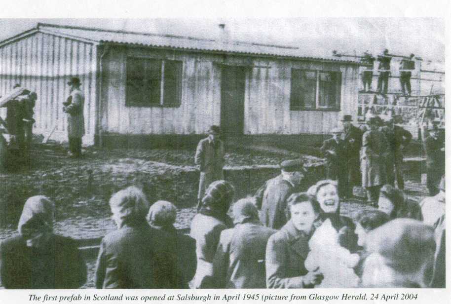
Salsburgh was one of the first places in Scotland to have a "pre-fab", a prefabricated home with corrugated steel walls built. The first pre-fab in the UK was built in the village in 1945. [9]

Schools and nurseries

Places of worship

Geography

Climate

Salsburgh has an oceanic climate (Köppen: Cfb).

Climate data for Salsburgh (277 m or 909 ft asl, averages 1981–2010)
MonthJanFebMarAprMayJunJulAugSepOctNovDecYear
Mean daily maximum °C (°F)4.9
(40.8)
5.2
(41.4)
7.1
(44.8)
10.0
(50.0)
13.1
(55.6)
15.7
(60.3)
17.5
(63.5)
17.1
(62.8)
14.5
(58.1)
10.9
(51.6)
7.4
(45.3)
5.1
(41.2)
10.7
(51.3)
Mean daily minimum °C (°F)0.2
(32.4)
0.1
(32.2)
1.1
(34.0)
2.7
(36.9)
5.4
(41.7)
8.0
(46.4)
9.9
(49.8)
9.7
(49.5)
8.0
(46.4)
5.1
(41.2)
2.4
(36.3)
0.5
(32.9)
4.4
(40.0)
Average rainfall mm (inches)105.9
(4.17)
77.2
(3.04)
93.6
(3.69)
62.0
(2.44)
68.6
(2.70)
75.9
(2.99)
83.4
(3.28)
104.3
(4.11)
99.5
(3.92)
122.9
(4.84)
98.5
(3.88)
100.9
(3.97)
1,092.7
(43.03)
Average rainy days (≥ 1 mm)17.112.815.712.912.512.913.514.713.916.916.115.5174.5
Source: Met Office [10]

STV have reported several times from the village, most notably in relation to extreme weather conditions such as snow. Salsburgh also has a MET office weather Observation Station: (Lat: 55.8667 | Long: -3.8667).

Homes

Throughout the years there have been a variety of mixed styles of properties in the village, beginning with prefabs (prefabricated structures with tin roofs) which were then replaced with more substantial council authority brick-built homes.

The village today consists of detached, semi-detached, terraced, bungalows, cottages, miners' row cottages (most of which are council authority and/or privately owned former local authority properties) and also fully renovated former derelict properties and new builds such as Salsburgh Meadows and the new builds situated in sections of Main Street.

The mix of old (miners' rows) and new (Salsburgh Meadows) makes the village quaint and gives it a certain charm retaining the old buildings from years gone by.

Salsburgh is one of the only places in North Lanarkshire that does not have a gas main, as it was not cost effective when the pipes were being laid. Services are provided independently by oil/LPG and coal suppliers.

Most street names within the village have some significance to the village's history and/or former residents.

Landmarks

Other landmarks include the footbridge which crosses the B7066 main road, which was struck by a careless crane driver in 2009. [11] It was rebuilt and reopened in 2014.

Population

The 2001 United Kingdom census recorded a population of 1310. It was estimated as of 2018 that the village currently is populated by 1370 residents. [12]

Nearby towns and villages

Government and local groups

As of May 2022, the candidates elected to serve in Ward 13 Fortissat are: [13]

Local provost:

Deputy Provost:

The local MP is Anum Qaisar-Javed (SNP).

The local Constituency MSP is Neil Gray (SNP).

The Central Scotland regional MSPs for North Lanarkshire are: [14]

Local groups

There are several local groups in the village which have been set up to provide a service to the community.

Community Council provide information pertaining to planning, local interest surrounding the village and further awareness of events in the village.

Notable natives

Related Research Articles

<span class="mw-page-title-main">Lanarkshire</span> Historic county in Scotland

Lanarkshire, also called the County of Lanark, is a historic county, lieutenancy area and registration county in the Central Lowlands of Scotland. The county is no longer used for local government purposes, but gives its name to the two modern council areas of North Lanarkshire and South Lanarkshire.

<span class="mw-page-title-main">Wishaw</span> Town North Lanarkshire, Scotland

Wishaw is a large town in North Lanarkshire, Scotland, on the edge of the Clyde Valley, 15 miles (24 km) south-east of Glasgow city centre. The Burgh of Wishaw was formed in 1855 within Lanarkshire. It formed a joint large burgh with its neighbour Motherwell from 1920 until its dissolution when Scottish local authorities were restructured in 1975, and was then in Motherwell district within the Strathclyde region until 1996. The town is part of the Motherwell and Wishaw constituency. It has the postal code of ML2 and the dialling code 01698.

<span class="mw-page-title-main">Cleland, North Lanarkshire</span> Village in Scotland

Cleland is a village near Motherwell and Wishaw in North Lanarkshire, Scotland,. As of 2018, it has a population of about 3,000. The village has a strong coal mining heritage, and is a typical example of a working class village in North Lanarkshire and the Glasgow area. Due to its location, despite being at the heart of North Lanarkshire, the village is isolated, geographically and culturally, from surrounding towns such as Motherwell, Shotts and Wishaw.

<span class="mw-page-title-main">Uddingston</span> Human settlement in Scotland

Uddingston is a small town in South Lanarkshire, Scotland. It is on the north side of the River Clyde, south-east of Glasgow city centre, and acts as a dormitory suburb for the city.

<span class="mw-page-title-main">Airdrie and Shotts (UK Parliament constituency)</span> Parliamentary constituency in the United Kingdom, 1997 onwards

Airdrie and Shotts is a constituency of the UK House of Commons, located in central Scotland within the North Lanarkshire council area. It elects one Member of Parliament (MP) at least once every five years using the first-past-the-post system of voting.

<span class="mw-page-title-main">Fauldhouse</span> Human settlement in Scotland

Fauldhouse is a village in West Lothian, Scotland. It is about halfway between Glasgow and Edinburgh. The nearest towns to Fauldhouse are Whitburn and Livingston. Other neighbouring villages include Longridge, Shotts and Stoneyburn. At approximately 750 feet above sea level, Fauldhouse is one of the highest villages in West Lothian.

<span class="mw-page-title-main">Addiewell</span> Human settlement in Scotland

Addiewell is a former mining village in the Scottish council area of West Lothian. Historically it lies within the County of Midlothian. A new prison, HMP Addiewell, opened in 2008.

<span class="mw-page-title-main">Harthill, Scotland</span> Human settlement in Scotland

Harthill is a rural village split between North Lanarkshire and West Lothian in Scotland, with most of the village in North Lanarkshire. It is located about halfway between Glasgow, 21 miles to the west, and Edinburgh, 25 miles (40 km) to the east. It lies on the River Almond about 2+12 miles (4 km) west of the small town of Whitburn. The closest major towns are Bathgate, 6 miles (9.7 km) away, and Livingston, 10 miles (16 km) away. Major towns within North Lanarkshire, such as Wishaw, Airdrie, Motherwell, Coatbridge and Bellshill are all around 10 to 15 miles to the west. The M8 motorway bypasses the village and Harthill has a service station named after it.

<span class="mw-page-title-main">Shotts</span> Human settlement in Scotland

Shotts is a small town in North Lanarkshire, Scotland. It is located almost halfway between Glasgow and Edinburgh. The town has a population of about 8,840. A local story has Shotts being named after the legendary giant highwayman Bertram de Shotts, though toponymists give the Anglo-Saxon scēots as the real source of the name. Shotts is the home of the world famous Shotts and Dykehead Caledonia Pipe Band, 16 time winners of World Pipe Band Championships.

<span class="mw-page-title-main">Plains, North Lanarkshire</span> Human settlement in Scotland

Plains is a village outside the town of Airdrie, in North Lanarkshire, Scotland, about 14 miles (23 km) east of Glasgow city centre and 32 miles (51 km) west of Edinburgh. The nearest major towns are Airdrie and Coatbridge. The village is west of Caldercruix and the North Calder Water. The population is about 2,740.

<span class="mw-page-title-main">Newhouse, North Lanarkshire</span> Human settlement in Scotland

Newhouse is a hamlet and major road interchange located in North Lanarkshire, Scotland, sited immediately east of the Eurocentral industrial park, two miles west of the village of Salsburgh, 1.8 miles (2.9 km) east of Holytown and about 4 miles (6.4 km) north east of Motherwell.

The Kirk o' Shotts transmitting station is a broadcasting and telecommunications site at The Hirst which lies just outside the village of Salsburgh which is near the town of Shotts in North Lanarkshire central Scotland.

<span class="mw-page-title-main">Shottskirk</span>

Shottskirk, more commonly known as Kirk O'Shotts Parish Church, or affectionately "The M8 Church", is a local parish church located in Salsburgh, North Lanarkshire, Scotland, and serves the village of Salsburgh, the town of Shotts and the hamlets in between. The last dedicated minister for this church was Rev. Sheila Spense who retired in 2000.

Bertram de Shotts is known locally as a legendary giant that roamed the then village of Shotts, Scotland in the 15th century. Shotts was then a dreary moorland place on the Great Road of the Shire. The road was an important route for tradesmen carrying their wares around Scotland. Bertram de Shotts habitually savaged packmen and peddlers for treasure carried along the Great Road. Such was the menace of Bertram de Shotts, King James IV of Scotland ordered his death. Bertram de Shotts was probably in fact seven or eight feet high, yet nonetheless, his presence merited Giant status.

<span class="mw-page-title-main">Deans, West Lothian</span> Human settlement in Scotland

Deans is a small community within the town of Livingston in West Lothian, Scotland. Deans is situated in the northern part of Livingston, The western area of Deans was formerly known as Livingston Station, as it is the location of former oil works and a railway station. Many people who have lived in this area for a long time often refer to it as such. In 2010 the population of Deans was 3,641.

<span class="mw-page-title-main">Allanton, North Lanarkshire</span> Human settlement in Scotland

Allanton is a village on the A71, in North Lanarkshire, Scotland.

<span class="mw-page-title-main">Newmains</span> Human settlement in Scotland

Newmains is a village and former mining community on the eastern edge of Wishaw, North Lanarkshire, Scotland, 18 miles (29 km) south-east of Glasgow. Although it is considered by the local authority to have a town centre in its own right.

<span class="mw-page-title-main">New Stevenston</span> Village in North Lanarkshire, Scotland

New Stevenston is a village situated between Motherwell and Bellshill in North Lanarkshire, Scotland. Most local amenities are shared with the adjacent villages of Carfin, Holytown and Newarthill which have a combined population of around 20,000 across the four localities.

<span class="mw-page-title-main">Kate's Well</span>

St. Catherine's Well or Kate's Well is a historical natural spring well of significant interest and sits on holy ground, at the foot of Kirk O' Shott's Parish Church, otherwise known as (Shottskirk) in the village of Salsburgh, North Lanarkshire. The well dates back to the 15th century, and derives from the church's former past when it was once a Catholic place of worship as St. Catherines Chapel, which has origins from Catherine of Sienna.

<span class="mw-page-title-main">Drumclog</span> Human settlement in Scotland

Drumclog is a small village in South Lanarkshire, Parish of Avendale and Drumclog, Scotland. The habitation is situated on the A71, between Caldermill and Priestland in East Ayrshire at a height of 196.7m and about 5 miles west of Strathaven.

References

  1. "Mid-2020 Population Estimates for Settlements and Localities in Scotland". National Records of Scotland. 31 March 2022. Retrieved 31 March 2022.
  2. "Church who haven't had minister for six years make SOS sign for M8 motorway". 22 July 2016.
  3. "Salsburgh from the Gazetteer for Scotland".
  4. 1 2 "Mining". Salsburgh Heritage Group.
  5. "Shottskirk Public School". Archived from the original on 22 April 2016. Retrieved 21 February 2022.
  6. "Shottskirk, Shotts".
  7. "Local Churches".
  8. "Kirk of Shotts, St Catherine's Chapel, Kirk Well and Martyr's Grave | Canmore".
  9. "1945 photograph of prefabricated building in Salsburgh". Glasgow Herald. 24 April 2004 via Salsburgh Heritage Group.
  10. "Salsburgh (North Lanarkshire) UK climate averages". Met Office. Archived from the original on 24 March 2020. Retrieved 24 March 2020.
  11. "Miracle escape as lorry destroys bridge". Daily Record. 30 June 2009.
  12. "Salsburgh (North Lanarkshire, Scotland, United Kingdom) - Population Statistics, Charts, Map, Location, Weather and Web Information". www.citypopulation.de.
  13. "Ward 13 Fortissat | North Lanarkshire Council".
  14. "Central Scotland regional members of Scottish parliament". North Lanarkshire Council.
  15. "Shotts Feature Page on Undiscovered Scotland". www.undiscoveredscotland.co.uk.
  16. "Jamie Dolan". 2 September 2008.
  17. "Athlete Profile".
  18. "Derek Whiteford". 21 January 2002.
  19. Tonner, Judith (18 May 2020). "Salsburgh writer launches new chapter with publication of children's books". Daily Record.