
North Lanarkshire is one of the 32 council areas of Scotland. It borders the north-east of the Glasgow City council area and contains many of Glasgow's suburbs, commuter towns, and villages. It also borders East Dunbartonshire, Falkirk, Stirling, South Lanarkshire, and West Lothian. The council area covers parts of the historic counties of Dunbartonshire, Lanarkshire, and Stirlingshire. The council is based in Motherwell.
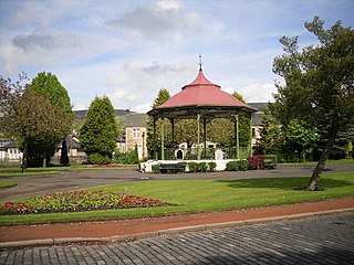
Kilsyth is a town and civil parish in North Lanarkshire, roughly halfway between Glasgow and Stirling in Scotland. The estimated population is 10,380. The town is famous for the Battle of Kilsyth and the religious revivals of the 18th, 19th, and 20th centuries. The town now has links with Cumbernauld at one time being part of Cumbernauld and Kilsyth District Council. The towns also have the same members of parliament at Holyrood and Westminster.

Polmont is a village in the Falkirk council area of Central Scotland. It lies towards the east of the town of Falkirk, north of the Union Canal, which runs adjacent to the village.

Bishopton (/bɪʃəptən/) is a village in Renfrewshire, Scotland. It is located around 2 miles (3 km) west of Erskine.

Cumbernauld Village is an area of Cumbernauld. Whilst Cumbernauld was designated a new town in 1955, the Village itself has a pre-mediaeval history, with a Roman settlement being built in the area due to its proximity to the Antonine Wall. After the Roman period the settlement remained and grew to such an extent that the Comyn family built their chapel there. It is recorded that, in 1500, the Black Death led to a special plea from the surviving people of Cumbernauld to the church authorities in Glasgow to allow them to establish their own cemetery rather than taking all their dead to St. Ninian's in Kirkintilloch. This source is also quoted in "Excavations at 3-11 Main Street, Cumbernauld". The villagers were granted permission to do so, and used the ground at the existing Comyns' chapel which dates from the end of the 12th century. Farming in long strips or Lang Riggs was carried out in the village.

Condorrat is a former village in North Lanarkshire, Scotland. Like Luggiebank, Castlecary and Dullatur, it predates the new town of Cumbernauld, but unlike those Condorrat was officially included in the designated new town area. Since then it has officially been part of Cumbernauld although it retains some of its own distinctive character. Dalshannon Farm and cottages were located in the area west of the original town and farm, and north of the Luggie. So also was a corn mill called Wood Mill. Road signs show they are is now in the western part of Condorrat towards Mollinsburn.

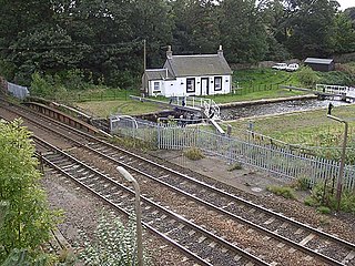
Twechar is a small former mining village historically in Dunbartonshire and administered by the council area of East Dunbartonshire, Scotland close to the boundary with North Lanarkshire. It lies between the larger towns of Cumbernauld, Kilsyth and Kirkintilloch. The Forth and Clyde Canal runs close to the village to the north, and closely follows the line of the Antonine Wall. There are visible remains of the wall on Bar Hill and the Roman Fort is a local tourist attraction.

Banton is a small village situated near Kilsyth in North Lanarkshire, Scotland.

Castlecary is a small historic village in North Lanarkshire, Scotland, directly adjacent to the border with Falkirk. It has long been associated with infrastructure, being adjacent to a bridged river, a Roman fort and roads, a nationwide canal, a Victorian railway viaduct, and a modern motorway. Castlecary is close to the town of Cumbernauld but like Dullatur and Luggiebank is not officially part of the town. Around 1725, the barony of Castlecary, with a population of just seventeen families, was disjoined from the parish of Falkirk, and annexed to Cumbernauld quoad sacra. Castlecary is also near Allandale which, though in the Falkirk council area, was built for Castlecary fireclay workers.

Luggiebank is a small village to the south of Cumbernauld. Like Condorrat, Castlecary and Dullatur, it predates the new town of Cumbernauld, and of those, only Condorrat was officially included in the designated area. It is situated on what used to be the Stirling Road from Lanark, but as a result of a bypass (B8039) the old road is now a cul-de-sac. Unlike the rest of Cumbernauld, which was in Dunbartonshire, Luggiebank was historically in Lanarkshire, but was adopted into Dunbartonshire in 1967, prior to Cumbernauld becoming a police burgh the following year. Following further boundary changes in 1995, Luggiebank became part of North Lanarkshire.
Camelon is a large settlement within the Falkirk council area, Scotland. The village is in the Forth Valley, 1.3 miles (2.1 km) west of Falkirk, 1.3 miles (2.1 km) south of Larbert and 2.6 miles (4.2 km) east of Bonnybridge. The main road through Camelon is the A803 road which links the village to Falkirk. At the time of the 2001 census, Camelon had a population of 4,508.
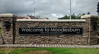
Moodiesburn is a village in Scotland, located 8 miles northeast of Glasgow, in the North Lanarkshire council area. It is situated on the north side of the A80 road and between the M73 and M80 motorways which converge nearby. Moodiesburn does not directly adjoin any other settlements, though the villages of Chryston and Muirhead are located a short distance to the west, with Stepps beyond, and outer parts of Cumbernauld lie to the east; however, the town centres are about 5 miles apart.

Westerwood is an area in the north-east of Cumbernauld in North Lanarkshire, Scotland. Historically it was the site of a Roman Fort of which a video reconstruction has been produced. In the past two decades, new housing developments have been built around the Westerwood Hotel and Golf Course. The golf course, which was designed by Seve Ballesteros and Dave Thomas, is located on the north side of the town, close to Cumbernauld Airport. Westerwood Community Council was set up for local residents and a committee has been appointed. Neighbouring villages which are outside of Cumbernauld include Dullatur to the north-west and Castlecary to the east.

Craigmarloch is a private residential area of the town of Cumbernauld in North Lanarkshire, Scotland. It was the last such area that the Cumbernauld Development Corporation (CDC) laid out and began to construct. The area is designed to be like a village, with features such as: a village green, a main street, focal points, gateways, water features and recreational and community facilities. The responsibility for the development of the area passed from the CDC to North Lanarkshire Council in 1996.
Westfield is an area of the town of Cumbernauld in Scotland. Westfield is a popular residential area originally built by Cumbernauld Development Corporation in the late 1970s and early 1980s. It comprises a residential area and a large industrial estate. Historically there was a farm at Westfield as shown on Roy's map of the Lowlands and the 1st 25 inch Ordnance Survey Map of Scotland. It is located near Condorrat and Broadwood Stadium, home of Clyde FC. Historically, there were two local primary schools, St Francis of Assisi Primary School and Westfield Primary School. St. Francis of Assisi Primary School closed in 2009. The site has been re-developed by North Lanarkshire Council with new, high quality social housing available to rent. The new street is named Netherinch Way. Westfield also has other modern, private developments for example a new Bellway Housing development sits near Broadwood stadium along with a neighboring housing development. Westfield has a selection of frequent bus services to Airdrie, Cumbernauld Town Centre, Glasgow, Kilsyth and Kirkintilloch with buses operated by David Allan Coaches, First Group & McGills. In 2017 plans for a new retail park near Broadwood Studium were approved.

The Antonine Wall was a turf fortification on stone foundations, built by the Romans across what is now the Central Belt of Scotland, between the Firth of Clyde and the Firth of Forth. Built some twenty years after Hadrian's Wall to the south, and intended to supersede it, while it was garrisoned it was the northernmost frontier barrier of the Roman Empire. It spanned approximately 63 kilometres and was about 3 metres high and 5 metres wide. Lidar scans have been carried out to establish the length of the wall and the Roman distance units used. Security was bolstered by a deep ditch on the northern side. It is thought that there was a wooden palisade on top of the turf. The barrier was the second of two "great walls" created by the Romans in Great Britain in the second century AD. Its ruins are less evident than those of the better-known and longer Hadrian's Wall to the south, primarily because the turf and wood wall has largely weathered away, unlike its stone-built southern predecessor.

Mollinsburn is a settlement in the North Lanarkshire area of Scotland. It is situated on the A80 road between Condorrat to the east and Moodiesburn to the west. The population is around 100. It used to be known as Mollinburn and the stream known as Mollins Burn joins the Luggie Water east of the village.
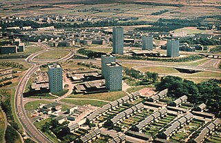
Cumbernauld is a large town in the historic county of Dunbartonshire and council area of North Lanarkshire, Scotland. It is the tenth most-populous locality in Scotland and the most populated town in North Lanarkshire, positioned in the centre of Scotland's Central Belt. Geographically, Cumbernauld sits between east and west, being on the Scottish watershed between the Forth and the Clyde; however, it is culturally more weighted towards Glasgow and the New Town's planners aimed to fill 80% of its houses from Scotland's largest city to reduce housing pressure there.

The Red Burn is one of two main streams which flow out of Cumbernauld. The Scottish New Town’s name derives from the Gaelic for "the meeting of the waters" and there is broad agreement that one of these waters is the Red Burn.

Carrickstone is an area of Cumbernauld, Scotland. It is on the north of the M80 and west of Cumbernauld Town Centre. The area it now occupies used to be covered by Carrickstone farm with the 25 inch Ordnance Survey map showing it between an ancient "standing stone" and The Village.


